Departments of Honduras
Honduras is divided into 18 departments (Spanish: departamentos). Each department is headed by a governor, who is appointed by the President of Honduras. The governor represents the executive branch in the region in addition to acting as intermediary between municipalities and various national authorities; resolves issues arising between municipalities; oversees the penitentiaries and prisons in his department; and regularly works with the various Secretaries of State that form the President's Cabinet. To be eligible for appointment as governor, the individual must a) live for five consecutive years in the department; b) be Honduran; c) be older than 18 years of age and; d) know how to read and write.[1][2][3]
 |
|---|
| This article is part of a series on the politics and government of Honduras |
|
|
|
Legislative
|
|
Judiciary |
|
|
Evolution of Honduras's territorial organization
1825: The constitutional congress convened in that year orders that the state be divided into seven departments: Comayagua, Santa Bárbara, Tegucigalpa, Choluteca, Yoro, Olancho, and Gracias (later renamed Lempira).
1834: An extraordinary constitutional assembly reduces the number of departments to four: this attempt fails to prosper, and the 1825 division remains in force.
1869: Congress orders the creation of the departments of La Paz (broken away from Comayagua), El Paraíso (from Tegucigalpa and Olancho), Copán (from Gracias), and La Mosquitia (from Yoro).
1872: A department called Victoria is ordered to be split from Choluteca, but this never comes into effect. Islas de la Bahía department is founded (the islands were ceded to Honduras by the United Kingdom in 1860).
1881: La Mosquitia joined with portions of Yoro to form Colón department.
1883: Intibucá department is formed from sections of La Paz and Gracias.
1893: Valle department (split from Choluteca) and Cortés department (split from Santa Bárbara) are created.
1902: Parts of Yoro and Colón are taken to form the new department of Atlántida.
1906: Ocotepeque department is created by dividing the territory of Copán.
1957: Colón is divided in two to create Gracias a Dios department.
Departments of Honduras
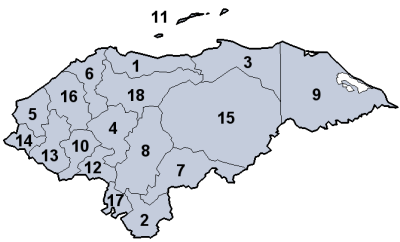
| Department | Department capital | Population (2001 census) | Population (2013 census)[4] | Population change (%) | Area (km2)[5] | Municipalities | |
|---|---|---|---|---|---|---|---|
| 1. | Atlántida | La Ceiba | 344,099 | 436,252 | 4,372 | 8 | |
| 2. | Choluteca | Choluteca | 390,805 | 437,618 | 4,360 | 16 | |
| 3. | Colón | Trujillo | 246,708 | 309,926 | 8,249 | 10 | |
| 4. | Comayagua | Comayagua | 352,881 | 493,466 | 5,124 | 21 | |
| 5. | Copán | Santa Rosa de Copán | 288,766 | 371,057 | 3,242 | 23 | |
| 6. | Cortés | San Pedro Sula | 1,202,510 | 1,562,394 | 3,923 | 12 | |
| 7. | El Paraíso | Yuscarán | 350,054 | 455,507 | 7,489 | 18 | |
| 8. | Francisco Morazán | Tegucigalpa | 1,180,676 | 1,508,906 | 8,619 | 28 | |
| 9. | Gracias a Dios | Puerto Lempira | 67,384 | 90,765 | 16,997 | 6 | |
| 10. | Intibucá | La Esperanza | 179,862 | 232,553 | 3,123 | 17 | |
| 11. | Islas de la Bahía | Roatán | 38,073 | 62,557 | 236 | 4 | |
| 12. | La Paz | La Paz | 156,560 | 198,926 | 2,331 | 19 | |
| 13. | Lempira | Gracias | 250,067 | 321,179 | 4,234 | 28 | |
| 14. | Ocotepeque | Nueva Ocotepeque | 108,029 | 146,030 | 1,630 | 17 | |
| 15. | Olancho | Juticalpa | 419,561 | 520,761 | 24,057 | 23 | |
| 16. | Santa Bárbara | Santa Bárbara | 342,054 | 421,337 | 5,024 | 28 | |
| 17. | Valle | Nacaome | 151,841 | 174,511 | 1,665 | 9 | |
| 18. | Yoro | Yoro | 465,414 | 570,595 | 7,781 | 11 | |
| Total | – | – | 6,535,344 | 8,303,771 | 112,457 |
Population data source:[6]
See also
References
- "Honduras: Political Organization / Organizacion Política". Pdba.georgetown.edu. Retrieved 16 October 2017.
- "DECRETO NUMERO 134-90 : EL CONGRESO NACIONAL" (PDF). Poderjudicial.gob.hn. Retrieved 16 October 2017.
- "Honduras: Political Organization / Organizacion Política". Pdba.georgetown.edu. Retrieved 16 October 2017.
- Honduran National Institute of Statistics Archived 2010-10-17 at the Wayback Machine
- Honduras at GeoHive Archived 2016-08-02 at the Wayback Machine.
- "GeoHive - Honduras population statistics". Web.archive.org. 2 August 2016. Retrieved 16 October 2017.
External links
- Interactive Map of Honduras
- Statoids: Departments of Honduras
- "Geo Postal Codes database (Intibucá)". Mapanet. Madrid, España: Divex Turismo, S.L. Retrieved 11 January 2018.
- "Cuadro de Códigos de Departamentos y Municipios de Honduras" [Table of Honduran Department and Municipality Codes] (PDF). Registro Nacional de las Personas Honduras (RPN) (in Spanish). Tegucigalpa, Honduras. Retrieved 11 January 2018.
- Honduras distance Calculator
Administrative divisions of the Americas | ||
|---|---|---|
| ||
| Sovereign states |
| .svg.png) |
| ||