Benson, New York
Benson is a town in Hamilton County, New York, United States. The population was 192 at the 2010 census.[3] The town is on the south border of Hamilton County and is northwest of Schenectady. The current Town Supervisor is John M. Stortecky .[4]
Benson, New York | |
|---|---|
Town | |
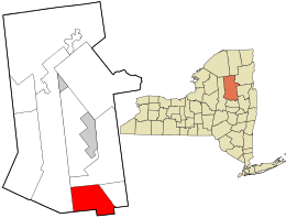 Location in Hamilton County and the state of New York. | |
| Coordinates: 43°15′7″N 74°16′41″W | |
| Country | United States |
| State | New York |
| County | Hamilton |
| Government | |
| • Type | Town Council |
| • Town Supervisor | John M. Stortecky |
| • Town Council | Members' List
|
| Area | |
| • Total | 83.20 sq mi (215.48 km2) |
| • Land | 82.62 sq mi (213.98 km2) |
| • Water | 0.58 sq mi (1.50 km2) |
| Elevation | 2,313 ft (705 m) |
| Population (2010) | |
| • Total | 192 |
| • Estimate (2016)[2] | 181 |
| • Density | 2.32/sq mi (0.90/km2) |
| Time zone | UTC-5 (Eastern (EST)) |
| • Summer (DST) | UTC-4 (EDT) |
| FIPS code | 36-041-05958 |
| GNIS feature ID | 0978723 |
History
Benson was formed in 1860 from the towns of Hope and Mayfield (now in Fulton County). Benson once possessed an iron mine.
Geography
According to the United States Census Bureau, the town of Benson has a total area of 83.2 square miles (215.5 km2), of which 82.6 square miles (214.0 km2) are land and 0.58 square miles (1.5 km2), or 0.70%, are water.[3]
The Sacandaga River runs along part of the southeastern border of the town. The south town line is the border of Fulton County.
New York State Route 30 passes through the southeast corner of Benson.
Demographics
| Historical population | |||
|---|---|---|---|
| Census | Pop. | %± | |
| 1860 | 380 | — | |
| 1870 | 320 | −15.8% | |
| 1880 | 402 | 25.6% | |
| 1890 | 322 | −19.9% | |
| 1900 | 299 | −7.1% | |
| 1910 | 143 | −52.2% | |
| 1920 | 119 | −16.8% | |
| 1930 | 69 | −42.0% | |
| 1940 | 89 | 29.0% | |
| 1950 | 85 | −4.5% | |
| 1960 | 87 | 2.4% | |
| 1970 | 89 | 2.3% | |
| 1980 | 156 | 75.3% | |
| 1990 | 168 | 7.7% | |
| 2000 | 201 | 19.6% | |
| 2010 | 192 | −4.5% | |
| Est. 2016 | 181 | [2] | −5.7% |
| U.S. Decennial Census[5] | |||
As of the census[6] of 2000, there were 201 people, 80 households, and 58 families residing in the town. The population density was 2.4 people per square mile (0.9/km2). There were 160 housing units at an average density of 1.9 per square mile (0.7/km2). The racial makeup of the town was 99.00% White, and 1.00% from two or more races. Hispanic or Latino of any race were 1.49% of the population.
There were 80 households, out of which 28.8% had children under the age of 18 living with them, 56.3% were married couples living together, 7.5% had a female householder with no husband present, and 27.5% were non-families. 20.0% of all households were made up of individuals, and 8.8% had someone living alone who was 65 years of age or older. The average household size was 2.51 and the average family size was 2.81.
In the town, the population was spread out, with 18.4% under the age of 18, 13.9% from 18 to 24, 20.9% from 25 to 44, 30.3% from 45 to 64, and 16.4% who were 65 years of age or older. The median age was 44 years. For every 100 females, there were 103.0 males. For every 100 females age 18 and over, there were 105.0 males.
The median income for a household in the town was $48,250, and the median income for a family was $50,000. Males had a median income of $39,375 versus $23,750 for females. The per capita income for the town was $20,992. None of the families and 2.4% of the population were living below the poverty line, including no under eighteens and 6.8% of those over 64.
Communities and locations in Benson
- Benson – The hamlet of Benson, located on Benson Road at the junction of North Road near the south town line.
- Big Popple – An elevation located north-northeast of Upper Benson.
- Blue Ridge Mountain – An elevation located northwest of Upper Benson.
- Cathead Mountain – An elevation located north of Benson.
- Devorse Creek – A tributary of the Sacandaga River, flowing northward out of Benson.
- Four Staves – An elevation located north-northwest of Upper Benson.
- Jacksons Seat – An elevation located northeast of Upper Benson.
- King Vly Mountain – An elevation located north-northeast of Upper Benson.
- Little Cathead Mountain – An elevation located west of Benson.
- Little Popple – An elevation located north-northeast of Upper Benson.
- Little Roundtop Mountain – An elevation located north of Upper Benson.
- Moose Mountain – An elevation located northwest of Upper Benson.
- Rock Lake Mountain – An elevation located west-northwest of the hamlet of Benson.
- Silver Lake – A lake near the west town line.
- Silver Lake Mountain – An elevation located north-northwest of Upper Benson.
- Sugarloaf Mountain – An elevation located north-northwest of Upper Benson.
- Third Popple – An elevation located north-northeast of Upper Benson.
- Three Ponds Mountain – An elevation located northwest of Upper Benson.
- Upper Benson – A small hamlet at the west end of Benson Road at Washburn Road and near the south town line.
- Vly Mountain – An elevation located north-northwest of Upper Benson.
- Wallace Mountain – An elevation located north of Upper Benson.
- White Lake Mountain – An elevation located west-northwest of the hamlet of Wells.
- Woods Lake – A small lake northeast of Upper Benson.
References
- "2016 U.S. Gazetteer Files". United States Census Bureau. Retrieved Jul 5, 2017.
- "Population and Housing Unit Estimates". Retrieved June 9, 2017.
- "Geographic Identifiers: 2010 Census Summary File 1 (G001): Benson town, Hamilton County, New York". American Factfinder. U.S. Census Bureau. Archived from the original on February 13, 2020. Retrieved November 14, 2017.
- "Benson". Hamilton County, NY official website. Retrieved November 14, 2017.
- "Census of Population and Housing". Census.gov. Retrieved June 4, 2015.
- "U.S. Census website". United States Census Bureau. Retrieved 2008-01-31.
External links
Municipalities and communities of Hamilton County, New York, United States | ||
|---|---|---|
| Towns |  Map of New York highlighting Hamilton County | |
| Village | ||
| CDPs | ||
| Hamlets | ||
| Authority control |
|
|---|