Virginia Lakes
Virginia Lakes refers to a basin of lakes in the Eastern Sierra Nevada in Mono County, California.[1] Virginia Lakes is located a few miles off U.S. Highway 395; the road to the lakes turns off U.S. 395 at Conway Summit, roughly halfway between Bridgeport, California, to the north and Lee Vining, California, to the south, in the Humboldt-Toiyabe National Forest. The name can also refer to two lakes within the basin: Little or Lower Virginia Lake and Upper or Big Virginia Lake.
| Virginia Lakes Basin | |
|---|---|
| Virginia Lakes | |
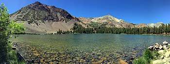
 Virginia Lakes from near the Sierra Crest | |
| Floor elevation | 9,819 ft (2,993 m)[1] |
| Geography | |
| Coordinates | 38°02′53″N 119°15′55″W |
| Rivers | Virginia Creek |
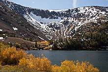
Black Mountain, over Upper Virginia Lake, Virginia Lakes, California
Upper Virginia Lake, Virginia Lakes
Features
Located in the Virginia Lakes area are a resort,[2] pack station,[3] and small community. Virginia Lakes is popular with anglers, hikers, and campers. A trail beginning at Virginia Lakes serves as a gateway to the Sierra backcountry and Yosemite National Park.[4]
See also
- List of lakes in California
References
- "Virginia Lakes". Geographic Names Information System. United States Geological Survey.
- "Virginia Lakes Resort".
- "Virginia Lakes Pack Outfit".
- "Hiking Trails". Virginia Lakes Resort.
- "Favorite Local Trails Around Virginia Lakes" (PDF). www.monocounty.ca.gov. Retrieved 15 November 2015.
- Erdman, James. "Eastern Sierra Back Country Fishing Guide" (PDF). www.fs.usda.gov. California Department of Fish & Game. Retrieved 15 November 2015.
This article is issued from Wikipedia. The text is licensed under Creative Commons - Attribution - Sharealike. Additional terms may apply for the media files.