Vics Peak Fire
Vics Peak Fire is a wildfire currently burning in the Apache Kid Wilderness in the Cibola National Forest in New Mexico, United States. First reported on June 15, 2020, the fire was started by a lightning strike. As of July 15, the fire has burned 14,624 acres (5,918 ha) and is 53 percent contained. The fire threatens private property, utilities infrastructure, and natural resources in the area, including the habitat of the Mexican spotted owl. It has also impacted recreational activities in the area due to trail and campground closures.
| Vics Peak Fire | |
|---|---|
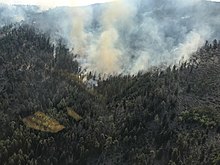
 Vics Peak Fire on July 12, 2020 | |
| Location | Apache Kid Wilderness, Cibola National Forest, New Mexico, United States |
| Coordinates | 33.57°N 107.442°W |
| Statistics[1] | |
| Date(s) | June 15, 2020– |
| Burned area | 14,624 acres (5,918 ha) |
| Cause | Lightning strike |
| Map | |
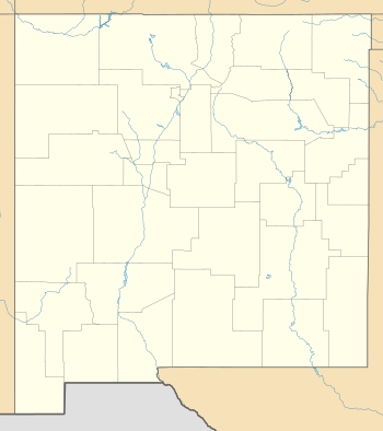
 Location in New Mexico | |
Events
June
The Vics Peak Fire was first reported burning in a remote area of the Apache Kid Wilderness in Cibola National Forest on June 15, 2020. Started by a lightning strike, the fire grew moderately and was monitored by fire crews. However, on June 18, unexpected fire behavior caused the fire to grow in size and two days later it had burned 2,827 acres (1,144 ha). Fueled by mixed conifer, ponderosa pine, pinyon-juniper and mahogany, smoke was visible from Interstate 40, Highway 1, and Highway 107. A temporary flight restriction was put in place over the fire. Forest Road 225 and trails leading into Apache Kid Wilderness were closed.[2]
By the morning of June 23, the fire had grown to 7,023 acres (2,842 ha).[3] However, the next day, accurate mapping led to the acreage to be re-evaluated at 6,729 acres (2,723 ha). The fire also had its first day of partial containment at 5 percent.[4] In addition to the trails, two campgrounds were closed.[5] Medical screening and decontamination team were placed near all crew camps to support firefighters general health and to monitor for COVID-19. The temporary flight restriction was expanded from five miles to 10 miles on June 26.[6] The next day, crews began work to protect nesting sites for the Mexican spotting owls, which are on the endangered species list.[7] The fires containment declined to three percent as the fire grew to 9,293 acres (3,761 ha).[8] As of June 30, the fire had burned 9,924 acres (4,016 ha) and is three percent contained.[9]
July
The fire had burned 10,624 acres (4,299 ha) by July 1, 2020 and was 18 percent contained.[10] The next day, fire officials stated that the threat of the fire growing had "slowed dramatically" and clean up continued.[11]
By July 11, it had been 50 percent contained. The fire moved between Milo Canyon and Smith Canyon, backing slowly into San Mateo Canyon. Additionally, fire progressed north from West Blue and Teepee Peak Mountains, in the 1994 Coffee Pot Fire footprint.[12]
As of July 15, 2020, Vics Peak Fire has burned 14,624 acres (5,918 ha) and is 53 percent contained.[1] Two days later, a monsoon entered the area, bringing moisture and concerns about flash floods.[13] On July 16, crews started the Burn Area Emergency Response post-fire assessment.[14]
Post-fire
According to the Burn Area Emergency Response (BAER) post-fire assessment, approximately 65 percent of the acreage in the fire's footprint was unburned or had low burn severity; 27 percent sustained moderate burn severity; and 2 percent suffered high burn severity. Six percent was unable to be classified at that time.[14]
Current evacuations and closures
As of July 13, 2020, the following roads, campgrounds and trails are closed:[15]
- Forest Road 225
- Springtime Campground
- Luna Park Campground
- Apache Kid Trail
- Cold Spring Trail
- Coffee Pot Trail
- Cowboy Trail
- Drift Fence Trail
- Indian Creek Trail
- Maverick Trail
- Milo Trail
- Nave Trail
- Post Trail
- San Mateo Trail
- Shipman Trail
- Skeleton Ridge Trail
- Smith Trail
- Teepee Peak Trail
A ten mile temporary flight restriction is in place over the fire.[10]
Impact
The fire is impacting recreational activities in the Apache Kid Wilderness. Upon the fire's growth on June 19, trails into the wilderness and two campgrounds were closed.[2] The fire threatens habitat for the threatened Mexican spotted owl.[16] To support the owls, crews protected nesting sites from stand-replacing fire.[7] It also threatens the San Mateo Lookout and Pankey Mine.[17]
While fighting the fire, crews improved existing Forest Roads in the fire region to improve driving conditions.[6]
Flash flooding remains a concern in the area.[14]
References
![]()
- "Vics Peak Fire Information - InciWeb the Incident Information System". InciWeb. Retrieved 30 June 2020.
- "Vics Peak Fire Burning in Apache Kid Wilderness" (PDF). ABQ Zone. InciWeb. Retrieved 1 July 2020.
- "Thunderstorms Expected Today Over Vics Peak Fire" (PDF). InciWeb. ABQ Zone. 23 June 2020. Retrieved 1 July 2020.
- "Suppression Strategy on Vics Peak Fire Focused on Safety" (PDF). InciWeb. ABQ Zone. 24 June 2020. Retrieved 1 July 2020.
- "Red Canyon Roads Provide Opportunity for Northern Containment of Vics Peak Fire" (PDF). InciWeb. ABQ Zone. 25 June 2020. Retrieved 1 July 2020.
- "Firefighters Vigilant as Dry Thunderstorms Continue Over Vics Peak Fire" (PDF). InciWeb. AB. 26 June 2020. Retrieved 1 July 2020.
- "Elevated Fire Weather May Increase Activity on Vics Peak Fire Today" (PDF). InciWeb. ABQ Zone. 27 June 2020. Retrieved 1 July 2020.
- "Specialists Improve Weather and Fire Behavior Predictions on Vics Peak Fire" (PDF). InciWeb. ABQ Zone. 29 June 2020. Retrieved 1 July 2020.
- "Vics Peak Fire 3% Contained, Uptick in Fire Activity from Recent Weather" (PDF). InciWeb. ABQ Zone. 30 June 2020. Retrieved 1 July 2020.
- "Vics Peak Fire 18% Contained, Holds Through Critical Fire Weather July 1, 2020 Update" (PDF). InciWeb. ABQ Zone. 1 July 2020. Retrieved 7 July 2020.
- "Containment Climbs as Moisture Moves in on Vics Peak Fire July 2, 2020 Update" (PDF). InciWeb. ABQ Zone. Retrieved 7 July 2020.
- "Vics Peak Fire at 50% Containment - InciWeb the Incident Information System". InciWeb. 11 July 2020. Retrieved 13 July 2020.
- "Monsoons Predicted Over Vics Peak Fire - InciWeb the Incident Information System". InciWeb. Retrieved 17 July 2020.
- "Vics Peak Fire Burn Area Emergency Response (BAER) Post-Fire Assessment - InciWeb the Incident Information System". InciWeb. Retrieved 17 July 2020.
- "Moisture Forecast for Vics Peak Fire - InciWeb the Incident Information System". InciWeb. 13 July 2020. Retrieved 14 July 2020.
- "Area Closures Planned for Vics Peak Fire Today" (PDF). InciWeb. ABQ Zone. 21 June 2020. Retrieved 1 July 2020.
- "Weather Conditions Cooperate for Aerial Ignitions on Vics Peak Fire" (PDF). InciWeb. ABQ Zone. 22 June 2020. Retrieved 1 July 2020.