Uptown Charlotte
Uptown Charlotte is the central business district of Charlotte, North Carolina. The area is split into four neighborhoods (wards) by the intersection of Trade and Tryon Streets, and bordered by Interstate 277 and Interstate 77. Uptown Charlotte is the largest business district in Charlotte and the Carolinas.
Uptown Charlotte | |
|---|---|
Neighborhood of Charlotte, North Carolina | |
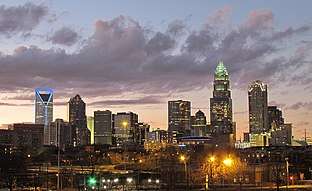 Uptown Charlotte skyline in 2011 | |
| Nickname(s): Historic Downtown / Uptown | |
| State | North Carolina |
| County | Mecklenburg |
| City | Charlotte |
| Council districts | 1, 2 |
| Neighborhood Profile Areas (NPA) | 340, 341, 342, 384 |
| Area | |
| • Total | 5.5 km2 (2.14 sq mi) |
| Population (2018)[1] | |
| • Total | 30,000 |
| • Density | 5,400/km2 (14,000/sq mi) |
| Zip Code | 28202, 28204, 28206, 28208 |
| Area code(s) | 704, 980 |
| Website | www.CharlotteCenterCity.org |
| Quality of Life Dashboard | |
Several Fortune 500 companies have their headquarters in the district, including Bank of America, Duke Energy, Honeywell, and the east coast operations of Wells Fargo. Uptown contains over 28 million square feet of office space. Athletic and event facilities located in Center City include Bank of America Stadium, Spectrum Center, BB&T Ballpark, and the NASCAR Hall of Fame. Museums, theaters, hotels, high-density residential developments, restaurants, and bars are heavily concentrated in the Center City, with over 214 restaurants and 50 nightspots.[2]
Origins
Charlotte's central business district is referred to as "Uptown" by locals, although the term "Downtown" is understood and used by native Charlotteans since it references the same area of the city. There is some confusion brought about by the use of the terms "Uptown" and "Downtown" for Charlotte's center city area. The term "Up-Town" referring to the geographic location of Tryon and Trade Street, “uptown” actually does sit at a higher elevation than the rest of the city, was recorded as early as 1895 in the Charlotte Observer but fell out of use around 1929 for reasons unknown. The term "Downtown" was commonly used up until the mid-1970s by residents, media, and city leaders for the Center City. In 1973, a massive campaign was launched by local businessman Jack Wood to revamp the image of the downtown area and embrace the historic and arguably uniquely Charlotte term "Uptown" by reintroducing it to the general public. In September 1974 Charlotte City Council passed an official proclamation that said "The heart of Charlotte should be now and forever more known as Uptown Charlotte."[3] On February 14, 1987, the Charlotte Observer began using the term "Uptown" as a way to promote a more positive upbeat image of the Center City area.[4] School teachers were provided with "historical" documents justifying use of the term to teach to students.[5]
Major streets
Tryon Street

Tryon Street is a major north–south street of Charlotte, North Carolina. It traverses through the center of Uptown Charlotte and is the address for some of the city's tallest buildings, such as the Bank of America Corporate Center and Hearst Tower. U.S. Route 29 and North Carolina Highway 49 are signed along portions of Tryon Street (although they both deviate onto Graham Street through Uptown). The road is divided into two segments at its intersection with Trade Street: North Tryon Street and South Tryon Street. Likewise, Tryon Street divides Trade Street into east and west. The Trade and Tryon intersection serves as the dividing point for the city's first four wards, as well as the center of its address grid. The street was named after William Tryon, governor of the Province of North Carolina from 1765 to 1771.
Entering the Charlotte city limits from the north, US 29's street name changes from Concord Parkway to North Tryon Street. US 29 and Tryon Street continue southwest through the University City neighborhood, passing by the Verizon Wireless Amphitheater Charlotte, intersecting with Interstate 485 (North Carolina), and passing through the University of North Carolina at Charlotte, where NC 49 joins in from University City Boulevard.
South Tryon Street terminates at the Charlotte city limits at the Steele Creek neighborhood, where it changes to York Road. NC 49 continues west to Lake Wylie, South Carolina, where it becomes Charlotte Highway and SC 49 begins.
Building which have a Tryon Street address include:
Trade Street
Trade Street is the major east–west street that divides the northern and southern wards in the city of Charlotte, North Carolina. The following towers have a Trade Street address:
College Street
Building which have a College Street address include:
Neighborhoods
Uptown Charlotte is divided into four neighborhoods, or "wards", by the intersection of Trade and Tryon Streets.[6]
First Ward

First Ward lies directly to the east of the intersection of Trade and Tryon. It is that quadrant bounded by North Tryon on the northwest and East Trade on the southwest.
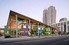
Once considered one of the most dangerous areas in Charlotte, the first ward has become one of the more desirable because of revitalization under a HUD HOPE VI grants with many new developments are under construction. The award-winning Center City Building which houses the uptown campus of the University of North Carolina at Charlotte is in the first ward. The Center City Building is part of an urban village project being developed by Levine Properties. The urban village includes a 4-acre (16,000 m2) park, which was completed in December 2015, 450,000 sq ft (42,000 m2) of office space, 2,700 residential units, 250 hotel rooms, 250,000 sq ft (23,000 m2) of retail space, and 450,000 sq ft (42,000 m2) of civic space. Current attractions include the Main Library, the Spirit Square portion of the North Carolina Blumenthal Performing Arts Center, ImaginOn Children's Learning Center, Levine Museum of the New South, the Spectrum Center (home of the Charlotte Hornets). On Tryon at Sixth Street, one of Charlotte's historic buildings is being preserved and connected to a new condo project called "Encore."
.jpg)
Second Ward
The second ward lies directly to the south of the intersection of Trade and Tryon. It is the quadrant bounded by South Tryon on the northwest and East Trade on the northeast.
It is the location of Charlotte's "Government District" and is the site of the NASCAR Hall of Fame. The second ward was formerly the location of the predominantly black neighborhood, Brooklyn, before an urban renewal project took place. Today, second ward is home to the EpiCentre, a mixed-use entertainment and retail complex; the Charlotte Convention Center; the Victorian Gothic style St. Peter's Catholic Church; The Green, a downtown mini-park; and the Harvey B. Gantt Center for African-American Art+Culture. Duke Energy also has its corporate headquarters in the second ward.
Third Ward

The third ward lies directly to the west of the intersection of Trade and Tryon. It is the quadrant bounded by South Tryon on the southeast and West Trade on the northeast. It is the location of the Knight Theatre, the Mint Museum, and the Bechtler Museum of Modern Art.
Uptown's third ward is a diverse "streetcar neighborhood," home to the Carolina Panthers' Bank of America Stadium and Gateway Village. Gateway Village, one of the state's largest mixed-use developments, is 1.5 million sq ft (140,000 m2) in size, and home to offices, shops, restaurants, entertainment venues and over 500 housing units.[7] Johnson & Wales University's Charlotte campus is located directly across from Gateway Village, with Johnson C. Smith University's campus located adjacent. Third ward is also the site of the upcoming $800.1 million Gateway Station transportation hub, which began construction in July 2018. The Gateway Station will house a Greyhound bus stop, an Amtrak station, the LYNX Red Line and LYNX Silver Line, and a CATS bus hub.
BB&T Ballpark, home of the Charlotte Knights, opened in 2014. Directly across the street is Romare Bearden Park, which opened in September 2013.
Fourth Ward
The fourth ward lies directly to the north of the intersection of Trade and Tryon. It is that quadrant bounded by North Tryon on the southeast and West Trade on the southwest.
It is mostly residential and has many stately Victorian homes. It is an official historic district, and is the location of Old Settlers' Cemetery and the three-acre Fourth Ward Park.
Economy
Uptown Charlotte (including South End) employs 130,000 people, hosts more than 18 million visitors a year, and is home to 30,000 residents.[8]
Companies with headquarters in Uptown
- Bank of America
- Truist Financial
- Wells Fargo East Coast operations
- Duke Energy
- Barings
- Honeywell
- Passport
- AvidxChange
Companies with large corporate presence in Uptown
Education
Colleges and universities
- Johnson and Wales University, Charlotte campus
- University of North Carolina at Charlotte, Uptown campus
- Johnson C. Smith University
- Central Piedmont Community College
Libraries
Charlotte Center City is served by two branches of the Public Library of Charlotte and Mecklenburg County now known as Charlotte Mecklenburg Library. The Main library is located on North Tryon Street.[9] In November 2019, new designs for the $100 million, 115,000-square-foot Main Library in Uptown Charlotte were revealed. The organization is planning to break ground in 2021 and complete the build in early 2024.[10]
ImaginOn: The Joe and Joan Martin Center is located on east Seventh Street.[11] ImaginOn is a collaborative venture of Charlotte Mecklenburg Library and the Children's Theater of Charlotte. The library provides services, books, CDs, DVDs and homework support for children and teens. ImaginOn contains the McColl Family Theatre and the Wachovia Playhouse, venues used by the Children's Theater for their performances.
Parks, recreation, and culture
Parks
- Romare Bearden Park
- First Ward Park
- Fourth Ward Park
- The Green
- Marshall Park
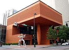
Entertainment venues
.jpg)
Uptown Charlotte has three major league sports venues. Bank of America Stadium, home of the Carolina Panthers, opened in 1996, the Spectrum Center, home of the Charlotte Hornets, opened in 2005, and the American Legion Memorial Stadium, home of the Charlotte Hounds. The Charlotte Knights, a minor league baseball team, also plays at BB&T Ballpark.
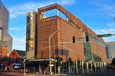
The Charlotte Convention Center attracts over 500,000 people a year to its 280,000 square feet (26,000 m2) of exhibit space. The Convention Center is currently undergoing an expansion to add an additional 50,000 square feet (4,600 m2) of meeting space and a pedestrian bridge connection to the adjacent Westin hotel.
Within recent years, multiple museums have opened in Uptown. The first phase of the Levine Center for the Arts opened in 2010, as part of the then-named Wachovia Cultural Campus. List of museums in Uptown:
- Bechtler Museum of Modern Art
- Billy Graham Library
- Carolinas Aviation Museum
- Charlotte-Mecklenburg Fire Education Center and Museum
- Charlotte Nature Museum in Freedom Park
- Charlotte Trolley Museum in Historic South End
- Discovery Place
- Discovery Place KIDS-Huntersville
- Harvey B. Gantt Center for African-American Arts + Culture
- Historic Rosedale Plantation
- Levine Museum of the New South
- The Light Factory
- McColl Center for Art + Innovation
- Mint Museum
- NASCAR Hall of Fame
- Second Ward Alumni House Museum
- Wells Fargo History Museum
- Charlotte Museum of History
- AvidxChange Music Factory
Hotels and accommodations
List of major hotels in Uptown Charlotte:
- The Westin Charlotte
- The Ritz Carlton Charlotte
- Hyatt House
- Grand Bohemian Charlotte
- Hilton Charlotte
- Embassy Suites
- Omni Hotel
- Residence Inn by Marriott
- Residence Inn by Marriott at Epicentre
- Marriott Charlotte
- Courtyard by Marriott
- Hampton Inn
- SpringHill Suites
- Kimpton Tryon Park Hotel
- DoubleTree
- Aloft
- Crowne Plaza
- Holiday Inn
- Hilton Garden Inn
- AC Hotel/Residence Inn Charlotte EpiCentre
- InterContinental Hotel (under construction)
- JW Marriott (under construction)
- Homewood Suites by Hilton (under construction)
Transportation
Uptown Charlotte is surrounded by Interstate 277, an auxiliary highway which creates the boundaries of the four wards and is the innermost of the city's three ring roads. Interstate 77 also runs parallel to the west of Uptown's third and fourth wards. The Lynx Blue Line runs through Uptown, connecting Uptown to Charlotte's University City to the east and Interstate 485 to the west via light rail.
References
- "2018 State of the Center City" (PDF). Charlotte Center City Partners. Charlotte Center City Partners. Retrieved 7 April 2018.
- http://www.bizjournals.com/charlotte/blog/queen_city_agenda/2014/02/retail-office-towers-hotels-top-uptown-charlottes.html?page=2
- http://www.wfae.org/post/faq-city-why-downtown-charlotte-called-uptown#stream/0
- "Charlotte-Mecklenburg Story: History Timeline: 'Down' Becomes 'Up'". cmstory.org Web Site. Public Library of Charlotte and Mecklenburg County. Retrieved 2015-09-28.
- [ Proclamation Designating Central Shopping and Business District as 'Uptown Charlotte' ] by City of Charlotte Mayor John M. Belk; September 23, 1974; Note:This claim needs a reliable source and link
- "Charlotte Center City Map – 4 Wards".
- "Post Gateway Apartments: Charlotte Community & Amenities". www.postproperties.com. Retrieved 2016-03-28.
- "2018 State of the Center City" (PDF). Charlotte Center City Partners. Charlotte Center City Partners. Retrieved 7 April 2018.
- "The Main Library of the Public Library of Charlotte and Mecklenburg County". Retrieved 2008-10-25.
- "Future of Main Library | Charlotte Mecklenburg Library". www.cmlibrary.org. Retrieved 2020-04-22.
- "ImaginOn: The Joe and Joan Martin Center". Retrieved 2008-10-25.
External links
Official websites
- Official website Charlotte Center City
- Living Uptown Charlotte