Uganik, Alaska
Uganik is a community in the Kodiak Island Borough of the U.S. state of Alaska.[1] Other variations of the name that have been reported are Oohanick in 1805, Ooganok in the 1880 Census (population 73), and Uganak in the 1890 Census (population 31).[2]
Uganik is located on the north coast of Kodiak Island, at the west shore of the northeast arm of Uganik Bay.[2][3] Its coordinates are 57°46′N 153°24′W and its elevation is 0 feet (0 m).[1]
The community is served by the San Juan (Uganik) Seaplane Base,[4] which has scheduled passenger service subsidized by the U.S. Essential Air Service program.[5]
| Climate data for Uganik, Alaska | |||||||||||||
|---|---|---|---|---|---|---|---|---|---|---|---|---|---|
| Month | Jan | Feb | Mar | Apr | May | Jun | Jul | Aug | Sep | Oct | Nov | Dec | Year |
| Record high °F (°C) | 52 (11) |
50 (10) |
57 (14) |
58 (14) |
70 (21) |
82 (28) |
85 (29) |
77 (25) |
72 (22) |
64 (18) |
54 (12) |
53 (12) |
85 (29) |
| Average high °F (°C) | 35.7 (2.1) |
36.9 (2.7) |
39.0 (3.9) |
44.0 (6.7) |
52.8 (11.6) |
60.9 (16.1) |
64.4 (18.0) |
64.6 (18.1) |
56.9 (13.8) |
47.5 (8.6) |
40.2 (4.6) |
33.8 (1.0) |
48.1 (8.9) |
| Daily mean °F (°C) | 30.0 (−1.1) |
30.3 (−0.9) |
32.0 (0.0) |
36.7 (2.6) |
44.2 (6.8) |
51.6 (10.9) |
55.8 (13.2) |
56.5 (13.6) |
49.7 (9.8) |
40.4 (4.7) |
34.1 (1.2) |
27.9 (−2.3) |
40.8 (4.9) |
| Average low °F (°C) | 24.2 (−4.3) |
23.7 (−4.6) |
25.0 (−3.9) |
29.4 (−1.4) |
35.6 (2.0) |
42.3 (5.7) |
47.2 (8.4) |
48.3 (9.1) |
42.5 (5.8) |
33.2 (0.7) |
27.9 (−2.3) |
22.0 (−5.6) |
33.4 (0.8) |
| Record low °F (°C) | 3 (−16) |
1 (−17) |
3 (−16) |
11 (−12) |
21 (−6) |
25 (−4) |
36 (2) |
34 (1) |
27 (−3) |
13 (−11) |
1 (−17) |
−3 (−19) |
−3 (−19) |
| Average precipitation inches (mm) | 4.09 (104) |
3.02 (77) |
2.94 (75) |
3.31 (84) |
2.75 (70) |
1.76 (45) |
2.12 (54) |
1.81 (46) |
3.81 (97) |
6.42 (163) |
5.94 (151) |
4.61 (117) |
42.58 (1,083) |
| Average snowfall inches (cm) | 13.8 (35) |
7.7 (20) |
9.4 (24) |
3.4 (8.6) |
0.0 (0.0) |
0.0 (0.0) |
0.0 (0.0) |
0.0 (0.0) |
0.1 (0.25) |
1.7 (4.3) |
3.2 (8.1) |
12.1 (31) |
51.4 (131.25) |
| Source: WRCC [6] | |||||||||||||
References
- "Feature Detail Report for: Uganik (populated place)". Geographic Names Information System. United States Geological Survey. March 23, 2001.
- Orth, Donald J. Dictionary of Alaska Place Names. Washington, DC
- "Topographic map showing location of Uganik". The National Map. United States Geological Survey (via MSR Maps). July 1, 1979.
- "Airport information for WSJ: SAN JUAN /UGANIK/". Federal Aviation Administration. Retrieved June 9, 2014.
- "Order 2013-9-12". U.S. Department of Transportation. September 20, 2013.
re-selecting Redemption Inc., d/b/a Island Air Service, to provide Essential Air Service (EAS) at Alitak, Amook Bay, Kitoi Bay, Moser Bay, Olga Bay, Port Bailey, Port Williams, Seal Bay, Uganik, West Point, and Zachar Bay, Alaska
- Uganik Bay, Alaska - Period of Record : 8/5/1951 to 3/31/1965 Archived 2017-05-09 at the Wayback Machine. Retrieved November 15, 2019.
Municipalities and communities of Kodiak Island Borough, Alaska, United States | ||
|---|---|---|
Borough seat: Kodiak | ||
| Cities | 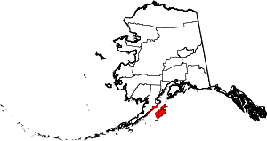 Kodiak Island Borough map | |
| CDPs | ||
| Ghost towns | ||
This article is issued from Wikipedia. The text is licensed under Creative Commons - Attribution - Sharealike. Additional terms may apply for the media files.