U.S. Route 60 in Illinois
U.S. Route 60 and U.S. Route 62 (US 60/US 62) run for a very short distance within the state of Illinois. The highways run concurrently for their entire existence within the state. The joint highway runs around Fort Defiance in Cairo, from the Cairo Mississippi River Bridge over the Mississippi River east to the Cairo Ohio River Bridge over the Ohio River; the Ohio River Bridge also carries US 51. The bridges cross the two rivers just north of the mouth of the Ohio.
| |||||||
|---|---|---|---|---|---|---|---|
| Ohio River Scenic Byway | |||||||

US 60 / US 62 highlighted in red | |||||||
| Route information | |||||||
| Maintained by IDOT | |||||||
| Length | 0.92 mi[1] (1.48 km) | ||||||
| Major junctions | |||||||
| West end | |||||||
| East end | |||||||
| Location | |||||||
| Counties | Alexander | ||||||
| Highway system | |||||||
| |||||||

Route description

US 60/US 62 enters Illinois via the Cairo Mississippi River Bridge, a narrow, through truss bridge.[2] The bridge deposits the highway onto a viaduct which rises above farmland in the alluvial plain. At the northern end of the causeway is the entrance to Fort Defiance Park, a former Civil War military post and later state park. Fort Defiance marks the confluence of the Mississippi and Ohio Rivers and Illinois' southernmost and lowest points. The lone intersection for US 60/US 62 is with US 51, which joins from the north. The three highway designations come together to head northeast and rise onto the Cairo Ohio River Bridge and into Kentucky.[3][4]
The Great River Road's National Route overlaps US 60/US 62 from the intersection with US 51 to the Kentucky state line.
History
Until the Mississippi River Bridge opened c. 1929, US 60 used a ferry directly from Bird's Point, Missouri, across that river (below the Ohio) to Wickliffe, Kentucky.[5] After that it ran into Cairo and used a ferry from roughly 22nd Street to East Cairo, Kentucky.[6] US 62 was designated around 1930, and the Ohio River Bridge replaced the ferry in 1937.
Originally, the Mississippi River bridge opened in 1929. It was a boon to economies of Southeast Missouri and Northern Arkansas.[7] The toll drivers would have had to pay on the Mississippi bridge was $1.40 (equivalent to $21.43 in 2019[8]).[9]
Meanwhile, the Ohio River bridge was delayed. An Act of Congress gave them more time.[10] It was eventually dedicated on November 11, 1938, and made toll free exactly ten years later. It had a cost of $3 million (equivalent to $42.9 million in 2018[11]).[12]
Major intersections
The entire route is in Cairo, Alexander County.
| mi[1] | km | Destinations | Notes | ||
|---|---|---|---|---|---|
| 0.00– 0.55 | 0.00– 0.89 | Continuation into Missouri | |||
| Cairo Mississippi River Bridge; Missouri–Illinois state line | |||||
| 0.72 | 1.16 | Western end of US 51 and Great River Road overlaps | |||
| 0.75– 0.92 | 1.21– 1.48 | Cairo Ohio River Bridge; Illinois–Kentucky state line | |||
| Continuation into Kentucky | |||||
1.000 mi = 1.609 km; 1.000 km = 0.621 mi
| |||||
References
- "Illinois Technology Transfer Center". Illinois Department of Transportation. 2013. Archived from the original (ESRI shapefile) on June 26, 2013. Retrieved July 27, 2014.
- Federal Highway Administration (2012). "NBI Structure Number: 000002000500887". National Bridge Inventory. Federal Highway Administration.
- Federal Highway Administration (2012). "NBI Structure Number: 000002000600888". National Bridge Inventory. Federal Highway Administration.
- Google (January 14, 2015). "Overview Map of US 60/US 62 in Illinois" (Map). Google Maps. Google. Retrieved January 14, 2015.
- "United States Numbered Highways". American Highways. April 1927.
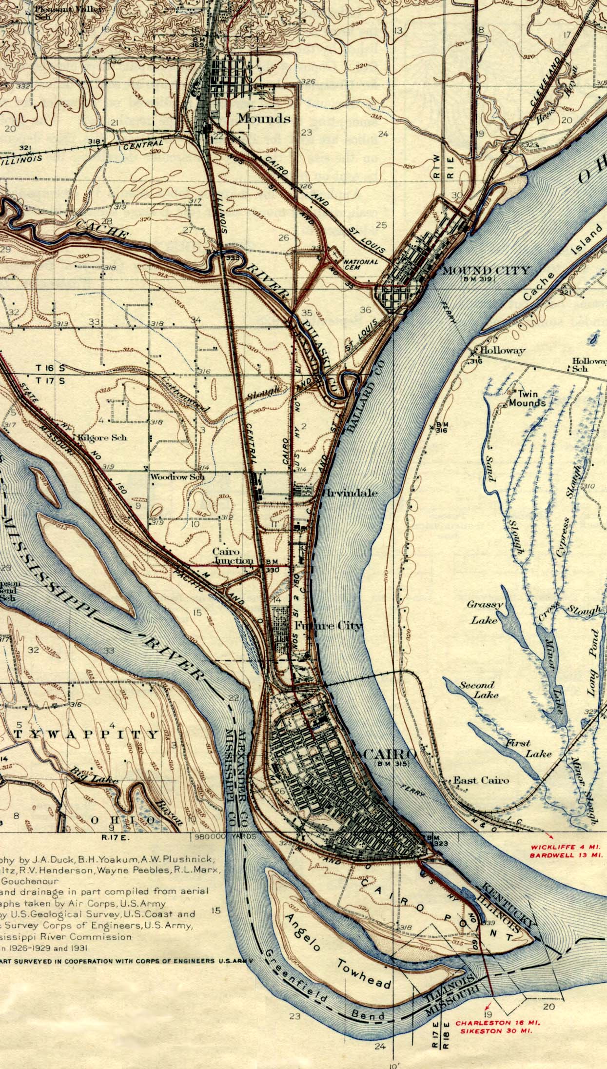
- United States Geological Survey (1939). Cairo (Map). Scale not given. Reston, VA: United States Geological Survey. Retrieved July 13, 2008 – via University of Texas Libraries.
- Cairo citizen (November 10, 1931). "Is the Bridge a Benefit?". The Daily Free Press. Carbondale, IL. p. 2. Retrieved January 14, 2015 – via Newspapers.com.

- Federal Reserve Bank of Minneapolis. "Consumer Price Index (estimate) 1800–". Retrieved January 1, 2020.
- Mr. Hughes (March 20, 1931). "Krauses Enjoy Texas Vacation; Visit L. Wayman". Arlington Heights Herald. p. 5. Retrieved January 14, 2015 – via Newspapers.com.
- "From Far and Near". The Jacksonville Daily Journal. February 4, 1931. p. 1. Retrieved January 14, 2015 – via Newspapers.com.
- Thomas, Ryland; Williamson, Samuel H. (2019). "What Was the U.S. GDP Then?". MeasuringWorth. Retrieved April 6, 2019. United States Gross Domestic Product deflator figures follow the Measuring Worth series.
- "Ohio River Bridge at Cairo Made Toll Free". Alton Evening Telegraph. Associated Press. November 12, 1948. p. 1. Retrieved January 14, 2015 – via Newspapers.com.
External links
- Fort Defiance Illinois. Miss and Ohio Rivers on YouTube
- Visitors Guide to the Fort Defiance Park at Greatriverroad.com
| Previous state: Missouri |
Illinois | Next state: Kentucky |
| Previous state: Missouri |
Illinois | Next state: Kentucky |