Transportation in Greater Los Angeles
Greater Los Angeles has a complex multimodal transportation infrastructure, which serves as a regional, national and international hub for passenger and freight traffic. The transportation system of Greater Los Angeles includes the United States' largest port complex, seven commuter rail lines, Amtrak service, a subway system within the city of Los Angeles, and numerous highways. Los Angeles is integrated into the Interstate Highway System by Interstate 5, Interstate 10, and Interstate 15, along with numerous auxiliary highways and state routes. Bus service is also included locally within the area by numerous local government agencies. Subways and light commuter rail lines are present within Los Angeles proper, allowing mass transportation within the city. Commuter railroads are run by Metrolink. Amtrak has numerous railroad lines that connect Los Angeles to the rest of the country.

People in Los Angeles rely on cars as the dominant mode of transportation, [1] but starting in 1990 Los Angeles Metro Rail has built over one hundred miles (160 km) of light and heavy rail serving more and more parts of Los Angeles.
Rail
Local Rail Services
Metrolink
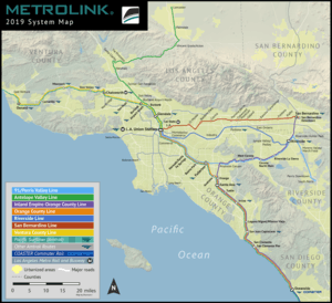
As Greater Los Angeles' main commuter rail service, Metrolink runs seven lines through Southern California.
- 91 Line (61.6 mile route between Union Station and Riverside-Downtown)
- Antelope Valley Line (76.6 mile route between Union Station and Lancaster)
- Inland Empire-Orange County (IEOC) Line (100.1 mile route between San Bernardino and Oceanside)
- Orange County Line (87.2 mile route between Union Station and Oceanside)
- Riverside Line (59.1 mile route between Union Station and Riverside-Downtown)
- San Bernardino Line (61.5 mile route between Union Station and San Bernardino/Riverside-Downtown)
- Ventura County Line (70.9 mile route between Union Station and Montalvo, Ventura)
Los Angeles County Metro Rail
The Los Angeles County Metro Rail is a light rail and subway system that serves primarily Los Angeles and its surrounding cities. There are several routes associated to this system, which follows:
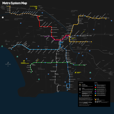
The Los Angeles County Metropolitan Transportation Authority (Metro) runs six rail lines throughout Los Angeles County.
- The Metro A Line (opened in 1990 as the Blue Line) is a light rail line running between 7th Street/Metro Center station in Downtown Los Angeles and Transit Mall station in Downtown Long Beach. It is the first of the MTA's modern rail lines since the 1961 demise of the Pacific Electric Railway's Red Car system.
- The Metro B Line is a subway line running between Union Station in Downtown Los Angeles and North Hollywood station in North Hollywood. The first leg opened as the Red Line to Westlake / MacArthur Park in 1993, to Hollywood in 1999, and to North Hollywood in 2000.
- The Metro C Line (opened in 1995 as the Green Line) is a light rail line running between Marine/Redondo station in the South Bay region of Los Angeles and the Norwalk station in Norwalk. The line operates mostly in the median of the Century Freeway (Interstate 105). It offers indirect access to Los Angeles International Airport via a shuttle bus from the Aviation/I-105 station. It is the region's only above-ground light rail line that is completely grade separated.
- The Metro L Line (opened in 2003 as the Gold Line) is a light rail line that runs between Union Station in Downtown Los Angeles and Sierra Madre Villa station in Pasadena and runs through Highland Park and South Pasadena. Portions run elevated, below ground, in city streets, and in the median of a freeway.
- The Metro D Line (named the Purple Line in 2006; first leg to Westlake/MacArthur Park opened in 1993; to Koreatown in 1996) is a subway line running between Union Station in Downtown Los Angeles and Wilshire/Western station in the Koreatown neighborhood of Los Angeles Mid-Wilshire district. It was considered a branch of the Red Line prior to 2006.
- The Metro E Line Line (opened in 2013 as the Expo Line) is a light rail line running between Los Angeles and Santa Monica.
Linking Rail Services
Amtrak California Pacific Surfliner
The Pacific Surfliner is a 350-mile (563 km) Amtrak passenger train route serving communities on the coast of Southern California between San Diego and San Luis Obispo.
Amtrak Coast Starlight
The Coast Starlight is a 1,389-mile (2,235 km) passenger train route operated by Amtrak on the West Coast of the United States. It runs from Seattle, Washington's King Street Station to Los Angeles, California's Union Station.
Amtrak Southwest Chief
The Southwest Chief (formerly the Southwest Limited) is a passenger train operated by Amtrak along a 2256-mile (3631-km) route through the Midwestern and Southwestern United States. It runs from Chicago, Illinois, to Los Angeles, California, passing through Illinois, Iowa, Missouri, Kansas, Colorado, New Mexico, Arizona, and California.
Amtrak Sunset Limited
The Sunset Limited is a passenger train that for most of its history has run between New Orleans and Los Angeles, California, and that from early 1993 through late August 2005 also ran east of New Orleans to Florida, making it during that time the only true transcontinental passenger train in American history (ignoring, of course, the comparatively small gaps between its endpoint stations and the respective seacoasts).
Amtrak Texas Eagle
The Texas Eagle is a 1306-mile (2102 km) passenger train route operated by Amtrak in the central and western United States. Trains run daily between Chicago, Illinois, and San Antonio, Texas, and continue to Los Angeles, California, 2728 miles (4390 km) total, three days a week (incorporated as part of the Sunset Limited).
Bus
Buses in the Greater Los Angeles is serviced by several governmental entities, mostly notable Los Angeles County Metropolitan Transportation Authority (also known as Metro, MTA or LACMTA), Orange County Transportation Authority (OCTA), Riverside Transit Agency, OmniTrans (San Bernardino County), Santa Barbara MTD and South Coast Area Transit (Ventura County).
Road
Public roads
The Greater Los Angeles area operates on a very extensive network of public roadways that allows vehicle drivers convenient direct access to all practical destinations in the area.
Major Freeways leading into and out of Greater Los Angeles Area
- Interstate 5 southbound to Tijuana in Baja California, Mexico, northbound to the Central Valley
- John J. Montgomery Freeway from U.S.-Mexico border crossing at San Ysidro, California to Downtown San Diego
- San Diego Freeway from Downtown San Diego to the El Toro Y
- Santa Ana Freeway from the El Toro Y to the East L.A. Interchange
- Golden State Freeway from the East L.A. Interchange to Wheeler Ridge, California
- Interstate 10 west terminus at Santa Monica, California, eastbound to the Arizona State Line
- Santa Monica Freeway from Santa Monica, California to the East L.A. Interchange
- San Bernardino Freeway from the East L.A. Interchange to San Bernardino, California
- Interstate 15 south terminus in Barrio Logan in San Diego, northbound to the Nevada State Line
- Temecula Valley Freeway from the San Diego County Line to Lake Elsinore
- Corona Freeway from Lake Elsinore to Corona
- Ontario Freeway from Corona to Devore
- Mojave Freeway from Devore to the Nevada State Line
- Interstate 40 west terminus in Barstow, California, eastbound to the Arizona State Line
- Needles Freeway
- U.S. Route 101 south terminus at the East L.A. Interchange, westbound to Santa Barbara, California then northbound to the Central Coast of California
- Santa Ana Freeway from the East L.A. Interchange to the Four Level Interchange
- Hollywood Freeway from the Four Level Interchange to the junction with the Ventura Freeway
- Ventura Freeway from the junction with the Hollywood Freeway to Seacliff, California
- State Route 14, south terminus at the Newhall Pass Interchange, northbound to Bishop, California via U.S. Route 395
- Antelope Valley Freeway from the Newhall Pass Interchange to Mojave, California
Greater Los Angeles Freeways
- State Route 1
- freeway stub in Dana Point, leading north from Interstate 5
- freeway stub east of Oxnard
- State Route 2
- Glendale Freeway from Silver Lake to junction with State Route 134 in Glendale, California
- Frank D. Lanterman Freeway from junction with State Route 134 to La Cañada-Flintridge
- Interstate 5
- San Diego Freeway from San Diego to the El Toro Y in Irvine
- Santa Ana Freeway from the El Toro Y in Irvine to the East L.A. Interchange
- Golden State Freeway from the East L.A. Interchange to Wheeler Ridge, California in Kern County
- Interstate 10
- Santa Monica Freeway from Santa Monica to the East L.A. Interchange
- San Bernardino Freeway from the East L.A. Interchange to San Bernardino, California
- State Route 14
- Antelope Valley Freeway from Sylmar to Mojave, California in Kern County
- Interstate 15
- Temecula Valley Freeway from San Diego County line to Lake Elsinore
- Corona Freeway from Lake Elsinore to Corona
- Ontario Freeway from Corona to Devore
- Mojave Freeway from Devore to the Nevada State Line
- State Route 22
- 7th Street freeway stub from Long Beach, California to Los Alamitos, California at the Interstate 405 and Interstate 605 interchange
- Garden Grove Freeway from Westminster, California to Orange, California
- State Route 23
- Moorpark Freeway from Newberry Springs, California to Moorpark, California
- State Route 33
- Ojai Freeway from Ventura, California to Foster Park, California
- Interstate 40
- Needles Freeway from Barstow, California to the Arizona State Line
- State Route 47
- Vincent Thomas Bridge connecting San Pedro to Terminal Island
- Terminal Island Freeway from Seaside Ave to Henry Ford Ave exit (splitting off from State Route 103
- State Route 55
- Costa Mesa Freeway, formerly Newport Freeway from Costa Mesa to Anaheim
- State Route 57
- Orange Freeway from the Orange Crush interchange to San Dimas, California
- State Route 58
- freeway stub west from Barstow, California
- State Route 60
- Pomona Freeway from the East L.A. Interchange to Riverside, California
- Moreno Valley Freeway from Riverside, California to the junction with Interstate 10
- State Route 71
- Chino Valley Freeway from just north of State Route 91 to State Route 60
- freeway stub from the Kellogg Interchange leading to the Corona Expressway
- State Route 73
- State Route 90
- Marina Freeway freeway stub east and west of the Interstate 405 near Marina del Rey
- Richard M. Nixon Parkway freeway stub west from just north of State Route 91 in Yorba Linda
- State Route 91
- Gardena Freeway from Interstate 110 in Gardena to Artesia
- Artesia Freeway from Artesia to Fullerton at Interstate 5
- Riverside Freeway from Fullerton at Interstate 5 to Riverside, California
- U.S. Route 101
- Santa Ana Freeway from the East L.A. Interchange to the Four Level Interchange
- Hollywood Freeway from the Four Level Interchange to the junction with State Route 134 and State Route 170
- Ventura Freeway from the junction with State Route 134 and State Route 170 to Seacliff, California just west of Ventura
- State Route 103
- Terminal Island Freeway co-signed from Seaside Avenue with State Route 47 to Sepulveda Blvd/Willow Street in Long Beach
- Interstate 105
- Glenn Anderson Freeway, more commonly known as the Century Freeway from El Segundo to Norwalk
- Interstate 110
- Harbor Freeway from San Pedro, California to Downtown L.A. at the interchange with the Santa Monica Freeway
- State Route 110
- Harbor Freeway from the interchange with the Santa Monica Freeway to the Four Level Interchange
- Pasadena Freeway from the Four Level Interchange to Pasadena, California
- State Route 118
- Ronald Reagan Freeway, also known as the Simi Valley-San Fernando Valley Freeway, or more simply, the Simi Valley Freeway from Moorpark to San Fernando
- State Route 133
- Laguna Freeway from just south of Interstate 405 to Interstate 5
- Eastern Transportation Corridor from Interstate 5 to State Route 241
- State Route 134
- Ventura Freeway from the junction with the Hollywood Freeway in Universal City to Pasadena
- State Route 138
- freeway stub east from Interstate 5 near Gorman
- State Route 170
- Hollywood Freeway from the interchange with the Ventura Freeway to the Golden State Freeway
- Interstate 210 and State Route 210
- Interstate 215
- Escondido Freeway from Murrieta to Riverside
- Riverside Freeway from Riverside to San Bernardino
- Barstow Freeway from San Bernardino to Devore
- State Route 241
- Foothill Transportation Corridor from Oso Parkway to the Eastern Transportation Corridor
- Eastern Transportation Corridor from the Foothill Transportation Corridor to the Riverside Freeway
- State Route 261
- Eastern Transportation Corridor from Jamboree Road near the Santa Ana Freeway to State Route 241
- Interstate 405
- San Diego Freeway from the El Toro Y in Irvine to San Fernando
- Interstate 605
- San Gabriel River Freeway from Los Alamitos to Duarte
- Interstate 710
- Long Beach Freeway from Long Beach to Valley Blvd. in Alhambra
- freeway stub south from the Foothill Freeway (unsigned SR 710)
Air
The Greater Los Angeles Area is serviced by 4 major airports and several minor airports. Los Angeles International (LAX), while LA/Ontario International and John Wayne Airport serves as overflow to LAX. The region is also serviced by Long Beach Airport, Hollywood Burbank Airport, Palm Springs International Airport, San Bernardino International Airport, and Palmdale Airport.
Ferry
Santa Catalina Island is served by several ferry lines with regular daily service to Newport Beach, San Pedro, Long Beach, Marina del Rey, and Dana Point.
References
- Official Metrolink Web site
- Official Metro website
- Official Los Angeles International Airport site
- Official LA/Ontario International Airport site
- Official John Wayne Airport-Orange County site
- Amtrak
- Orange County Transportation Agency
See also
- Transportation of Los Angeles