Terres de l'Ebre
Terres de l'Ebre (Catalan pronunciation: [ˈtɛrəz ðə ˈleβɾə], literally in English 'The Ebre Lands') is one of the seven territories defined by the Regional Plan of Catalonia. It is located in the south-west of Catalonia, in the southern part of river Ebre, and will be formed by four comarques: Baix Ebre, Montsià, Terra Alta and Ribera d'Ebre.[1]
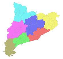
Catalan regional plan 1995.
- Àmbit metropolità
- Alt Pirineu i Aran
- Camp de Tarragona
- Comarques Centrals
- Comarques Gironines
- Ponent
- Terres de l'Ebre
The northern coastal limit of the territory is marked by the Coll de Balaguer, a natural limit with the Camp de Tarragona.
It is a UNESCO Biosphere Reserve since 2013[2] being the second territory in Catalonia to be awarded with this recognition, the first one being the Montseny Massif[3].
See also
References
- Vegueries (in Catalan, Spanish, English, and French)
- "Terres de lEbre Catalonia | United Nations Educational, Scientific and Cultural Organization". www.unesco.org. Retrieved 2019-02-22.
- "Biosphere reserve". Terres de l'Ebre. 2015-03-17. Retrieved 2019-02-22.
This article is issued from Wikipedia. The text is licensed under Creative Commons - Attribution - Sharealike. Additional terms may apply for the media files.