Tennessee State Route 66
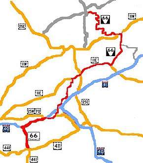
State Route 66 (SR 66) is a state-maintained highway in eastern Tennessee, including a six-lane divided highway segment in Sevier County and a two-lane segment through mountainous terrain to the northeast.
| ||||
|---|---|---|---|---|
 | ||||
| Route information | ||||
| Maintained by TDOT | ||||
| Length | 86.25 mi (138.81 km) | |||
| Major junctions | ||||
| South end | ||||
| North end | ||||
| Location | ||||
| Counties | Sevier, Jefferson, Hamblen, Hawkins, Hancock | |||
| Highway system | ||||
| ||||


Route Description
Sevier County
SR 66 begins as a primary highway in Sevier County in Sevierville at an intersection with US 441/US 411/SR 35/SR 71 (Chapman Highway/Forks of the River Parkway/Main Street) in downtown. The highway goes north as a 6-lane undivided highway (Winfield Dunn Parkway) to leave downtown and cross a bridge over the Little Pigeon River to have an intersection with SR 448 (North Parkway). The highway then becomes divided at the intersection with Allensville Road and continues north through a long major business district and has a concurrency with SR 338 (Douglas Dam Road/Boyds Creek Highway) before crossing a bridge over the French Broad River to leave Sevierville and enter Kodak. It continues past some more businesses before having an intersection with SR 139 (Douglas Dam Road) before passing some more businesses and coming to an interchange with I-40 (Exit 407). Here, SR 66 becomes unsigned as turns east to become concurrent with I-40 while the road continues north as Snyder Road to US 25W/US 70/SR 9.
This entire 6-lane section of SR 66 is a popular route for tourists traveling to the Great Smoky Mountains National Park as it is also part of the Great Smoky Mountains Parkway.
I-40/SR 66 go east as a 6-lane freeway and cross into Jefferson County shortly afterwards.
Jefferson County
I-40/SR 66 go east through farmland and have an interchange with Deep Springs Road (Exit 412) before coming to an interchange with US 25W/US 70/SR 9 (Exit 415). Here, while SR 66 still remains unsigned, it turns secondary and leaves I-40 to go east, concurrent with US 25W/US 70/SR 9, and enter Dandridge. The highway passes through farmland as a 2-lane highway before becoming concurrent with SR 92 as they enter downtown. The highway then passes several businesses before SR 92 splits off in the center of town. After passing through some neighborhoods, SR 66 becomes signed as it splits off from US 25W/US 70/SR 9 to the northeast and leaves Dandridge as Valley Home Road. The highway continues through farmland as it parallels and crosses under I-40, eventually passing just north of the I-40/I-81 interchange and begins paralleling I-81. SR 66 then passes through White Pine, where it has an intersection with SR 341 before crossing into Hamblen County.
Hamblen County
SR 66 continues northeast through farmland and has an intersection with SR 342 before entering Morristown and coming to an intersection with SR 160. Here SR 66 turns east and becomes concurrent with SR 160 as a 4-lane divided highway for about a mile before SR 66 splits off and goes north as an improved 2-lane highway to pass through an industrial area and enter downtown. the highway then turns east to become concurrent with US 11E/SR 34 as a 4-lane undivided highway through a major business district before turning north onto S Fairmount Avenue, leaving US 11E/SR 34 as a 2-lane side street. SR 66 then crosses over the railroad tracks before turning right onto W 1st Street. It then passes by several more businesses before having an intersection with SR 343 in the center of the city, where SR 66 becomes E 1st Street. SR 66 then leaves downtown and continues east as a 4-lane undivided highway (Andrew Johnson Highway) as it passes through neighborhoods before having an interchange with Liberty Hill Road, just before having an interchange with US 25E/US 11E/SR 32/SR 34, where SR 66 again becomes concurrent with US 11E/SR 34 (US 25E/SR 32 Exit 2B). The highway then leaves Morristown as a 4-lane divided highway and passes through Russellville as it narrows to 2-lanes and has an intersection with SR 344. US 11E/SR 34/SR 66 then continue northeast through farmland to pass through Whitesburg and have an extremely short concurrency with SR 113 before crossing into Hawkins County.
Hawkins County
US 11E/SR 34/SR 66 continue northeast through farmland to Bulls Gap, where SR 66 separates from US 11E/SR 34 for the final time as it turns north as a primary highway to leave Bulls Gap and continues through farmland. SR 66 then passes through some hilly terrain before having another intersection with SR 113 and entering Persia. It then becomes concurrent with SR 70 (Trail of the Lonesome Pine) before leaving Persia and continuing north through farmland. They then have an intersection with Old Highway 70 before crossing the Hugh B Day Bridge over Cherokee Lake/Holston River and entering Rogersville. They pass by several businesses before curving to the west and have a partial interchange with West Main Street. They then come to an interchange with US 11W/SR 1, where SR 70 splits off and turns northeast on US 11W/SR 1 while SR 66 turns secondary, becoming extremely narrow and curvy as it leaves Rogersville and enters mountainous terrain. SR 66 then passes through farmland again for a short distance before rentering the mountains to have an intersection with SR 94 before crossing into Hancock County.
Hancock County
SR 66 curves and winds its way through several miles of mountainous terrain before coming to an intersection with SR 31 just south of Sneedville. It then turns right and crosses a bridge over the Clinch River before coming to an end at an intersection with SR 33 just south of downtown.
History
A widening project was recently completed on SR 66 from I-40 to Chapman Highway/Main Street/Forks of the River Parkway (US 441/US 411). It was divided into 3 separate sections, each of which was expanded at different times. It expanded the 4-lane divided highway to a six-lane divided highway. The section closest to Sevierville was expanded first. This section stretched from Boyds Creek Highway (SR 338) to Nichols Street and was completed November 2011. The second section from I-40 to Douglas Dam Road (SR 139) is now under construction was scheduled to be completed on November 30, 2012. This section is now complete. The middle section from Douglas Dam Road to Boyds Creek Highway was to be expanded last when funding became available and was completed in November 2016.[1]
Junction list
| County | Location | mi | km | Destinations | Notes |
|---|---|---|---|---|---|
| Sevier | Sevierville | 0.0 | 0.0 | Southern terminus; SR 66 begins as a primary highway | |
| Bridge over the Little Pigeon River | |||||
| Northern terminus of SR 448 | |||||
| Southern end of concurrency with SR 338 | |||||
| Northern end of concurrency with SR 338 | |||||
| Sevierville–Kodak line | Bridge over the French Broad River | ||||
| Kodak | |||||
| Begin unsigned concurrency with I-40; Road continues northward as Snyder Road; Diverging diamond interchange; I-40 Exit 407 | |||||
| Jefferson | | Deep Springs Road – Douglas Dam | I-40 exit 412 | ||
| | End unsigned concurrency with I-40, Begin unsigned concurrency with US 25W/US 70/SR 9; SR 66 turns secondary; I-40 Exit 415 | ||||
| Dandridge | Begin concurrency with SR 92, from here on the concurrency is signed | ||||
| End concurrency with SR 92 | |||||
| End concurrency with US 25W/US 70/SR 9 | |||||
| White Pine | Access to I-81 via SR 341 East | ||||
| Hamblen | | Eastern terminus of SR 342 | |||
| Morristown | Begin concurrency with SR 160 | ||||
| End concurrency with SR 160 | |||||
| Begin concurrency with US 11E/SR 34 | |||||
| End concurrency with US 11E/SR 34 | |||||
| Liberty Hill Road | Interchange | ||||
| Interchange; Begin concurrency with US 11E/SR 34 | |||||
| Russellville | Southern terminus of SR 344 | ||||
| Whitesburg | Very short 46 ft concurrency with SR 113 | ||||
| Hawkins | Bulls Gap | End concurrency with US 11E/SR 34; SR 66 becomes primary | |||
| Persia | Northern terminus of SR 113 | ||||
| Begin concurrency with SR 70 | |||||
| | Hugh B Day Bridge over Cherokee Lake/Holston River | ||||
| Rogersville | West Main Street – Downtown Rogersville | Interchange; no southbound access | |||
| interchange; End concurrency with SR 70; SR 66 turns secondary | |||||
| | Western terminus of SR 94 | ||||
| Hancock | Sneedville | Northern terminus of SR 31 | |||
| Bridge over the Clinch River | |||||
| 86.25 | 138.81 | Northern terminus; SR 66 ends as a secondary highway | |||
1.000 mi = 1.609 km; 1.000 km = 0.621 mi
| |||||
See also


References
External links
