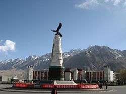
Tashkurgan
Tashkurgan (Uyghur: تاشقورغان بازىرى, Ташқурган ; Sarikoli: [tɔʃqyrʁɔn buzur]; Chinese: 塔什库尔干镇; pinyin: Tǎshíkù'ěrgān Zhèn) is a town in the far north west of China, close to the borders of Tajikistan, Afghanistan and Pakistan. It is the principal town and seat of Tashkurgan Tajik Autonomous County, in the autonomous region of Xinjiang.
Tashkurgan تاشقورغان بازىرى 塔什库尔干镇 | |
|---|---|
| Taxkorgan | |
 | |
 Tashkurgan Location in Xinjiang 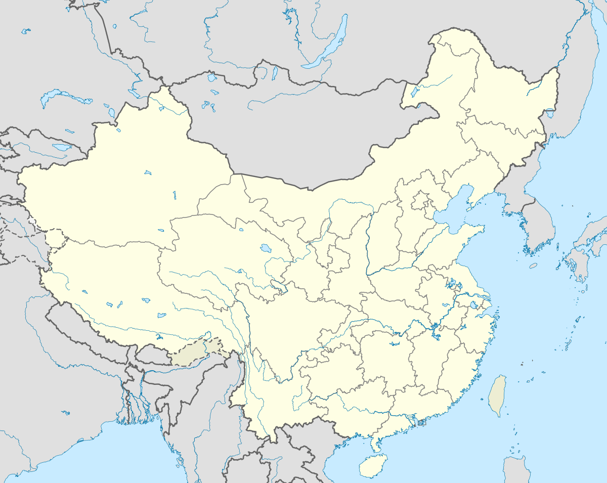 Tashkurgan Tashkurgan (China) | |
| Coordinates: 37°46′22″N 75°13′28″E | |
| Country | |
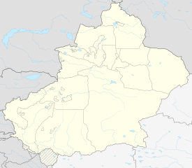
| Region | Xinjiang |
| Prefecture | Kashgar |
| County | Tashkurgan |
| Residential communities | 6 |
| Area | |
| • Total | 4 km2 (2 sq mi) |
| Elevation | 3,094 m (10,151 ft) |
| Population (2010)[2] | |
| • Total | 8,919 |
| • Density | 2,200/km2 (5,800/sq mi) |
| Ethnic groups | |
| • Major ethnic groups | Mountain Tajik (China)[1] |
| Time zone | UTC+8 (China Standard) |
Name
Tashkurgan means "Stone Fortress" or "Stone Tower" in the Turkic languages. The historical Chinese name for the town was a literal translation (Chinese: 石头城, Shítouchéng). The official spelling is Taxkorgan,[3] while Tashkorgan and Tashkurghan appear occasionally in literature. The town's name is written in the Uyghur Arabic alphabet as تاشقۇرغان and in the Uyghur Latin alphabet Tashqurghan baziri. Historically, the town was also called Sarikol (سريكال) or Sariqol (سرقول) or the traditional spelling (ساريق قول).
History
| Chinese Wikisource has original text related to this article: |
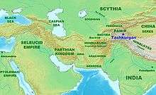
Tashkurgan has a long history as a stop on the Silk Road. Major caravan routes converged here leading to Kashgar in the north, Yecheng to the east, Badakhshan and Wakhan to the west, and Chitral and Hunza to the southwest (modern Khyber Pakhtunkhwa and Gilgit-Baltistan, Pakistan).
About 2000 years ago, during the Han dynasty, Tashkurgan was the main centre of the Kingdom of Puli (Chinese: 蒲犁) mentioned in the Book of Han and the Book of the Later Han. Later it became known as Varshadeh.[4][5] Mentions in the Weilüe of the Kingdom of Manli (滿犁) probably also refer to Tashkurgan.[6]
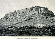
Some scholars believe that a "Stone Tower" mentioned by Ptolemy and by other early accounts of travel on the Silk Road refers to this site. This tower is said to have marked the midway point between Europe and China. Other scholars, however, disagree with this identification, though it remains one of the four most probable sites for the Stone Tower.[7]
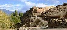
Many centuries later Tashkurgan became the capital of the Sarikol kingdom (色勒库尔), a kingdom of the Pamir Mountains, and later of Qiepantuo (朅盘陀) under the Persian Empire. At the northeast corner of the town is a huge fortress known as the Princess Castle dating from the Yuan dynasty (1279–1368 CE) and the subject of many colourful local legends. A ruined fire temple is near the fortress.
The Buddhist monk Xuanzang passed through Tashkurgan around 649 CE, on his way to Khotan from Badakhshan, as did Song Yun around 500 CE. When Aurel Stein passed through the town in the early twentieth century he was pleased to find that Tashkurgan matched the descriptions left by those travellers: discussing Qiepantuo, Xuanzang recorded (in Samuel Beal's translation), "This country is about 200 li in circuit; the capital rests on a great rocky crag of the mountain, and is backed by the river Śitâ. It is about 20 li in circuit."[8][9] Xuanzang's discussion of Qiepantuo in book twelve of Great Tang Records on the Western Regions recounts a tale which might explain the name of the Princess Castle: A Han Chinese princess on her way to marry a Persian king is placed on a high rock for safety during local unrest. She becomes pregnant from a mysterious stranger, ultimately giving birth to a powerful king and founding the royal line ruling at the time of Xuanzang's visit. Stein records a version of this, current at the time of his visit, in which the princess is the daughter of the Persian king Naushīrvān.[10][11]
Aurel Stein argued that, judging from the topography and remains found around Tashkurgan, the fort and associated settlements had clearly been central to the broader Sarikol area, controlling routes from the Oxus to the oases of southern Turkestan.[12]
Xuanzang describes a substantial Buddhist site with tall towers, leading Stein to speculate as to whether the pilgrimage site dedicated to Shāh Auliya, several hundred yards to the northeast of the town site, and in use at the time of his visit, might have seen continuous but changing local use as a holy site down the centuries.[13][14]
In 1959, Tashkurgan Commune (塔什库尔干公社) was established.[1]
In 1984, Tashkurgan Commune became Tashkurgan Town.[1]
In 2010-11, the residential communities of Bulakegale (布拉克尕勒社区) and Xudong (旭东社区) were added to the town and Kuonabazha (阔纳巴扎社区) and Yingshahai'er (英沙海尔社区) were removed.[15][16] In 2016-7, the residential community Xingfu (幸福社区) was added to the town.[17][18] In 2017-8, the residential community Hongqi (红旗社区) was added to the town.[18][19] In 2018-9, the residential community Shajilin (沙棘林社区) was added to the town.[19][20]
Museum
In Tashkurgan there is a museum that houses a few local artifacts, a photographic display and, in the basement, two mummies – one of a young woman about 18 and another of a baby about three months old who was not hers. They are labelled as dating from the Bronze Age to the Warring States period (475−221 BCE). The mummies were discovered in the nearby Xiabandi Valley on the old caravan route to Yarkand. The valley has now been flooded for a hydro-electric project.
Geography
Tashkurgan is the seat of Tashkurgan Tajik Autonomous County. It is situated at an altitude of 3,090 metres (10,140 ft) on the borders of both Afghanistan and Tajikistan, and close to the borders of Kyrgyzstan and Pakistan. Tashkurgan is a market town for sheep, wool and woollen goods, particularly carpets, and is surrounded by orchards. The majority population in the town are ethnic Mountain Tajiks. The majority of people in the region speak Sarikoli. There is also a village of Wakhi speakers. Mandarin Chinese and Uyghur are also spoken.
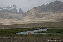
The Tashkurgan River begins just north of the Khunjerab Pass and flows north along the Karakoram Highway to Tashkurgan. Just north of Tashkurgan it turns east and flows through a gorge to the Tarim Basin where it joins the Yarkand River.
Climate
Tashkurgan has a cold desert climate (Köppen BWk), influenced by the high elevation, with long, very cold winters, and warm summers. Monthly daily average temperatures range from −11.9 °C (10.6 °F) in January to 16.4 °C (61.5 °F) in July, while the annual mean is 3.58 °C (38.4 °F). An average of only 68 millimetres (2.68 in) of precipitation falls per year.
| Climate data for Tashkurgan (1971−2000) | |||||||||||||
|---|---|---|---|---|---|---|---|---|---|---|---|---|---|
| Month | Jan | Feb | Mar | Apr | May | Jun | Jul | Aug | Sep | Oct | Nov | Dec | Year |
| Record high °C (°F) | 6.5 (43.7) |
12.2 (54.0) |
18.9 (66.0) |
22.0 (71.6) |
25.1 (77.2) |
31.0 (87.8) |
32.5 (90.5) |
31.4 (88.5) |
27.8 (82.0) |
22.7 (72.9) |
14.3 (57.7) |
10.5 (50.9) |
32.5 (90.5) |
| Average high °C (°F) | −4.2 (24.4) |
−1 (30) |
6.0 (42.8) |
12.8 (55.0) |
16.7 (62.1) |
20.5 (68.9) |
23.7 (74.7) |
23.3 (73.9) |
18.6 (65.5) |
11.6 (52.9) |
4.8 (40.6) |
−1.9 (28.6) |
10.9 (51.6) |
| Daily mean °C (°F) | −11.9 (10.6) |
−8.2 (17.2) |
−0.5 (31.1) |
6.1 (43.0) |
9.8 (49.6) |
13.3 (55.9) |
16.4 (61.5) |
16.0 (60.8) |
11.4 (52.5) |
4.0 (39.2) |
−3.4 (25.9) |
−10.0 (14.0) |
3.6 (38.5) |
| Average low °C (°F) | −18.6 (−1.5) |
−15.3 (4.5) |
−7.3 (18.9) |
−0.8 (30.6) |
3.1 (37.6) |
6.4 (43.5) |
9.4 (48.9) |
8.8 (47.8) |
3.5 (38.3) |
−3.8 (25.2) |
−10.8 (12.6) |
−16.6 (2.1) |
−3.5 (25.7) |
| Record low °C (°F) | −40.1 (−40.2) |
−36.0 (−32.8) |
−25.7 (−14.3) |
−11.5 (11.3) |
−5.6 (21.9) |
−1.0 (30.2) |
2.2 (36.0) |
−0.2 (31.6) |
−5.0 (23.0) |
−12.2 (10.0) |
−23.3 (−9.9) |
−31.5 (−24.7) |
−40.1 (−40.2) |
| Average precipitation mm (inches) | 3.2 (0.13) |
2.6 (0.10) |
2.4 (0.09) |
4.8 (0.19) |
8.0 (0.31) |
15.5 (0.61) |
11.3 (0.44) |
9.6 (0.38) |
6.0 (0.24) |
2.1 (0.08) |
.7 (0.03) |
2.0 (0.08) |
68.2 (2.68) |
| Average precipitation days (≥ 0.1 mm) | 2.1 | 2.4 | 2.2 | 2.5 | 5.1 | 6.8 | 6.2 | 4.6 | 2.9 | 1.7 | .5 | 1.6 | 38.6 |
| Source: Weather China | |||||||||||||
Administrative divisions
As of 2019, the town included six residential communities (Mandarin Chinese pinyin-derived names):[20]
- Kashigale (喀什尕勒社区), Bulakegale (布拉克尕勒社区), Xudong (旭东社区), Xingfu (幸福社区), Hongqi (红旗社区), Shajilin (沙棘林社区)
As of 2009, there were three residential communities:[21]
- Kashigale (喀什尕勒社区), Kuonabazha (阔纳巴扎社区), Yingshahai'er (英沙海尔社区)
Transportation
As the area is remote from populated regions, a hot and high airport is under development and scheduled to complete by 2022, with 3800 meter runway. It will be China's closest airport to Pakistan, Tajikistan, and Afghanistan.
Karakoram Highway
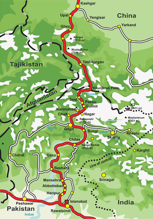
Today Tashkurgan is on the Karakoram Highway which follows the old Silk Road route from China to Pakistan.[22] Accommodation is available and it is a recommended overnight stop for road travellers from China to Pakistan, in order to have the best chance of crossing the snow-prone Khunjerab Pass in daylight. Special registration with the police must be made before entering Tashkurgan, and Chinese citizens must receive written permission from their local police department before entering the region.
Travelling from Xinjiang, it is about 230 kilometres (140 mi) south of Kashgar and is the last town before the border with Pakistan. It is 120 kilometres (75 mi) over the Khunjerab Pass from Sust, which is the Pakistani border town. Passenger road service between Tashkurgan and the Pakistani towns of Sust and Gilgit has existed for many years, and road service between Kashgar and Gilgit (via Tashkurgan and Sust) started in summer 2006. However, the border crossing between China and Pakistan at Khunjerab Pass (the highest border of the world) is open only between May 1 and October 15. During winter, the roads are blocked by snow. [23]
See also
Footnotes
- 1997年塔什库尔干县行政区划. XZQH.org (in Chinese). 18 November 2010. Retrieved 19 April 2020.
塔什库尔干镇 县政府驻地。清光绪年间为蒲犁厅底驿。1950年为一区三乡,1959年成立塔什库尔干公社,1984年改镇。面积4平方千米,人口0.5万,其中塔吉克族占50.1%,辖喀什尕勒、库勒巴扎、英协海尔3个居委会。镇区自西汉以来为历代军政机关驻地,中西政治、经济、文化和商旅交往的门户。314国道从镇内通过。镇北有古代“石头城”城堡遗址。
- 塔什库尔干县历史沿革. XZQH.org (in Chinese). 14 November 2014. Retrieved 19 April 2020.
2000年第五次人口普查,塔什库尔干塔吉克自治县常住总人口30454人,其中:塔什库尔干镇5112人、{...}2010年第六次人口普查,塔什库尔干塔吉克自治县常住总人口37843人,其中:塔什库尔干镇8919人,
- Complete Atlas Of The World (3 ed.). Penguin Random House. 2016. p. 238. ISBN 978-1-4654-4401-1 – via Internet Archive.
Taxkorgan
- Hill (2009), Note 20.2, pp. 394-401.
- Stein, Aurel (1907). Ancient Khotan: Detailed Report of Archaeological Explorations in Chinese Turkestan. Oxford: The Clarendon Press. p. 39.
- Hill, John E. 2004. The Peoples of the West from the Weilüe 魏略 by Yu Huan 魚豢: A Third Century Chinese Account Composed between 239 and 265 CE. Draft annotated English translation... Link
- Dean, Riaz (2015). "The Location of Ptolemy's Stone Tower: the Case for Sulaiman-Too in Osh". The Silk Road. 13.
- Stein, Aurel (1903). Sand-Buried Ruins of Khotan: Personal Narrative of a Journey of Archaeological and Geographical Exploration in Chinese Turkestan. London: T.F. Unwin. p. 72.
- Xuanzang; Samuel Beal (1884). Si-Yu-Ki. Buddhist Records of the Western World. Translated from the Chinese of Hiuen Tsiang (A.D. 629) by S. Beal. London: Trübner. pp. 298–99.
- Xuanzang (1884). Si-Yu-Ki. Buddhist Records of the Western World. Translated from the Chinese of Hiuen Tsiang (A.D. 629) by S. Beal. London: Trübner. pp. 300–301.
- Stein, Aurel (1907). Ancient Khotan: Detailed Report of Archaeological Explorations in Chinese Turkestan. Oxford: The Clarendon Press. pp. 34–35.
- Stein, Aurel (1907). Ancient Khotan: Detailed Report of Archaeological Explorations in Chinese Turkestan. Oxford: Clarendon Press. p. 23.
- Stein, Aurel (1928). Innermost Asia: Detailed Report of Explorations in Central Asia, Kan-su and Eastern Iran, Carried Out and Described under the Orders of H.M. Indian Government. Oxford: Clarendon Press. p. 58.
- Xuanzang (1884). Si-Yu-Ki. Buddhist Records of the Western World. Translated from the Chinese of Hiuen Tsiang (A.D. 629) by S. Beal. London: Trübner. p. 302.
- 2010年统计用区划代码和城乡划分代码:塔什库尔干镇 (in Chinese). National Bureau of Statistics of the People's Republic of China. 2010. Retrieved 20 April 2020.
代码 城乡分类 名称 653131100001 121 喀什尕勒居委会 653131100002 121 阔纳巴扎居委会 653131100003 121 英沙海尔居委会
- 2011年统计用区划代码和城乡划分代码:塔什库尔干镇 (in Chinese). National Bureau of Statistics of the People's Republic of China. 2011. Retrieved 20 April 2020.
代码 城乡分类 名称 653131100001 121 喀什尕勒社区居委会 653131100002 121 布拉克尕勒社区居委会 653131100003 121 旭东社区居委会
- 2016年统计用区划代码和城乡划分代码:塔什库尔干镇 (in Chinese). National Bureau of Statistics of the People's Republic of China. 2016. Retrieved 20 April 2020.
统计用区划代码 城乡分类代码 名称 653131100001 121 喀什尕勒社区居委会 653131100002 121 布拉克尕勒社区居委会 653131100003 121 旭东社区居委会
- 2017年统计用区划代码和城乡划分代码:塔什库尔干镇 (in Chinese). National Bureau of Statistics of the People's Republic of China. 2017. Retrieved 20 April 2020.
统计用区划代码 城乡分类代码 名称 653131100001 121 喀什尕勒社区居委会 653131100002 121 布拉克尕勒社区居委会 653131100003 121 旭东社区居委会 653131100004 121 幸福社区居民委员会
- 2018年统计用区划代码和城乡划分代码:塔什库尔干镇 (in Chinese). National Bureau of Statistics of the People's Republic of China. 2018. Retrieved 20 April 2020.
统计用区划代码 城乡分类代码 名称 653131100001 121 喀什尕勒社区居委会 653131100002 121 布拉克尕勒社区居委会 653131100003 121 旭东社区居委会 653131100004 121 幸福社区居民委员会 653131100005 121 塔什库尔干镇红旗社区居民委员会
- 2019年统计用区划代码和城乡划分代码:塔什库尔干镇 (in Chinese). National Bureau of Statistics of the People's Republic of China. 2019. Retrieved 19 April 2020.
统计用区划代码 城乡分类代码 名称 653131100001 121 喀什尕勒社区居委会 653131100002 121 布拉克尕勒社区居委会 653131100003 121 旭东社区居委会 653131100004 121 幸福社区居民委员会 653131100005 121 塔什库尔干镇红旗社区居民委员会 653131100006 121 沙棘林社区居民委员会
- 2009年统计用区划代码和城乡划分代码:塔什库尔干镇 (in Chinese). National Bureau of Statistics of the People's Republic of China. 2009. Retrieved 19 April 2020.
代码 城乡分类 名称 653131100001 121 喀什尕勒居委会 653131100002 121 阔纳巴扎居委会 653131100003 121 英沙海尔居委会
- "Karakoram Highway". www.dangerousroads.org. Retrieved 12 May 2017.
- "World's biggest building project aims to make China great again". The Guardian. 11 May 2017. Retrieved 12 May 2017.
References
- Curzon, George Nathaniel. 1896. The Pamirs and the Source of the Oxus. Royal Geographical Society, London. Reprint: Elibron Classics Series, Adamant Media Corporation. 2005. ISBN 1-4021-5983-8 (pbk); ISBN 1-4021-3090-2 (hbk).
- Hill, John E. (2009). Through the Jade Gate to Rome: A Study of the Silk Routes during the Later Han Dynasty, First to Second Centuries CE. John E. Hill. BookSurge. ISBN 978-1-4392-2134-1.
- 库尔班, 西仁, 马达 力包仑, and 米尔扎 杜斯买买提. 中国塔吉克史料汇编. Ürümqi: 新疆大学出版社, 2003. ISBN 7-5631-1792-X.
External links
| Wikimedia Commons has media related to Tashkurgan. |
- Check out note 20.2. to the translation of the Hou Hanshu by John Hill. http://depts.washington.edu/silkroad/texts/hhshu/hou_han_shu.html
- For a brief description and some photos.