Tarui Ichirizuka
Tarui Ichirizuka (垂井一里塚) is a historic Japanese distance marker akin to a milestone, consisting of an earthen mounds located in what is now part of the town of Tarui, Gifu Prefecture in the Chubu region of Japan. It was designated a National Historic Site of Japan in 1930.[1]
垂井一里塚 | |
 Tarui Ichirizuka | |
 Tarui Ichirizuka  Tarui Ichirizuka (Japan) | |
| Location | Tarui, Gifu, Japan |
|---|---|
| Region | Chubu region |
| Coordinates | 35°22′14″N 136°30′42″E |
| History | |
| Periods | Edo period |
| Site notes | |
| Ownership | National Historic Site |
| Public access | Yes |
Overview
During the Edo period Tokugawa shogunate established ichirizuka on major roads, enabling calculation both of distance travelled and of the charge for transportation by kago or palanquin.[2] These markers were a pair earthen mounds and denoted the distance in ri (3.927 kilometres (2.440 mi)) to Nihonbashi, the "Bridge of Japan", erected in Edo in 1603.[3]
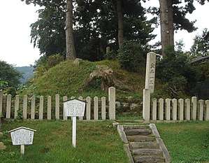
In the case of the Tarui ishirizuka, there is only a single mound, which is located on the southern side of the Nakasendō, one of the major routes between Edo and Kyoto. This marker is 112 ri from Nihonbashi. The mound is also located near the site of the Battle of Sekigahara, and was erected on the location of the field headquarters of Asano Yoshinaga. The mound is in very good preservation, with a height of about 4.7 meters and a diameter of about 20 meters.
References
- "垂井一里塚" [tarui Ichirizuka] (in Japanese). Agency for Cultural Affairs.
- "Tokyo Cultural Properties Database: Nishigahara Ichirizuka". Tokyo Metropolitan Government. Retrieved 3 July 2012.
- Nenzi, Laura (2008). Excursions in Identity: Travel and the Intersection of Place, Gender, and Status in Edo Japan. University of Hawaii Press. pp. 21–22. ISBN 978-0-824-83117-2.
External links
- Gifu prefecture official site (in Japanese)
- Tarui town cultural properties (in Japanese)