Tanjung Bara
Tanjung Bara (TBCT) is a coal loading port in Indonesia.[1] Primarily known for its coal loading terminal (TBCT - Tanjung Bara Coal Terminal), it lies on the southeast coast of East Kalimantan, Borneo.[2]
| Tanjung Bara | |
|---|---|
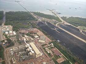 Aerial view of Tanjung Bara | |
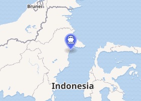
Location of Tanjung Bara in Kalimantan | |
| Location | |
| Country | |
| Location | East Kutai, East Kalimantan |
| Coordinates | 0°35′9.68″N 117°42′13.34″E |
| UN/LOCODE | IDTBA |
| Details | |
| Operated by | Kaltim Prima Coal |
| Owned by | Kaltim Prima Coal |
| Type of harbor | Coal Port |
| Wharfs | 4 |
Location
Tanjung Bara is located on the island of Kalimantan, in the East Kutai Regency.[3] It lies about 20 kilometers north east off the town of Sangatta and Sangatta Coal Mine. The closest city to Tanjung Bara is Bontang.[4]
Port information
The port of Tanjung Bara is often also known as TBCT (Tanjung Bara Coal Terminal). The terminal started its operations in 1991 and has 4 concrete wharves with a length of 350 metres. A a depth alongside of 17.25 m at the Lowest astronomical tide (LAT) allows it to accommodate cape sized vessels. Tanjung Bara itself has a fair tidal range f 4.4 to 2.8 metres. The channel leading to the port has a higher draft allowed of 25 m. While the stockpile on the jetty can store up to 1.25 million tonnes of coal, each of the quadrant type loaders is capable of loading at a rate of 4,200 tonnes per hour, with a trajectory of 7 metres. The port works around the clock and accepts bulk carriers of a length of 310 m and a breadth of 50m. The maximum size of ships that have berthed at TBCT is 210,000 DWT, usually starboard side alongside. 2 tugs of 40 tonnes bollard pull are available and pilots usually board ships 7 miles away from the berth by boat.[5]
The closest town to the port is the town of Sangatta; the capital of East Kutai Regency, which lies north of Bontang and Samarinda.[6]
The port is owned and operated by Kaltim Prima Coal, a joint venture of BP and Rio Tinto.[7]
Taboneo (Banjarmasin) and Tanjung Bara (TBCT) are among the largest coal loading ports of Indonesia.[8]
References
- "Location of Tanjung Bara". www.marinetraffic.com. Marine traffic. Retrieved 22 September 2017.
- "Tg Bara - port information". www.port-directory.com. World Port Directory. Retrieved 22 September 2017.
- "Tamnjung Bara - Port information". www.vesselfinder.com. Vessel finder - Ports and Terminals. Retrieved 22 September 2017.
- "Port of Tanjung Bara". www.marinetraffic.com. Marine traffic. Retrieved 22 September 2017.
- Tanjung Bara - Port Information (PDF) (1 ed.). Djakarta: Macor Ship. Retrieved 22 September 2017.
- Guide to port entry (2017 ed.). London: World Ports Inc. / IHS. 5 January 2017.
- "TBCT - Port information". www.sourcewatch.org. Source watch. Retrieved 22 September 2017.
- Admiralty sailing directions - Indonesia (10th ed.). Taunton: UK Hydrographic office. 15 July 2015.