Stilaro
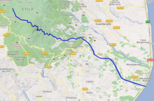
The Stilaro (in antiquity the Elleporus or possibly Elleporos;[1] in Calabrian dialect Stilaru) is an Italian river, which runs through Bivongi, Pazzano and Stilo in the Province of Reggio Calabria, Calabria and, along with the river, gives its name to the Vallata dello Stilaro Allaro, the valley through which it flows. It is 59.17 km long.
| Stilaro | |
|---|---|
.jpg) | |
 | |
| Location | |
| Country | Italy |
| Physical characteristics | |
| Source | |
| • elevation | 1,400 m (4,600 ft) |
| Mouth | Ionian Sea |
• coordinates | 38°25′34″N 16°34′16″E |
• elevation | 0 m (0 ft) |
| Length | 59.17 km (36.77 mi) |
| Basin size | 95.04 km2 (36.70 sq mi) |

Along the river there are remains of iron works, which arose with the industrialization of the area, mills and two hydroelectric plants.
In 389 BC, the Battle of the Elleporus was alongside the river.
Tributaries
- Cellia
- Melodare
- Pardalà
- Torrente Ruggero
- Torrente Folea
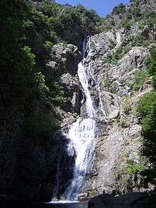
Cascata del Marmarico
A significant feature of the river is the Cascata del Marmarico which, at 114 metres, is the tallest waterfall both in the region of Calabria and in the Southern Apennines. Its name, Marmarico means “slow” and “heavy”, perhaps deriving from the fact that the water seems to hang in motionless threads.
| Wikimedia Commons has media related to Stilaro. |
References
- Richard J.A. Talbert, ed. (2000). Barrington Atlas of the Greek and Roman World: Map-By-Map Directory. I. Princeton, NJ and Oxford, UK: Princeton University Press. p. 703. ISBN 0691049459.