South Carolina Highway 908
South Carolina Highway 908 (SC 908) is a 7.6-mile-long (12.2 km) state highway in the U.S. state of South Carolina. The highway connects rural areas of Marion County with Brittons Neck.
| ||||
|---|---|---|---|---|
| ||||
| Route information | ||||
| Maintained by SCDOT | ||||
| Length | 7.61 mi[1] (12.25 km) | |||
| Major junctions | ||||
| South end | ||||
| North end | ||||
| Location | ||||
| Counties | Marion | |||
| Highway system | ||||
| ||||

Route description
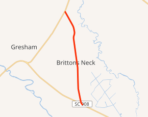
SC 908 begins at a skewed intersection with U.S. Route 378 (US 378) northeast of Johnsonville, Marion County, where the roadway continues south as a dirt road to the Woodbury Wildlife Management Area. It travels to the north-northwest and curves to a nearly due north direction. Just before it travels through Brittons Neck, it curves to the north-northwest and crosses Alligator Run. In the community, it passes a U.S. Post Office. Just after crossing Marsh Creek, it meets its northern terminus, an intersection with SC 41 at a point south of Centenary.[2]
Major intersections
The entire route is in Marion County.
| Location | mi[1] | km | Destinations | Notes | |
|---|---|---|---|---|---|
| | 0.00 | 0.00 | |||
| | 7.61 | 12.25 | |||
| 1.000 mi = 1.609 km; 1.000 km = 0.621 mi | |||||
See also


References
- "Statewide Highways (shapefile)" (zip). South Carolina Department of Transportation. September 29, 2017. Retrieved December 8, 2017.
- Google (May 18, 2016). "South Carolina Highway 908" (Map). Google Maps. Google. Retrieved May 18, 2016.
External links

- SC 908 South Carolina Hwy Index