South Carolina Highway 57
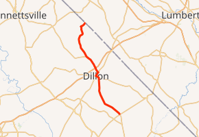
South Carolina Highway 57 (SC 57) is a 25.9-mile-long (41.7 km) state highway in the northeastern part of the U.S. state of South Carolina. The highway travels in a southeast-northwest orientation from the unincorporated community of Fork northwest through Dillon to Little Rock and then curves northeasterly to the North Carolina state line, north of Little Rock, all completely within Dillon County.
| ||||
|---|---|---|---|---|
| ||||
| Route information | ||||
| Maintained by SCDOT | ||||
| Length | 25.9 mi[1] (41.7 km) | |||
| Major junctions | ||||
| South end | ||||
| North end | Fairley Road at the North Carolina state line near Little Rock | |||
| Location | ||||
| Counties | Dillon | |||
| Highway system | ||||
| ||||

Route description
SC 57 begins at an intersection with SC 41 and SC 41 Alternate in Fork. The route heads northeast through the town of Floydale until it enters Dillon. In town, the highway intersects SC 9, and the two routes form a concurrency to the northwest. They run along East Main Street until they meet U.S. Route 301 (US 301), US 501, and SC 34. SC 9/SC 57 turn right onto US 301/US 501 (North 2nd Avenue) slightly to the northeast. At Julia Lane, they split off from the concurrency to the northwest. They have an interchange with Interstate 95 (I-95) just before leaving the city. At the northern part of Little Rock, SC 57 departs the concurrency curving to the northeast until it meets its northern terminus, the North Carolina state line north of Little Rock. Here, the roadway continues as Fairley Road northeast to Raemon.[1]
SC 57 is not part of the National Highway System, a system of roadways important to the nation's economy, defense, and mobility.[2]
History
Major intersections
The entire route is in Dillon County.
| Location | mi[1] | km | Destinations | Notes | |
|---|---|---|---|---|---|
| Fork | 0.0 | 0.0 | |||
| Dillon | 10.6 | 17.1 | Southern end of SC 9 concurrency | ||
| 11.3 | 18.2 | Southern end of US 301/US 501 concurrency; eastern terminus of SC 34 | |||
| 12.3 | 19.8 | Northern end of US 301/US 501 concurrency | |||
| 13.4 | 21.6 | Exit 193 (I-95) | |||
| Little Rock | 16.7 | 26.9 | Northern end of SC 9 concurrency | ||
| | 25.9 | 41.7 | Fairley Road | Continuation beyond North Carolina state line | |
1.000 mi = 1.609 km; 1.000 km = 0.621 mi
| |||||
See also


References
- Google (February 3, 2013). "Route of SC 57" (Map). Google Maps. Google. Retrieved February 3, 2013.
- "National Highway System: South Carolina" (PDF). United States Department of Transportation. October 1, 2012. Retrieved July 1, 2013.
External links

- SC 57 South Carolina Hwy Index