South Carolina Highway 4
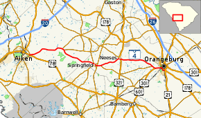
South Carolina Highway 4 (SC 4) is a 54.2-mile-long (87.2 km) state highway in the southern part of the U.S. state of South Carolina. The highway connects Aiken and Orangeburg, via Springfield and Neeses.
| ||||
|---|---|---|---|---|
 | ||||
| Route information | ||||
| Maintained by SCDOT | ||||
| Length | 54.43 mi[1] (87.60 km) | |||
| Major junctions | ||||
| West end | ||||
| East end | ||||
| Location | ||||
| Counties | Aiken, Orangeburg | |||
| Highway system | ||||
| ||||

Route description
SC 4 begins at an intersection with U.S. Route 78 (US 78; Charleston Highway) southeast of Aiken. The route travels to the east-northeast and intersects US 78 Truck/SC 118/SC 302 (Rudy Mason Parkway). SC 4 and SC 302 form an approximately 12-mile-long (19 km) concurrency. They curve to the northeast and cross Shaw Creek. They curve to the east-southeast and curve back to the northeast before crossing the South Fork Edisto River and Cedar Creek. The two highways curve to the southeast and split north of Aiken State Park. SC 4 crosses over Burcalo Creek and then intersects SC 394 (Salley Road). It curves to the east-southeast and passes north of the Aiken Gopher Tortoise Heritage Preserve/Wildlife Management Area. It curves to the east-northeast and enters Orangeburg County.[2]
SC 4 curves to the east-southeast and crosses Dean Swamp Creek. It curves to the southeast and enters Springfield. Right after entering the city limits, it curves to the south-southeast. It turns left onto SC 39 (Springfield Road). The two highways travel concurrently to the northeast for one block. One more block after that, it begins a concurrency with SC 3 Business. (SC 3 Bus.) They split three blocks later, with SC 4 heading south-southeast. It curves to the east-southeast and leaves Springfield. The highway immediately intersects SC 3 (Capital Way). It heads to the east and crosses Goodland Creek. It begins curving to the northeast and intersects SC 332 (Norway Road). The highway passes Rocky Swamp Cemetery and crosses Rocky Swamp Creek. It curves to the east-southeast and crosses Bolen Mill Creek before heading back to the northeast. It begins to curve to the east-southeast and enters Neeses. In Neeses, the route intersects US 321 (Savannah Highway). It heads east and passes Hickory Hill Cemetery, Pine Hill Cemetery, and Double Branch Cemetery before curving to the east-southeast. The highway crosses over Great Branch and curves to the southeast. Then, it crosses over Fourmile Creek and intersects the eastern terminus of SC 400 (Norway Road). SC 4 enters Edisto and curves to the east-southeast. It intersects US 301/US 601. The three highway travel concurrently to the east-northeast. They cross over the North Fork Edisto River, where they leave Edisto and enter Orangeburg. Immediately, they intersect the southern terminus of SC 33 (Russell Street). The concurrency intersects US 601 Truck. Here, SC 4 travels to the south-southeast, concurrent with US 601 Truck. They cross over some railroad tracks and pass by Southern Methodist College. The road curves around to the east-northeast and an intersection with US 21 and US 21 Bus. ends the state highway.[2]
History
Major intersections
| County | Location | mi[2] | km | Destinations | Notes |
|---|---|---|---|---|---|
| Aiken | | 0.00– 0.07 | 0.00– 0.11 | ||
| | 0.18 | 0.29 | Western end of SC 302 concurrency | ||
| | 12.83 | 20.65 | Eastern end of SC 302 concurrency | ||
| | 13.92 | 22.40 | |||
| Orangeburg | Springfield | 26.29 | 42.31 | Western end of SC 39 concurrency | |
| 26.38 | 42.45 | Eastern end of SC 39 concurrency | |||
| 26.41 | 42.50 | Western end of SC 3 Bus. concurrency | |||
| 26.69 | 42.95 | Eastern end of SC 3 Bus. concurrency | |||
| | 27.50 | 44.26 | |||
| | 29.00 | 46.67 | Western terminus of SC 332 | ||
| Neeses | 36.64 | 58.97 | |||
| | 49.23 | 79.23 | Eastern terminus of SC 400 | ||
| Edisto | 50.50 | 81.27 | Western end of US 301 / US 601 concurrency | ||
| Orangeburg | 52.35 | 84.25 | Southern terminus of SC 33 | ||
| 52.52 | 84.52 | Eastern end of US 301/US 601 concurrency; western end of US 601 Truck concurrency | |||
| | 54.43 | 87.60 | Southern terminus of US 21 Bus.; eastern end of US 21 Truck concurrency | ||
1.000 mi = 1.609 km; 1.000 km = 0.621 mi
| |||||
See also


References
- "Statewide Highways (shapefile)" (zip). South Carolina Department of Transportation. September 29, 2017. Retrieved December 8, 2017.
- Google (February 2, 2013). "Route of SC 4" (Map). Google Maps. Google. Retrieved February 2, 2013.
External links

- SC 4 - South Carolina Hwy Index