South Carolina Highway 124
South Carolina Highway 124 (SC 124) is a 5.63-mile-long (9.06 km) state highway in the U.S. state of South Carolina. The highway connects Parker and Greenville.
| ||||
|---|---|---|---|---|
 | ||||
| Route information | ||||
| Maintained by SCDOT | ||||
| Length | 5.63 mi[1] (9.06 km) | |||
| Major junctions | ||||
| West end | ||||
| ||||
| East end | ||||
| Location | ||||
| Counties | Pickens, Greenville | |||
| Highway system | ||||
| ||||

Route description
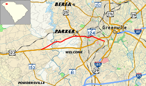
SC 124 begins at an intersection with U.S. Route 123 (US 123; Calhoun Memorial Highway) southwest of Parker, within Pickens County. It travels to the northeast and immediately crosses Georges Creek. It curves to the east-northeast and crosses the Saluda River, where it enters Greenville County and Parker. It begins paralleling some railroad tracks just before intersecting SC 253 at its southern terminus and an interchange with U.S. Route 25 (US 25; White Horse Road). It passes Graceland Cemetery West. On the northeastern corner of the cemetery, the highway curves to the east-southeast and leaves the railroad tracks. It crosses some railroad tracks and curves to the east-northeast. It enters Greenville and begins to curve to the southeast. It has a second intersection with US 123 (Easley Bridge Road/Academy Street). Just northwest of the Greenville Senior High Academy of Law, Finance, and Business, the highway meets its eastern terminus, an intersection with Anderson Street (where SC 81 also ends) and Vardry Street.[2]
Major intersections
| County | Location | mi[1] | km | Destinations | Notes |
|---|---|---|---|---|---|
| Pickens | | 0.00– 0.06 | 0.00– 0.097 | ||
| Greenville | Parker | 2.86 | 4.60 | Southern terminus of SC 253 | |
| 3.38– 3.57 | 5.44– 5.75 | Interchange | |||
| Greenville | 5.13 | 8.26 | |||
| 5.63 | 9.06 | Northern terminus of SC 81 | |||
| 1.000 mi = 1.609 km; 1.000 km = 0.621 mi | |||||
See also


References
- "Statewide Highways (shapefile)" (zip). South Carolina Department of Transportation. September 29, 2017. Retrieved December 8, 2017.
- Google (May 19, 2016). "South Carolina Highway 124" (Map). Google Maps. Google. Retrieved May 19, 2016.
External links

- SC 124 South Carolina Hwy Index