Soco Gap
Soco Gap (el. 4,340 ft (1,320 m)) is a mountain pass between the Plott Balsam Range, to its south, and the Balsam Mountains, to its north. Also known as Ahalunun'yi (ᎠᎭᎷᏄn'Ᏹ), meaning "Ambush Place" or Uni'halu'na (ᎤᏂ'ᎭᎷ'Ꮎ), meaning "where they ambushed;" named after the occasion, probably in the mid 1700s, when the Cherokees ambushed a party of invading Shawnees, all of which were killed except for one, who was sent back (without his ears) to tell his people of the Cherokee victory.[3]
| Soco Gap | |
|---|---|
| ᎠᎭᎷᏄn'Ᏹ Ahalunun'yi, meaning "Ambush Place" | |
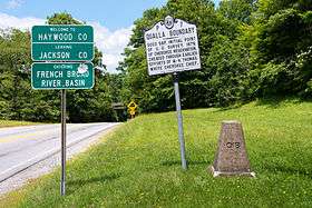 Various boundaries marked at Soco Gap | |
| Elevation | 4,340 ft (1,323 m)[1][2] |
| Traversed by | |
| Location | |
| Range | Balsam Mountains |
| Coordinates | 35°29′43″N 83°09′23″W |
| Topo map | USGS Sylva North |
 | |
The gap is the eastern point of the Qualla Boundary, which marks the territory held as a land trust for the federally recognized Eastern Band of Cherokee Indians. The gap also separates Haywood and Jackson counties and separates the river basins to the [[French Broad River[Pigeon River] and Little Tennessee.
U.S. Route 19 (Soco Road) traverses through the gap, which connects Cherokee and Maggie Valley. The Blue Ridge Parkway also passes through the gap, providing scenic views along the adjacent ridge lines.
References
- General Highway Map, Jackson County, North Carolina (PDF) (Map). North Carolina Department of Transportation. 2014. Retrieved July 18, 2014.
- "Soco Gap". Geographic Names Information System. United States Geological Survey. Retrieved July 18, 2014.
- Rozema, Vicki (2007). Footsteps of the Cherokees (Second ed.). John F. Blair. ISBN 978-0-89587-346-0.
External links
