Skjervøya
Skjervøya (Norwegian) or Skiervá (Northern Sami) is an island in Skjervøy Municipality in Troms og Finnmark county, Norway. The 11.7-square-kilometre (4.5 sq mi) island lies to the east of the island of Kågen and south of the island of Laukøya. The Kvænangen fjord lies to the east of the island. The village of Skjervøy is the main population centre on the island (and it is the administrative centre of the whole municipality). Fishing is one of the main industries on the island. Skjervøya is connected to the mainland by a bridge and then a tunnel. The Skjervøy Bridge connects the island to Kågen island to the west. The undersea Maursund Tunnel the connects Kågen to the mainland.[1]
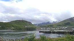 View of the harbor on Skjervøya | |
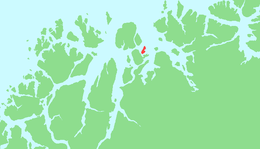 | |
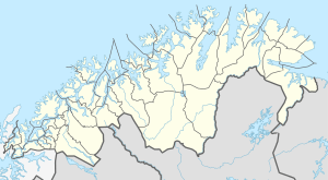 Skjervøya Location of the island  Skjervøya Skjervøya (Norway) | |
| Geography | |
|---|---|
| Location | Troms og Finnmark, Norway |
| Coordinates | 70.0234°N 20.9546°E |
| Area | 11.73 km2 (4.53 sq mi) |
| Length | 7 km (4.3 mi) |
| Width | 2.5 km (1.55 mi) |
| Highest elevation | 345 m (1,132 ft) |
| Highest point | Skattørfjellet |
| Administration | |
Norway | |
| County | Troms og Finnmark |
| Municipality | Skjervøy Municipality |
This article is issued from Wikipedia. The text is licensed under Creative Commons - Attribution - Sharealike. Additional terms may apply for the media files.