Skardu District
Skardu District (Urdu: ضلع سکردو) is part of Baltistan and currently constitutes one of the ten districts of the Gilgit–Baltistan territory of Pakistan.[1] It is bounded on the southeast by Kargil district in Ladakh, on the east by Kharmang District, on the northeast by Ghanche district, on the south by Baramulla and Kargil District, on the west by district Astore and on the north by Shigar District.
Skardu District سکردو | |
|---|---|
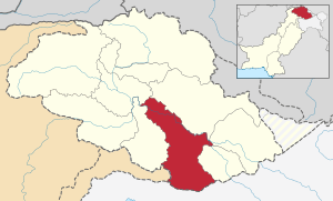 Map of Gilgit–Baltistan with Skardu highlighted in red. | |
| Country | |
| Division | Baltistan |
| Established | July 1, 1970 |
| Capital | Skardu |
| Area | |
| • Total | 15,000 km2 (6,000 sq mi) |
| Population | |
| • Total | 214,848 |
| Time zone | UTC+5 (PKT) |
| Number of Tehsils | 4 |


Skardu town is the capital of the district and of Skardu District.

Mountain peaks and glaciers
The highest peak in Skardu District is K2 (8,611 m) which is the highest peak in Pakistan and the second highest peak on earth. The Baltoro Muztagh (the subrange of Karakoram that includes the mighty peaks of K2 (8,611 m), Broad Peak (8,047 m), Gasherbrum (8,000+ m) and Masherbrum (7,821 m) lie in the Skardu District. Askole is the last settlement in the district for all treks to Concordia (the confluence of Baltoro Glacier and Godwin-Austen Glacier). The Biafo Glacier and a major part of Hispar Glacier are also included in the Skardu District.

Education
According to the Alif Ailaan Pakistan District Education Rankings 2015, Skardu is ranked 14 out of 148 districts in terms of education. For facilities and infrastructure, the district is ranked 89 out of 148.[2]
Deosai National Park
Deosai is one of the highest plains in the world. The district shares the territorial limits of Deosai National Park with Astore which has major portion, (second highest plains after Tibet). The Indus River enters the Gilgit–Baltistan territory from Ladakh.
Major towns
Major towns of Skardu District include: Skardu, Roundu Valley, Parkutta, Sermik, Hussainabad Skardu, and Mehdiabad, Sadpara.
Mountain passes
Hispar Pass and Gondoghoro Pass are also in the Skardu District.
Demography
Skardu is predominantly Shia, here 98% people are Shia, 2% are Noorbakshia Islam and 2% are Sunni.[3]
Most of the people are very simple and they don't want to take complexity in life and they often use old living life style.
Lakes
Some of the lakes in the district are:
- Snow Lake,
- Satpara Lake,
- Sheosar Lake,
- Kachura Lake,
- Shangrila Lake.
See also
References
- Hussain, Zakir (2018). "Geo-Strategic Significance of Gilgit Baltistan: Political, Economic and Security Interests of Pakistan, India and China (1947-2013)". University of the Punjab , Lahore.
- "Individual district profile link, 2015". Alif Ailaan. Retrieved 2015-05-07.
- "Sectarian Conflict in Gilgit-Baltistan". PILDAT. 1 May 2011.
External links
| Wikimedia Commons has media related to Skardu District. |
| Passes | |
|---|---|
| Valleys |
|
| Cities and towns |
|
| Rivers, glaciers and lakes | |
| Architecture | |
| See also | |