Skálafjørður
Skálafjørður(Danish: Skålefjord), earlier known as Kongshavn, is a fjord (ford) in Eysturoy.
Geography
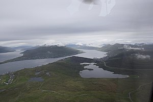
The Skálafjørður is the largest fjord in the Faroe Islands. It measures 14.5 kilometres (9.0 mi) (equidistant line) from in between Raktangi (near Strendur) and Toftir to the village of Skálafjørður.[1] The deepest points are two different spots at circa −70 metres (−230 ft) depth near the villages of Runavík and Søldarfjørður respectively. The entrance of the fjord forms a shallow glacial threshold, at −25 metres (−82 ft) in between Strendur and Saltnes. This threshold limits water circulation in and out of the fjord, compounding oxygen inflow and biological activity.[2] There are national highways on either side of the fjord. The Eysturoyartunnilin, of which the roundabout is situated directly under the threshold (at −72.6 metres (−238 ft)[3]), offers a road connection between Runavík and Strendur, as well as to Tórshavn from 2021.
Villages
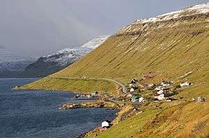
On the eastern bank are the villages, from north to south: Undir Gøtueiði, Skipanes, Søldarfjørður, Lambareiði, Glyvrar, Saltangará, Runavík, Saltnes and Toftir. The last five villages and Nes form one continuous built-up area. On the western bank are Skálafjørður (village), Skáli, Innan Glyvur and Strendur. The fjord is bordered by three municipalities: Runavíkar (to which also Skáli belongs), Eysturkommuna and Sjóvar kommuna.
The village of Skálafjørður was also known as Skálabotnur until 2019.[4] Its beach is the sole officially recognised grind bay.[5]
References