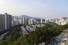
Sha Tin Wai
Sha Tin Wai (Chinese: 沙田圍) is an area in Sha Tin District, New Territories, Hong Kong, named after Sha Tin Wai village (沙田圍村).
Name
The name of the Sha Tin area allegedly comes from the fact that British colonial officials mistook the name of Sha Tin Wai village as the name of the area.
History
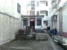
The village was established by the Tse (謝), Cheng (鄭) and Lam (林) clans from Pok Law (Boluo County) in the mid-17th century. Each of the clans has their own ancestral hall.[1] One of the branch of Tse relocated to nearby Yuen Chau Kok to establish their own village.[2]
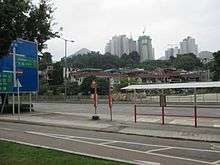
The village was originally built on the Sha Tin Sea waterfront. As a consequence of successive land reclamation of the former estuary that started in 1905, it is now separated from the Shing Mun River by Sha Kok Estate. The Estate was built in Sha Tin New Town-era. Houses of the traditional villages were then built in front of the initial row of houses, and as a consequence, half of today's Sha Tin Wai is built on reclaimed land.[3]
Sha Tin Wai village, its surrounding area, as well as area around Sha Tin station in the opposite shore of Sha Tin Sea, were studied by HKU student in 1963 as a possible site of building Hong Kong's satellite town.[4] Those area were indeed selected by the government to become part of Sha Tin New Town project, which included land reclamation of Sha Tin Sea. The modern day Shing Mun River was the residual of the Sha Tin Sea.
See also
References
- East Rail Extensions - Tai Wai to Ma On Shan. Environmental Impact Assessment Report. Archaeological and Cultural Resources, p 9.8, 1999
- Faure, David (1986). The structure of Chinese Rural Society: Lineage and Village in the Eastern New Territories, Hong Kong. East Asian Historical Monographs. Hong Kong: Oxford University Press. ISBN 0-19-583970-6.
- Ip, Hing-fong (1995). An historical geography of the walled villages of Hong Kong (Postgraduate Thesis, Master of Philosophy). University of Hong Kong. p. 77.
- "沙田圍有可能闢成衛星城市". Wah Kiu Yat Po (in Chinese). Hong Kong. 8 July 1963. p. 5.