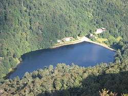
Schiessrothried
Schiessrothried is a small lake in the Alsatian side of the Vosges, of glacial origin. Its waters join the Fecht by a small left tributary, the Wormsabachrunz . At the foot of the Hohneck, it was originally a bog overdeepened and really became a lake by building a small dam very discreet, making many believe that it is of natural origin.
| Schiessrothried | |
|---|---|
 | |
| Location | Haut-Rhin |
| Coordinates | 48.029722°N 7.025278°E |
| Primary outflows | Wormsabachrunz |
| Basin countries | France |
| Surface area | 5.6 ha (14 acres) |
| Max. depth | 11 m (36 ft) |
| Surface elevation | 926 m (3,038 ft) |
The purpose of the dam was to regulate the flow of water to the textile mills and sawmills in the Munster valley, most of which were supplied with electricity independently.
The lake is surrounded by many hiking trails marked out by the Club Vosgien .
At an elevation of 926 m, its surface area is 0.056 km².
References
- Lac du Schiessrothried at elsass-netz.de (German)
- Rainer D. Kröll: Elsass und Vogesen. Bruckmann, 2019, ISBN 9783734315350, pp. 183 (German)
This article is issued from Wikipedia. The text is licensed under Creative Commons - Attribution - Sharealike. Additional terms may apply for the media files.