San Lorenzo barrio-pueblo
San Lorenzo barrio-pueblo is a barrio and the administrative center (seat) of San Lorenzo, a municipality of Puerto Rico. Its population in 2010 was 2,045.[1][4][5][6]
San Lorenzo barrio-pueblo Barrio Pueblo San Lorenzo | |
|---|---|
Municipality Seat[1] | |
 The San Lorenzo City Hall | |
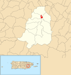 Location of San Lorenzo barrio-pueblo within the municipality of San Lorenzo shown in red | |
 San Lorenzo barrio-pueblo Location of Puerto Rico | |
| Coordinates: 18°11′28″N 65°57′47″W[2] | |
| Commonwealth | |
| Municipality | |
| Area | |
| • Total | 0.22 sq mi (0.6 km2) |
| • Land | 0.22 sq mi (0.6 km2) |
| • Water | 0 sq mi (0 km2) |
| Elevation | 256 ft (78 m) |
| Population (2010) | |
| • Total | 2,045 |
| • Density | 9,738.1/sq mi (3,759.9/km2) |
| Source: 2010 Census | |
| Time zone | UTC−4 (AST) |
As was customary in Spain, in Puerto Rico, the municipality has a barrio called pueblo which contains a central plaza, the municipal buildings (city hall), and a Catholic church. Fiestas patronales (patron saint festivals) are held in the central plaza every year.[7][8]
History
The United States took control of Puerto Rico from Spain in the aftermath of the Spanish-American War under the terms of the Treaty of Paris of 1898. In 1899, the United States conducted its first census of Puerto Rico finding that the population of San Lorenzo Pueblo was 2,084.[9]
The central plaza history
The central plaza, or square, is a place for official and unofficial recreational events and a place where people can gather and socialize from dusk to dawn. The Laws of the Indies, Spanish law, which regulated life in Puerto Rico in the early 19th century, stated the plaza's purpose was for "the parties" (celebrations, festivities) (Spanish: a propósito para las fiestas), and that the square should be proportionally large enough for the number of neighbors (Spanish: grandeza proporcionada al número de vecinos). These Spanish regulations also stated that the streets nearby should be comfortable portals for passersby, protecting them from the elements: sun and rain.[7]
Sectors
Barrios (which are like minor civil divisions)[6] in turn are further subdivided into smaller local populated place areas/units called sectores (sectors in English). The types of sectores may vary, from normally sector to urbanización to reparto to barriada to residencial, among others.[10][11][12]
The following sectors are in San Lorenzo barrio-pueblo:[13][14]
Calle Celso Barbosa, Calle Colón, Calle Condado, Calle Delicias, Calle Dr. Veve Calzada, Calle El Edén, Calle Emilio Buitrago, Calle Federico Sellés, Calle José de Diego, Calle Julia Vázquez, Calle Méndez Álvarez, Calle Muñoz Rivera, Calle Nueva, Calle Policarpio Santana, Calle Ramón Alcalá, Calle Sánchez López, Calle Santiago Iglesias Pantín, Calle Soto, Calle Tomás Delgado, Calle Tous Soto, Calle Valeriano Muñoz, España, Residencial Hato Grande, Reparto Medina, Sector Aril, Sector Asia, Urbanización Las Mercedes, Urbanización Massó, Urbanización San Miguel, and Urbanización y Extensión Jardines de San Lorenzo.
References
- Puerto Rico:2010:population and housing unit counts.pdf (PDF). U.S. Dept. of Commerce, Economics and Statistics Administration, U.S. Census Bureau. 2010.
- "US Gazetteer 2019". US Census. US Government.
- U.S. Geological Survey Geographic Names Information System: San Lorenzo barrio-pueblo
- Picó, Rafael; Buitrago de Santiago, Zayda; Berrios, Hector H. Nueva geografía de Puerto Rico: física, económica, y social, por Rafael Picó. Con la colaboración de Zayda Buitrago de Santiago y Héctor H. Berrios. San Juan Editorial Universitaria, Universidad de Puerto Rico,1969.
- Gwillim Law (20 May 2015). Administrative Subdivisions of Countries: A Comprehensive World Reference, 1900 through 1998. McFarland. p. 300. ISBN 978-1-4766-0447-3. Retrieved 25 December 2018.
- "US Census Barrio-Pueblo definition". factfinder.com. US Census. Archived from the original on 13 May 2017. Retrieved 5 January 2019.
- Santullano, Luis A. (10 March 2019). Mirada al Caribe. 54. Colegio de Mexico. pp. 75–78. doi:10.2307/j.ctvbcd2vs.12. JSTOR j.ctvbcd2vs.12.
- Pariser, Harry S. (2003). Explore Puerto Rico, Fifth Edition. San Francisco: Manatee Press. pp. 52–55. Retrieved 10 February 2019.
- Joseph Prentiss Sanger; Henry Gannett; Walter Francis Willcox (1900). Informe sobre el censo de Puerto Rico, 1899, United States. War Dept. Porto Rico Census Office (in Spanish). Imprenta del gobierno. p. 163.
- "Agencia: Oficina del Coordinador General para el Financiamiento Socioeconómico y la Autogestión (Proposed 2016 Budget)". Puerto Rico Budgets (in Spanish). Retrieved 28 June 2019.
- Rivera Quintero, Marcia (2014), El vuelo de la esperanza: Proyecto de las Comunidades Especiales Puerto Rico, 1997-2004 (first ed.), San Juan, Puerto Rico Fundación Sila M. Calderón, ISBN 978-0-9820806-1-0
- "Leyes del 2001". Lex Juris Puerto Rico (in Spanish). Retrieved 24 June 2020.
- "PRECINTO ELECTORAL SAN LORENZO 086" (PDF). Comisión Estatal de Elecciones (in Spanish). PR Government. 28 May 2019. Retrieved 19 July 2020.
- "PRECINTO ELECTORAL SAN LORENZO 087" (PDF). Comisión Estatal de Elecciones (in Spanish). PR Government. 30 January 2019. Retrieved 19 July 2020.