San Germán Historic District
The San Germán Historic District is a 36-acre (15 ha) historic district located in the western section of the town of San Germán, Puerto Rico. The district was added to the National Register of Historic Places in 1994. The district contains more than 100 significant buildings, including the Church San Germán de Auxerre and the Convento de Porta Coeli.
San Germán Historic District | |
 Plaza Santo Domingo | |
 | |
| Location | San Germán, Puerto Rico |
|---|---|
| Coordinates | 18°04′55″N 67°02′38″W |
| Area | 36 acres (15 ha) |
| Architect | Multiple |
| Architectural style | Colonial, Other |
| NRHP reference No. | 94000084[1] |
| Added to NRHP | February 16, 1994 |
History
Spanish colonists established La Villa de San Germán de Auxerre, also known as Nueva Salamanca, in the early years of the 16th century. The town of San Germán grew out of the settlement formally established in 1573, and it is this original urban core, transformed by rapid growth from the 1830s to the 1940s, that comprises the San Germán Historic District.[2]
The district includes numerous homes, among these the noted Victorian-style Juan Ortiz Perichi House on Luna Street, which architect Jorge Rigau once called "one of the best developed spatial sequences in residential architecture in Puerto Rico." Many notable Puerto Ricans came from the San Germán Historic District; among them was Lola Rodríguez de Tió, the well-known poet and pro-independence leader who wrote the lyrics to the revolutionary version of Puerto Rico's national anthem "La Borinqueña".
In late summer 1898, under the command of General Theodore Schwan, the United States Cavalry traveled through Luna Street, during the Spanish-American War, and Puerto Ricans welcomed the Americans in this district and in nearby Mayagüez, with flowers- believing in the promise of prosperity that would come under American rule. Despite wanting to spend the night in San Germán, the Americans decided to continue moving on, to battle the Spanish.[3][4]
The San Germán Historic District is roughly bounded by Luna, Estrella, Concepción, Javilla, and Ferrocarril Streets in the western section of the town.[1][5]
Gallery
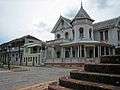 Casa Morales Marco (c.1915)
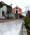 Convento de Porta Coeli (c.1606) overlooks Plaza Francisco Servera Silva
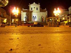 Church San Germán de Auxerre overlooks Plaza Francisco Mariano Quiñones
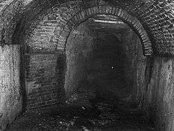 Los Túneles subterráneos de San Germán, vaulted brick storm sewer system built in 1835
References
- "National Register Information System". National Register of Historic Places. National Park Service. March 13, 2009.
- "San Germán Historic District". National Park Service. Archived from the original on 2009-04-30. Retrieved 2009-05-20.
- Rivero Méndez, Ángel (1922). "Crónica de la guerra hispano-americana en Puerto Rico". Wikisource (in Spanish). Retrieved 18 December 2019.
- Herrmann, K.S. (1900). From Yauco to Las Marias: Being a Story of the Recent Campaign in Western Puerto Rico by the Independent Regular Brigade, Under Command of Brigadier-General Schwan. R. G. Badger & Company. pp. 31–47. Retrieved 18 December 2019.
- "National Register of Historic Places Inventory/Nomination: San German Historic District". National Park Service. with photos
![]()
| Wikimedia Commons has media related to San Germán Historic District. |