Saint-Gotthard Massif
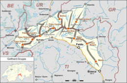
The Saint-Gotthard Massif (German: Gotthardmassiv or Sankt-Gotthard-Massiv) is a mountain range in the Alps in Switzerland, located at the border of four cantons: Valais, Ticino, Uri and Graubünden. It is delimited by the Nufenen Pass on the west, by the Furka Pass and the Oberalp Pass on the north and by the Lukmanier Pass on the east. The homonymous Gotthard Pass, lying at the heart of the massif, is the main route from north to south (excluding tunnels).
| Saint-Gotthard Massif | |
|---|---|
| German: Gotthardmassiv | |
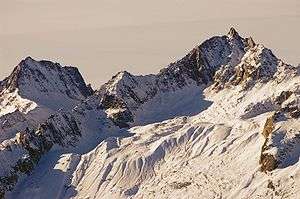 Pizzo Rotondo | |
| Highest point | |
| Peak | Pizzo Rotondo |
| Elevation | 3,192 m (10,472 ft) |
| Dimensions | |
| Length | 30 km (19 mi) |
| Geography | |
 | |
| Country | Switzerland |
| Cantons | |
| Parent range | Lepontine Alps |
| Borders on | Bernese Alps, Uri Alps and Glarus Alps |
Peaks
The highest peaks of the massif are Pizzo Rotondo[1] (3,192 m) in the southwest, Pizzo Centrale (2,999 m) near the centre and Piz Gannaretsch (3,040 m) in the northeast. There is no peak named Saint-Gotthard.
Tunnels
There are three long tunnels traversing the Saint-Gotthard Massif:
- Gotthard (Rail) Tunnel, railway culmination tunnel (1882, 15 km)
- Gotthard Road Tunnel, motorway tunnel (1980, 17 km)
- Gotthard Base Tunnel, railway lowest-level tunnel (2016, 57 km)
References
- Karl Baedeker, Switzerland and the Adjacent Portions of Italy, Savoy, and Tyrol, 1911, p. 154
This article is issued from Wikipedia. The text is licensed under Creative Commons - Attribution - Sharealike. Additional terms may apply for the media files.