Roumlouki
Roumlouki (Greek: Ρουμλούκι, from the Ottoman Turkish Rûmlık, "place of the Rûm")[1] or Kampania (Καμπανία), is the traditional name of the northeastern part of Imathia, specifically the plain of the lower Aliakmon River.
Location
The term refers to the lowlands between the Pierian Mountains in the south to the wetlands of the Giannitsa Lake (now drained) in the north, and from the heights east of Veroia to the mouths of the rivers Aliakmon and Loudias (Ottoman Kara Asmak) in the Thermaic Gulf. According to some accounts, the name extended up to the Axios River in the northeast.[1]
Settlements
The villages that traditionally were accounted as part of the region were Gidas (modern Alexandreia), Meliki, Koryfi, Nichori (Neochori), Reshina (Vrysaki), Nisi, Katafygi, Trichovista, Skylitsi, Kavasila, Stavros, Xechasmeni, Rapsomaniki, Pozarites (Kefalochori), Episkopi, Loutros, Kapsochora, Paliochora, Niseli and Niseloudi, Trikala, Karya, Aidonochori, Platy, Lianovergi, Paliochori, Gritzali (Agathia), Niochoropoulo, Prodromos, Niokastro, Voultista, Mega Alamboro (Prasinada) and Mikro Alamboro, Mylovos, Kouloura, Diavatos, Mikrogouzi (Makrochori), Metsi (Mesi), Ammos, Santena, Geraki, Mavrangeli, Barbesh or Koutlesh (Vergina), Trichlevo (Trilofo), Sfinista, Kleidi, Kaliani (Aloro), Tsinaforo (Platanos).[1] The actual number of settlements fluctuated, however, as some were abandoned and new ones founded because of the floods of the Aliakmon.[1]
Gallery
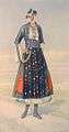 Traditional dress of a woman from the Roumlouki, by Nicolas Sperling
 Traditional dress of a woman from the Roumlouki, by Nicolas Sperling
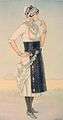 Traditional dress of a woman from the Roumlouki, by Nicolas Sperling
References
- "Ρουμλούκι" (in Greek). Municipality of Alexandreia. Archived from the original on 17 March 2017. Retrieved 17 March 2017.CS1 maint: BOT: original-url status unknown (link)