Rough River
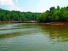
The Rough River is a 156-mile-long (251 km)[1] tributary of the Green River in west-central Kentucky in the United States. Via the Green and Ohio rivers, it is part of the watershed of the Mississippi River.[2] According to the Geographic Names Information System, it has also been known historically as "Rough Creek".[3]
Course
The Rough River rises in northwestern Hardin County and flows generally west-southwestwardly[4] through or along the boundaries of Grayson, Breckinridge, Ohio and McLean counties, past the town of Hartford. It joins the Green River at the town of Livermore, on the common boundary of McLean and Ohio counties.[2]
On the boundary of Breckinridge and Grayson counties, the Rough is dammed to form Rough River Lake. The lake collects the 29.5-mile-long (47.5 km)[1] North Fork Rough River,[5] which flows for its entire length in Breckinridge County.[2]
The Rough River has a mean annual discharge of 1,169 cubic feet per second[6] near Dundee.
See also
- List of Kentucky rivers
References
- U.S. Geological Survey. National Hydrography Dataset high-resolution flowline data. The National Map, accessed June 13, 2011
- DeLorme (2005). Kentucky Atlas & Gazetteer. Yarmouth, Maine: DeLorme. ISBN 0-89933-340-0.
- U.S. Geological Survey Geographic Names Information System: Rough River
- Columbia Gazetteer of North America entry
- U.S. Geological Survey Geographic Names Information System: North Fork Rough River
- https://waterdata.usgs.gov/ky/nwis/annual/?format=sites_selection_links&search_site_no=03319000&agency_cd=USGS&referred_module=sw