River Wansbeck
The River Wansbeck runs through the county of Northumberland, England. It rises above Sweethope Lough on the edge of Fourlaws Forest in the area known locally as The Wanneys (Great Wanney Crag, Little Wanney Crag; thus the "Wanneys Beck"); runs through the town of Ashington before discharging into the North Sea at Sandy Bay near Newbiggin-by-the-Sea.
| River Wansbeck | |
|---|---|
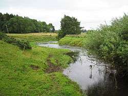 The River Wansbeck near Low Angerton | |
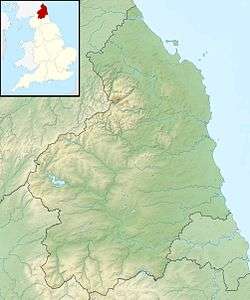 Location of mouth within Northumberland | |
| Location | |
| Country | United Kingdom |
| County | Northumberland |
| Physical characteristics | |
| Source | |
| • location | West of Sweethope Loughs |
| • coordinates | 55.1409°N 2.137°W |
| • elevation | 295 m (968 ft)[1] |
| Mouth | |
• location | North Sea |
• coordinates | 55.1619°N 1.5294°W |
| Length | 50 km (31 mi) [2] |
| Basin features | |
| Tributaries | |
| • right | River Font, Hart Burn |
The River flows through the village of Kirkwhelpington, the town of Morpeth, and the village of Mitford, where it is joined by a small tributary, the River Font.
The River Wansbeck is nicknamed the River Wanney. The term 'The Wilds of Wanney' is used by people of Tyneside to refer to the rural areas of Northumberland where the Wansbeck rises.
The River lent its name to the former Wansbeck district which was based in Ashington, and included Newbiggin-by-the-Sea, Bedlington and Stakeford.
Barrage and Navigation
Between 1974-75, a £250,000 barrage[3] with a navigation lock was built near the rivermouth and adjacent to the A189 road bridge.[4] In so doing the lower three miles of river[5] became a country park[6] and are recognised as England's most northerly inland (locked) navigation.[7] Very little use of the lock has actually been recorded although rowing and sailing craft are launched and used in the country park.
Stakeford bridge is about midway in the navigable part. Sheepwash Bridge is near the upper limit of the park and the navigable water.
From 1985 the new navigation was officially recorded in The Inland Waterways of Great Britain noting that the navigation authority was then Wansbeck District Council,[8] which means that since 2009 Northumberland County hold that role.
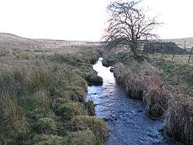 The infant River Wansbeck as a stream
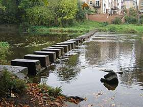 Stepping stones at Morpeth
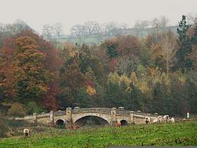 Wallington Bridge between Kirkharle and Cambo
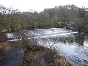 Weir at Mitford
 River Wansbeck meets the North Sea
Road & Rail River Crossings[9]
- North Seaton A189 Bridge, A189 (road, foot)
- North Seaton Railway Bridge (rail), used to carry Blyth and Tyne Railway now used for freight
- Stakeford Bridge, A196 (road, foot)
- Sheepwash Bridge, A1068 (road, foot)
- Bothal Mill Bridge, A196 (road, foot)
- Pegswood Railway Viaduct, East Coast Main Line (rail)
- Morpeth Telford Bridge, A197 (road, foot)
- Lowford Bridge, B6343 (road, foot)
- Highford Bridge, B6343 (road, foot)
- A1 Bridge (road)
- Mitford Bridge, B6343 (road, foot)
- Meldon Bridge (road, foot)
- Mill House Bridge, B6343 (road, foot)
- Low Angerton Bridge (road, foot)
- Low Angerton Railway Bridge (disused), Used to carry the Wansbeck Railway
- Middleton Bridge, B6343 (road, foot)
- Wallington Bridge, B6342 (road, foot)
- Kirkwhelpington Bridge (road, foot)
- Kirkwhelpington A696 Bridge (road)
- Sweethope Loughs Road Bridge (road, foot)
See also
- Rivers of the United Kingdom
References
- http://www.environmentdata.org/archive/ealit:1305/OBJ/19001149.pdf
- http://www.environmentdata.org/archive/ealit:1305/OBJ/19001149.pdf
- The barrage is a subject within this Durham University Doctoral thesis "Remediation Strategies and Water Quality of estuarine impoundments" by Jens Lamping retrieved 9 June 2014 from http://etheses.dur.ac.uk/3034/1/3034_1058.pdf?UkUDh:CyT . Page 107 of the thesis has a colour photo of the lock. The construction dates and details are sourced from the thesis p106-107
- See "Bridges on the Wansbeck North Seaton A189 bridge" retrieved 9 June 2014 from http://www.bridgesonthetyne.co.uk/northstn.html .Note that the bottom photo on that page shows the lock.
- Canal Plan AC Waterways > Mainland Britain > River Wansbeck retrieved 11 June 2014 from http://canalplan.org.uk/waterway/urwu .
- Northumberland County Council website Wansbeck Riverside Park page retrieved 9 June 2014 from http://www.northumberland.gov.uk/default.aspx?page=3521
- Jim Shead's River Wansbeck entry retrieved 9 June 2014 from http://www.jim-shead.com/waterways/river.php?wpage=WNSB&name=River%20Wansbeck
- Edwards, L. A.: The Inland Waterways of Great Britain, sixth edition Imray Laurie Norie & Wilson, St Ives, Cambs, 1985 p382.
- https://www.bridgesonthetyne.co.uk/intro5.html