River Lugg
The River Lugg (Welsh: Afon Llugwy) rises near Llangynllo, Powys. It flows through the border town of Presteigne, Wales then through Herefordshire, England, to the south of Leominster where it meets a tributary, the River Arrow. Its confluence with the River Wye is at Mordiford, 9 miles (14 km) downstream of Hereford and 45 miles (72 km) from its source.
| River Lugg | |
|---|---|
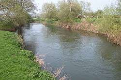 River Lugg at Hampton Bishop | |
| Native name | Afon Llugwy |
| Location | |
| Country | Wales, England |
| Counties | Powys, Herefordshire |
| Settlements | Llangynllo, Presteigne, Leominster, Hope under Dinmore, Bodenham, Marden, Lugwardine |
| Physical characteristics | |
| Source | Llangynllo |
| • location | Radnor Forest, Radnorshire, Powys, Wales |
| • coordinates | 52°21′29″N 3°12′20″W |
| • elevation | 497 m (1,631 ft) |
| Mouth | confluence with River Wye |
• location | Mordiford, Herefordshire, West Midlands, England |
• coordinates | 52°01′52″N 2°38′10″W |
• elevation | 46 m (151 ft) |
| Length | 72 km (45 mi) |
| Basin features | |
| Tributaries | |
| • left | River Frome |
| • right | River Arrow |
Navigation
The Environment Agency is the navigation authority for the river. Below Leominster the river was made navigable under the River Wye & Lugg Navigation Act 1696 for improving the River Wye and had pound locks. Despite several attempts to improve it, including making flash locks against bridges, the river was probably never satisfactory navigation. Commercial navigation probably ceased in the early 19th century. It is still sometimes used by small boats but can be very dangerous when in flood. In February 2020, it was one of several rivers with severe flood warnings following the impact of Storm Dennis.[1][2]
Recreation
The river is popular with canoeists who have undisputed rights of navigation.[3] It is a good fishing river.[4][5]
Footnotes
- "Storm Dennis: Fears for Severn towns amid fresh flood warnings". BBC News. Retrieved 18 February 2020.
- "Severe flood alerts in Monmouthshire, Herefordshire and Worcestershire as waters rise along River Wye, Lugg and Severn". Gloucestershire Live. Retrieved 18 February 2020.
- "UK Rivers website". Archived from the original on 17 October 2007. Retrieved 28 November 2007.
- "Total Fishing Gear". Archived from the original on 29 September 2007. Retrieved 28 November 2007.
- "Dwylon". Archived from the original on 27 September 2007. Retrieved 28 November 2007.
Further reading
- I. Cohen, 'The non-tidal Wye and its navigation' Trans. Woolhope Nat. Field. Club XXXV (1955-7), 83-101
- A. Brian, '"As to the Lugg": its vanished mills, broken weirs and damaged bridges’ Ibid. XLVIII(1) (1994), 36-96.
External links
| Wikimedia Commons has media related to River Lugg. |
| Authority control |
|
|---|