River Ash, Surrey
The River Ash is a small, shallow river in Surrey, England. Its course of 10 kilometres (6.2 mi) is just outside Greater London. Work has been carried out to re-align, clear, build up a small, central broader head of water and create very small corollary channels (anabranches) over centuries. It flows as one of the seven present distributaries of the River Colne from the south of Staines Moor immediately south of the Staines Bypass eastwards through the rest of the borough of Spelthorne before meeting the River Thames.
| River Ash | |
|---|---|
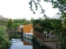
.jpg) Reach with wider banks, reeds and woodland close to Shepperton Studios | |
The southernmost inner west-east line marks the end of the river, the rest is wholly in the same Borough shown. | |
| Location | |
| Country/Nation | United Kingdom |
| Region/Country | England |
| County | Surrey |
| City | Sunbury=on-Thames, Shepperton, Littleton , Laleham, Ashford, Staines-upon-Thames |
| Physical characteristics | |
| Source | Sluice against lower River Colne |
| • location | Staines-upon-Thames, Spelthorne, England, United Kingdom |
| • elevation | 14 m (46 ft) |
| Mouth | River Thames |
• location | Sunbury-on-Thames and Shepperton, Spelthorne, England, United Kingdom |
• elevation | 8.6 m (28 ft) |
| Length | 10 km (6.2 mi) |
| Width | |
| • minimum | 2 feet (0.61 m) |
| • average | 6 feet (1.8 m) |
| • maximum | 20 feet (6.1 m) |
| Depth | |
| • minimum | 0.5 feet (0.15 m) |
| • average | 1.5 feet (0.46 m) |
| • maximum | 5 feet (1.5 m) |
| Basin features | |
| Progression | Colne—Ash—Thames |
| Artificial extra source: outflow of un-useable water from fresh waterworks | |
It is not navigable to craft and is rich in plant and insects, particularly reeds, diverse sedges (many of which commonly called bulrushes), pond-skaters and lepidoptera (moths and butterflies).
Course
The river is a distributary of the Colne. It forms the traditional boundary of Staines-upon-Thames first with Stanwell then with Ashford.[n 1][1] It then turns southward and splits Littleton (specifically the Queen Mary Reservoir, then a thin nature reserve by Shepperton Studios) from Laleham. It then resumes eastward. It is the northern limit of diminutive, near-square Shepperton Green — the western third of which was for centuries an southern outcrop (projection) of Littleton, and remains so in the Anglican church system.[2] Eighteen-hole Sunbury Golf Course on high-landscaped former municipal waste landfill then opposes a little of Shepperton across the banks. Then a farm of Green Belt straddles the river partly in outer lands of Sunbury-on-Thames. The river joins the Thames, flowing gently into the Creek – a secondary weirstream of the Thames – facing a long residential island: Wheatley's Ait.[3] It marks two streets' garden ends, many of which have built footbridges.[4] The five urban centres in the borough are well over 500 m away, which has spared it from pollution and supported its biodiversity. Three parks feature the river such as a long walk in Fordbridge Park, Ashford. Canoeists avoid the river when deep enough due to short barrages, extreme narrows and culverts.
Flow
In terms of flow of the seven distributaries, it is mid-ranked:
- flow exceeds:
- Sweeps Ditch, Staines (perhaps no longer a distributary of the Colne since building works in the 1970s)
- The long but ornamental Duke of Northumberland's River
- The Longford River.[n 2]
- flow normally dwarves:
- the short final main Colne channel
- the Colne Brook
- the River Wraysbury which just rejoins the Colne tens of metres from the Thames (so is more properly a later corollary) acting as a distributary.
Soil divide and water characteristics
Alluvium on gravel (save for London Clay outcrops, such as Harrow on the Hill, Hampstead Heath and the Grim's Ditch (Harrow)) is the soil setting of the north bank, west of the City of London as far as the Chiltern Hills.[5] As to topsoil the river marks a divide between permeable shallow gravelly topsoil for many miles to the north and almost impermeable alluvium to the south. A very thin, agriculturally prosperous alluvial belt by the River Thames 0.6 miles (0.97 km) to 3 miles (4.8 km) away was caused by deposition from seasonal floods.[6] This prevents for the whole course the rivers joining despite their proximity. As the gravel former terraces of the Thames very gently slope from north to south no abrupt halts to the water table exist no springs arise and only modest interaction with the Thames Basin's water table. The sources are water from the Colne and run-off principally of a fresh water waterworks. Water quality is ordinarily very clean given improvements in the effluent treatment works along the quite populous Colne valley – for a low-gradient river eutrophication and deposition is moderate to low.
History
Ashford gains its name from the river, forming the southern limit of all but its east (ex-manor demesne and common land). Maps featuring the Ash date to medieval times, showing course changes, some clearly man-made. The earliest known shows the history of various courses by Shepperton Studios (Littleton Manor demesne), a map commissioned by the Lord of Shepperton Manor, two miles to the south.[7] This refers to the monks of Westminster, who had widened (formed into fishable heads of water "pools" for much of this section.[8]
Since 1910 the ex-Metropolitan Water Board's Staines Aqueduct mirrors the west end of the Ash. This takes water from the Thames at Hythe End to works at Sunbury and Hampton. To cross this, the river is in a culvert or pipe at points next to: Birch Green; Shortwood Allotments; and Queen Mary Reservoir.
The mid-course was shifted a little west to make way for the Queen Mary Reservoir in Littleton. An slight trace of the original course is near the reservoir's pumping station.
In the early 1960s, the outflow (source) from the Colne was moved back south.[1] Further east; 100 metres is diverted to make way for the Staines Bypass (the A30). It then flows underground for 270 metres beneath the Crooked Billet roundabout.[9]
1947 and 2014 flooding
The narrow Ash floodplain flooded in 2014, on which a large minority of homes and outbuildings flooded. The previous such instance was in 1947[n 3] when inland flooding was widespread across the region. These were due to inadequate flood prevention measures of the Colne catchment, compounded by high water levels on the local parts of River Thames which flooded more homes and saw saturated water tables.
The local authorities after two years of exploring options, ruled out an inquiry to make effective recommendations due to their limited powers to investigate and control co-causatory entities including companies, chiefly upstream. Out of date records meant finding full causation was prohibitively complex.
Flood risk alleviation
Upgrade of the fresh water treatment works at Ashford Common (1994–95) by Thames Water Utilities caused greater steady outflow east of the M3. This heightened flood risk to properties abutting in Shepperton. Public budget work then arose, the River Ash Flood Alleviation Scheme of the Environment Agency. Deep holding troughs exist before the works run-off discharge and in Sunbury Golf Course a relief channel exists, bridged twice, built in January to May 1995 for £450,000.
Listed bridge
.jpg)
A long two-arch bridge has substantial neat (ashlar) stone-dressings, such as seven ballusters across six lightly recessed stone panels, each side, each arch. It has statutory protection and recognition in the initial starting category (Grade II), Squires Bridge. It was built in about 1870, partly by commission of the Wood family whose manor house standing at today's Shepperton Studios had a costly fire in 1874.[10] Its central newel (pilaster) as to its outer, upstream side has a coat of arms with three swords, not the family's which was that of a bull, instead that of Middlesex.[11]
See also
| Wikimedia Commons has media related to River Ash, Surrey. |
- List of rivers in England
- Tributaries of the River Thames
Notes and references
- Notes
- The traditional system was set aside for the takeover by civil (meaning non-ecclesiastical) administration in Victorian England. Somewhat due to civil parishes in England the medieval parishes are almost always identifiable settlements of the same name today.
- The Duke of Northumberland's River was not only used for its current garden lake feature use in Syon Park but also to top up the River Crane for the Shot Tower gunpowder mills, then in Hounslow Heath from the late 16th to late 18th centuries.
- See also, for example 1947 floods of the River Mole/River Ember
- References
- Ecclesiastical (Anglican) Parish Map of Staines St Mary & St Peter to which the west of Ashford Park including Staines Cemetery were added Church of England
- Ecclesiastical (Anglican) Parish Map of Littleton Church of England
- Grid square map TQ1068 Ordnance survey website
- Grid square map TQ0968 Ordnance survey website
- Robbins, Michael (2003) [1953]. Middlesex. Chichester: Phillimore. ISBN 9781860772696.
- Natural England - Geodiversity Archived 2 October 2013 at the Wayback Machine
- William Page (Editor) (1911). "Spelthorne Hundred: Littleton". A History of the County of Middlesex: Volume 2: General; Ashford, East Bedfont with Hatton, Feltham, Hampton with Hampton Wick, Hanworth, Laleham, Littleton. Institute of Historical Research. Retrieved 15 June 2013.CS1 maint: extra text: authors list (link)
- Grid square map TQ0768 Ordnance survey website
- Grid square map TQ0472 Ordnance survey website
- 'Spelthorne Hundred: Littleton', in A History of the County of Middlesex: Volume 2 ed. William Page (London, 1911), pp. 401-406. British History Online http://www.british-history.ac.uk/vch/middx/vol2/pp401-406 [accessed 1 August 2020].
- Historic England. "Details from listed building database (1188048)". National Heritage List for England.
See also
| Next confluence upstream | River Thames | Next confluence downstream |
| River Wey (south) | River Ash, Surrey | Longford River (north) |