Ringvassøya
Ringvassøya (Norwegian) or Ráneš (Northern Sami) is a large island in Troms og Finnmark county, Norway. It is divided between the municipalities of Tromsø and Karlsøy. Several islands surround Ringvassøya including Kvaløya to the south; Reinøya and Karlsøya to the east; Vannøya, Helgøya, and Nordkvaløya to the north; and Rebbenesøya to the north west. The island is connected to the neighboring island (and the rest of mainland Norway) by the Kvalsund Tunnel on the south shore of the island.[1]
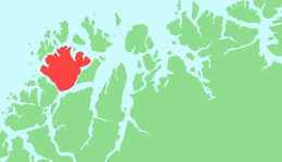 | |
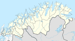 Ringvassøya Location of the island  Ringvassøya Ringvassøya (Norway) | |
| Geography | |
|---|---|
| Location | Troms og Finnmark, Norway |
| Coordinates | 69.8868°N 19.1729°E |
| Area | 663 km2 (256 sq mi) |
| Area rank | 6th largest in Norway |
| Length | 34 km (21.1 mi) |
| Width | 37 km (23 mi) |
| Highest elevation | 1,051 m (3,448 ft) |
| Highest point | Soltindan |
| Administration | |
Norway | |
| County | Troms og Finnmark |
| Municipality | Karlsøy and Tromsø |
| Demographics | |
| Population | 1,300 (2018) |
| Pop. density | 1.98/km2 (5.13/sq mi) |
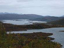
With an area of 663 square kilometres (256 sq mi),[2] Ringvassøy is the sixth largest island in mainland Norway. The island's highest point, Soltindan, has a height of 1,051 metres (3,448 ft) above sea level. The 10-kilometre (6.2 mi) long Skogsfjordvatnet is the largest lake on an island in Norway.[1]
The villages of Hansnes (the administrative centre of Karlsøy Municipality), Hessfjord, Indre Kårvik, and Skarsfjord are all located on the island. In 2018, there were about 1,300 people living on the island.[1]
See also
References
- Thorsnæs, Geir, ed. (2018-06-25). "Ringvassøya". Store norske leksikon (in Norwegian). Kunnskapsforlaget. Retrieved 2018-08-07.
- "Statistisk årbok 2009: Geografisk oversikt" (in Norwegian). Ssb.no. Retrieved 2010-08-01.