Røyrvik (village)
Røyrvik (Southern Sami: Raarvihke) is the administrative centre in Røyrvik municipality in Trøndelag county, Norway. The village is located in the central part of the municipality, about 20 kilometres (12 mi) west of the border with Sweden. It sits at the northern end of the large lake Limingen. Børgefjell National Park is located about 20 kilometres (12 mi) to the north. Røyrvik Church is located in the village.[3]
Village | |
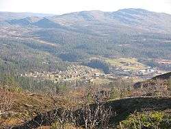 View of the village | |
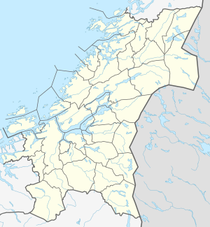 Røyrvik Location of the village  Røyrvik Røyrvik (Norway) | |
| Coordinates: 64.8839°N 13.5626°E | |
| Country | Norway |
| Region | Central Norway |
| County | Trøndelag |
| District | Namdalen |
| Municipality | Røyrvik |
| Area | |
| • Total | 0.38 km2 (0.15 sq mi) |
| Elevation | 425 m (1,394 ft) |
| Population (2018)[1] | |
| • Total | 247 |
| • Density | 650/km2 (1,700/sq mi) |
| Time zone | UTC+01:00 (CET) |
| • Summer (DST) | UTC+02:00 (CEST) |
| Post Code | 7898 Limingen |
The 0.38-square-kilometre (94-acre) village has a population (2018) of 247 and a population density of 650 inhabitants per square kilometre (1,700/sq mi).[1]
Name
The village (and municipality) is named after the old Røyrvik farm (historically: Røirviken), since the first church, Røyrvik Church, was built there (in 1828). The first element is røyr which means Arctic char and the last element is vik which means "inlet".[4]
References
- Statistisk sentralbyrå (1 January 2018). "Urban settlements. Population and area, by municipality".
- "Røyrvik (Trøndelag)". yr.no. Retrieved 2018-04-26.
- Rosvold, Knut A., ed. (2018-02-01). "Røyrvik – tettsted". Store norske leksikon (in Norwegian). Kunnskapsforlaget. Retrieved 2018-04-26.
- Rygh, Oluf (1903). Norske gaardnavne: Nordre Trondhjems amt (dokpro.uio.no) (in Norwegian) (15 ed.). Kristiania, Norge: W. C. Fabritius & sønners bogtrikkeri. p. 299.
| Authority control |
|
|---|