Rødøya
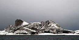
Rødøya is an island in the municipality of Rødøy in Nordland county, Norway. The 8.5-square-kilometre (3.3 sq mi) island is located just west of the mouth of the Tjongsfjorden, north of the island of Gjerdøya, and west of the mainland. There are ferry connections from the village of Rødøy to the village of Jektvika on the mainland and to the nearby island of Gjerdøya. Rødøy Church is located in the village of Rødøy on the south side of the island. The island had 150 residents in 2017.[1]
 | |
 | |
 Rødøya Location of the island  Rødøya Rødøya (Norway) | |
| Geography | |
|---|---|
| Location | Nordland, Norway |
| Coordinates | 66.6866°N 13.0769°E |
| Area | 8.2 km2 (3.2 sq mi) |
| Length | 5.2 km (3.23 mi) |
| Width | 2.5 km (1.55 mi) |
| Highest elevation | 443 m (1,453 ft) |
| Highest point | Rødøyløva |
| Administration | |
Norway | |
| County | Nordland |
| Municipality | Meløy Municipality |
| Demographics | |
| Population | 150 (2017) |
See also
References
- Thorsnæs, Geir, ed. (2017-07-14). "Rødøya – øy i Rødøy". Store norske leksikon (in Norwegian). Kunnskapsforlaget. Retrieved 2019-02-02.
This article is issued from Wikipedia. The text is licensed under Creative Commons - Attribution - Sharealike. Additional terms may apply for the media files.