Putāruru
Putāruru is a small town in the South Waikato District[2] of Waikato region of New Zealand's North Island. It lies on the western side of the Mamaku Ranges, on the upper basin of the Waihou River. It is on the Oraka Stream[3] 65 kilometres south-east of Hamilton. Both New Zealand State Highway 1 and the Kinleith Branch railway run through the town.
Putāruru | |
|---|---|
Town | |
 Putāruru Location in New Zealand | |
| Coordinates: 38°23′S 175°47′E | |
| Country | |
| Island | North Island |
| Region | Waikato |
| District | South Waikato District |
| Government | |
| • Territorial Authority | South Waikato District Council |
| • Regional Council | Environment Waikato |
| • Parliamentary electorate | Taupō |
| Population (June 2019)[1] | |
| • Total | 4,280 |
| Time zone | UTC+12 (NZST) |
| • Summer (DST) | UTC+13 (NZDT) |
| Postcode(s) | 3411 |
The town's population at the 2013 census was 3777[4] (2006: 3765, 2001: 3783, 1996: 4047). State Highway 1 and the Kinleith Branch railway run through the town.[5]
Name
The town gets its name from a historic event which occurred nearby. Korekore a granddaughter of Raukawa, the founder of the Ngāti Raukawa iwi, was murdered by her husband Parahore. Her servant Ruru witnessed her murder and escaped into the forest where he hid and waited for Parahore and his men to give up their pursuit of him. The place where he exited the forest was named "Te Puta a Ruru" or "the exit of Ruru". This was eventually shorted to Putāruru.[6][7]
History and culture
Pre-colonial history
There were several Māori settlements in the Putaruru district in pre-colonial times. Ngāti Raukawa is the main tribe or iwi in the area and Ngāti Mahana is the hapū (subtribe) within Putaruru. During Te Rauparaha's migration to the Cook Strait area in the 1820s, many Ngāti Raukawa people moved from these settlements to Rangitikei and Manawatu localities, and others followed after the Siege of Ōrākau in 1864. Te Kooti and his followers were pursued through the district early in 1870 by a force under Lt-Col. Thomas McDonnell.
European settlement
The Patetere Block, containing the future town site of Putaruru, was acquired from the Māori in the 1860s. In the early 1880s large areas in the Putaruru district came into the possession of the Patetere Land Company, and from 1883 much of this land passed into the hands of the Thames Valley Land Company. Roadmaking commenced in the late 1880s, but the railway, begun by the Thames Valley and Rotorua Railway Co., was the most important factor in the progress of settlement in the area.
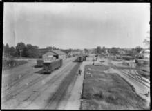
The line reached Oxford (Tīrau) on 8 March 1886 and Putaruru and Lichfield, 5 miles (8 km) further south-east, on 21 June 1886.[8] In 1889 the Putaruru-Rotorua section was begun, and was completed on 8 December 1894. The station had a refreshment room[9][10] and a bookstall[11] and the railway yard had a turntable[12] and handled much livestock,[13] as well as timber. In the 1920s a Railway Board investigated the feasibility of a line of about 28 mi 60 ch (46.3 km)[14] to Arapuni and Te Awamutu.[15] The station closed to passengers on 12 November 1968 and freight on 10 December 2002,[8] though it was served by the Geyserland Express from 1991 to 2001.[16]
The first settler in the district bought his section in 1892.
In the 1880s Putaruru consisted of little more than a hotel and a blacksmith shop. In the early 1900s the Taupo Totara Timber Company acquired bush blocks north and north-west of Lake Taupo and erected a mill at Kopokorahi, near the present Kinleith (Tokoroa). A bush tramway was constructed linking that mill with the Mokai Mill, 51 miles (82 km) south-east of Putaruru. By 1905 logs were transported to Putaruru via this line, and by 1908 passengers and goods. The dismantling of this line began in 1944 but in 1946 the Ministry of Works purchased it and in 1948 it began rebuilding the 18 miles (29 km) between Putaruru and Kinleith as a New Zealand Government Railways branch line to serve the new Kinleith Mill for pulp and paper production. This was completed on 6 October 1952.
Exotic afforestation was begun in the district some time after 1910 by a land and timber company with an outlet to the Hamilton-Rotorua railway near Pinedale. Commercial tree planting with Pinus radiata took place between 1924 and 1928 on the Pinedale Block. Milling began in 1940–41 and by 1951 the area had been cut out and replanted. Larger areas further south were planted in 1924 for future milling and to provide the raw material for pulp and paper manufacture. The town of Putaruru was surveyed in 1905 and on 18 December an area of 50,987 acres (206 km²), which had been acquired from the Thames Valley Land Co. by the Crown and included town allotments in Putaruru and Lichfield, was opened by ballot.
Much of the land in the Putaruru district suffered from a cobalt deficiency, which made farming practically impossible, but since 1935 measures have been taken to restore fertility, and farming has expanded. Putaruru was created a town district in 1926, and on 1 July 1947 it was constituted a borough.
Marae
The Putaruru area has two marae, affiliated with the hapū of Ngāti Raukawa:
Economy
Putaruru's economy is based on farming, forestry and timber production.[5]
The nearby Blue Spring is the current source of about 70% of New Zealand's bottled water.[19] Much of the town's water comes from the spring, which is on the Waihou River to the north east.[20]
Education
Putaruru Primary School is a co-educational state primary school on the main street, established in 1901,[21][22] with a roll of 166.[23]
Putaruru College is a co-educational state secondary school at the northern entrance of the town, by the Oraka River,[24] with a roll of 390.[25]
Te Wharekura o Te Kaokaoroa o Pātetere is a co-educational state primary school,[26] with a roll of 245.[27]
St Mary's Catholic School is a co-educational state primary school,[28] with a roll of 184.[29]
Notable people
- Grant Fox (born 1962), former All Black
- Glen Mitchell (born 1972), Olympic cyclist[30]
- Lorraine Moller (born 1955), Olympic athlete
- Gareth Morgan (born 1953), economist, philanthropist
- Wayne Smith (born 1957), former All Black and former All Black coach
References
- "Subnational Population Estimates: At 30 June 2019". Statistics New Zealand. 22 October 2019. Retrieved 11 January 2020.
- "Putaruru – South Waikato District Council". www.southwaikato.govt.nz. Retrieved 15 July 2018.
- "Oraka Stream, Waikato – NZ Topo Map". NZ Topo Map. Retrieved 15 July 2018.
- "Stats NZ Tatairamga Aotearoa".
- "Putaruru Travel Guide". Jasons Travel Media. Retrieved 30 September 2017.
- "About Putaruru – Pride in Putaruru". www.putaruru.co.nz. Retrieved 5 June 2020.
- Easther, Elisabeth (12 March 2015). "Kia ora: Putaruru". The New Zealand Herald. ISSN 1170-0777. Retrieved 5 June 2020.
- Scoble, Juliet (2010). "Names & Opening & Closing Dates of Railway Stations" (PDF). Rail Heritage Trust of New Zealand.
- "Fire on Railway Station". New Zealand Herald. 25 February 1925. p. 8. Retrieved 14 May 2018.
- "Appendix to the Journals of the House of Representatives — 1926 Session I — D-02 Page XLI Railways Statement by The Minister of Railways, The Right Hon. J. G. Coates". atojs.natlib.govt.nz. Retrieved 14 May 2018.
- "Railway Bookstalls". New Zealand Herald. 19 April 1929. p. 14. Retrieved 14 May 2018.
- "Appendix to the Journals of the House of Representatives — 1934 Session I — D-02 GOVERNMENT RAILWAYS BOARD (REPORT BY THE)". atojs.natlib.govt.nz. Retrieved 14 May 2018.
- "Putaruru Items". Auckland Star. 12 November 1936. p. 3. Retrieved 14 May 2018.
- "A Trip to Lichfield in the Patetere Country. [by Our Special Reporter.]". Waikato Times. 13 April 1886. p. 2. Retrieved 15 May 2018.
- "District News". Waikato Times. 13 November 1919. p. 9. Retrieved 14 May 2018.
- "bettertransport.org.nz • View topic – Inter-regional Rail service distances and times". www.bettertransport.org.nz. Retrieved 22 May 2020.
- "Te Kāhui Māngai directory". tkm.govt.nz. Te Puni Kōkiri.
- "Māori Maps". maorimaps.com. Te Potiki National Trust.
- "Brand Family". Aquasplash. Retrieved 30 September 2017.
- "Te Waihou Walkway". www.southwaikato.govt.nz. Retrieved 15 July 2018.
- "Putaruru Primary School Official School Website". putaruru.school.nz.
- "Putaruru Primary School Ministry of Education School Profile". educationcounts.govt.nz. Ministry of Education.
- "Putaruru Primary School Education Review Office Report". ero.govt.nz. Education Review Office.
- "Putaruru College Ministry of Education School Profile". educationcounts.govt.nz. Ministry of Education.
- "Putaruru College Education Review Office Report". ero.govt.nz. Education Review Office.
- "Te Wharekura o Te Kaokaoroa o Pātetere Ministry of Education School Profile". educationcounts.govt.nz. Ministry of Education.
- "Te Wharekura o Te Kaokaoroa o Pātetere Education Review Office Report". ero.govt.nz. Education Review Office.
- "St Mary's Catholic School Ministry of Education School Profile". educationcounts.govt.nz. Ministry of Education.
- "St Mary's Catholic School Education Review Office Report". ero.govt.nz. Education Review Office.
- Evans, Hilary; Gjerde, Arild; Heijmans, Jeroen; Mallon, Bill; et al. "Glen Mitchell". Olympics at Sports-Reference.com. Sports Reference LLC. Archived from the original on 18 April 2020. Retrieved 7 May 2017.