Pontrhydyfen
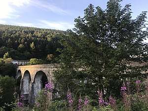
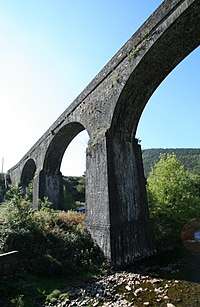
Pontrhydyfen (or Pont-rhyd-y-fen) (Google Map Satellite View) is a small village in the Afan Valley, in Neath Port Talbot county borough in Wales (grid reference SS794940). The village sits at the confluence of the River Afan and the smaller Afon Pelenna, 1.8 miles (2.9 km) north of the larger village of Cwmavon and not far from the towns of Port Talbot and Neath. The views from the village are dominated by the hills of Foel Fynyddau (370m) to the West, Moel y Fen (260m) to the South East and Mynydd Pen-rhys (280m) to the North. This former coal mining community is distinguished by two large 19th-century bridges that span the valley: a railway viaduct (the red bridge) and a former aqueduct, known in the Welsh language as Y Bont Fawr ("The Big Bridge").
Things to do / Amenities
- Afan Forest Park (Afan Forest Park Website)
- Mountain Biking. Home to the nearby Afan Forest Park (Windy Map showing Afan Forest Park Cycle Routes), the Valley offers the best places for mountain biking in South Wales and is consistently ranked highly within the best in the UK.[1][2]
- Walking
- Pontrhydyfen Community Centre
- Pontrhydyfen RFC [3]
History
The industrial history of Oakwood began in the 1820s when the first blast furnace was lighted for the Pontrhydyfen Iron Works [4] and coalmaster John Reynolds built the Aqueduct to power it. [5] By 1877 local Ordnance Survey maps show the site of the Iron Works as ruins [6] but there are continued historical references to the two blast furnaces at Pontrhydyfen until 1902.[4]
- The Red Bridge / Viaduct. The nine arch Pontrhydyfen viaduct built in 1898 was the last railway bridge built in the valley.[5]
- The Bont Fawr Aqueduct (aka The Big Bridge). Built by John Reynolds and completed in 1827, the four arch aqueduct is 153 yards (140 m) long and over 75 feet (23 m) high. A watercourse some two miles long carried water from the Afan, it supplied the water which powered the giant waterwheels of the Oakwood / Pontrhydyfen Ironworks.[5] Its use in supplying the waterwheels was relatively short lived and there is no record it being used for this purpose following the acquisition of the site by Governor and Company of Copper Miners in 1841.[7] The Bont Fawr Aqueduct is 'one of the few surviving structures relating to the use of water power in the iron industry in the region' and is a Grade II* listed building. [7] It remains in use today as a bridge for pedestrians and cyclists, the canal which it once carried having been filled in.
- Mining. George Yates' Map of the County Glamorgan shows Coal Pits just south of Oakwood on the West slopes of Moel y Fen and Mynydd Bychan by 1799. [8] By 1875 maps show a range of collieries including: Craig (SS 788933), Graiglyn (SS 788935) & Wernavon (SS 791936) on the South East slopes of Foel Fynddau each serviced by tramways, and Craig-y-fedw (SS 787947) on the East slope of Mynydd Hawdref [9] and then by 1914 maps show Oakwood Colliery (SS 799941) just to the South East of Rhyslyn Carpark. [10]
- Quarries. By 1897 maps show evidence of 3 quarries on Moel y Fen, 1 on Mynydd Hawdref (just West of Efail-fach), 2 on East slopes of Foel Fynyddau, 2 on the South slopes of Mynydd Pen-Rhys and 1 in the vicinity of Penhydd-fach.[11]
Famous people
Pontrhydyfen was the birthplace of actor Richard Burton[12], Broadway theatre and musical star Ivor Emmanuel who was also in Zulu[13], international opera singer Rebecca Evans[14], Welsh singer and songwriter Geraint Griffiths[15], and actor Mark Frankel. The Richard Burton Appreciation Society is based in the village.[16]
Points of Interest
The hills surrounding the village are home to a number of Mobile Phone Masts that are prominent markers on the horizon:[17]
| Site | Grid | Operator Ref | Mast Height | Type | Band |
|---|---|---|---|---|---|
| Cwmavon UHF Tranmitter - Moel y Fen | SS 79810 93600 | WGL7010 | 30m | GSM | 1800 MHz |
| Airwave Site - Foel Fynyddau | SS 78157 93690 | SWA096 | 29.5m | TETRA | 400 MHz |
| SIMOCO Transmitting Station - Foel Fynyddau | SS 78240 93600 | WGL0028 | 41m | GSM | 1800 MHz |
| SIMOCO Transmitting Station - Foel Fynyddau | SS 78240 93600 | WGL0028 | 41m | UMTS | 2100 MHz |
References
- Proviz Sports. 2019. Top 15 Mountain Bike Trails in the UK 2020. [ONLINE] Available at: https://www.provizsports.com/en-gb/blog/top-15-uk-mountain-bike-trails. [Accessed 14 March 2020].
- naturalresources.wales : Afan Forest Park Retrieved 13 March 2020
- Pontrhydyfen RFC Website
- Grace's Guide: Pontrhydyfen/ Oakwood Iron Works. Retrieved 11 April 2020
- Afan Valley Then & Now. Retrieved 13 March 2020
- Ordnance Survey Map (1874-77). Retrieved 11 April 2020
- Wales Online - An iconic Welsh aqueduct has been painstakingly restored by Gemma Parry. Retrieved 9 April 2020
- The National Library of Wales - George Yates' Map of the County Glamorgan (1799). Retrieved 12 April 2020
- The National Library of Scotland - Ordnance Survey Map of Glamorgan Sheet XXV. N.E. (Revised 1897). Retrieved 13 April 2020
- The National Library of Scotland - Ordnance Survey Map of Glamorgan Sheet XXV. N.E. (Revised 1914). Retrieved 13 April 2020
- The National Library of Scotland - Ordnance Survey Map of Glamorgan Sheet XXV. N.E. (Revised 1914). Retrieved 14 April 2020
- The Official Richard Burton Website. Commissioned by Onward Productions. Retrieved 1 April 2020
- BBC's Phil Carradice (2013) The life and times of Ivor Emmanuel. Retrieved 1 April 2020
- BBC Website. Wales Music Biography Rebecca Evans. Retrieved 1 April 2020
- BBC Lleol. De Orllewin Cantorion Geraint Griffiths. Retrieved 1 April 2020
- Facebook Group. The Richard Burton Appreciation Society. Retrieved 1 April 2020
- OFCOM (2012) Sitefinder May 2012 dataset