Phantom island
A phantom island is a purported island which appeared on maps for a period of time (sometimes centuries) during recorded history, but was removed from later maps after it was proven not to exist.
Possible origins
Phantom islands usually stem from the reports of early sailors exploring new realms. Some may have been purely mythical, such as the Isle of Demons. Others arose through the faulty positioning of actual islands, or other geographical errors. Pepys Island was actually a misidentification of the Falkland Islands. The Baja California Peninsula appears on some early maps as an island, but was later discovered to be attached to the mainland of North America. Similarly, the Banks Peninsula, part of the South Island of New Zealand, was originally called "Banks Island" by Captain James Cook. Thule was perhaps actually discovered in the 4th century BC by the Greek explorer Pytheas but was lost, and then later reidentified by ancient explorers and geographers as either the Shetland Islands, Iceland, Scandinavia, or even as nonexistent.
Other phantom islands are probably due to navigational errors, occasional breakers, misidentification of icebergs, fog banks, pumice rafts from underwater volcanoes[1] or optical illusions. Observed in the Weddell Sea in 1823 but never again seen, New South Greenland may have been the result of a superior mirage. Even deliberate fabrication has been suggested.[2][3]
Lake Superior's Isle Phelipeaux, an apparent duplication of Isle Royale[4] which appeared on explorers' maps for many years and served as a landmark for the original border between the United States and the territory that would become Canada, was named for Louis Phélypeaux, a government minister influential in allocating funds for additional voyages of exploration.
While many phantom islands appear never to have existed, a few (such as Thompson Island or Bermeja) may have been actual islands subsequently destroyed by volcanic explosions, earthquakes, submarine landslides, or low-lying lands such as sand banks that are no longer above water. Pactolus Bank, visited by Sir Francis Drake, may fit into this category.
List of phantom islands
| Name | "Discovery" date |
Notes |
|---|---|---|
| Antillia | 714/15th century | The island, like the more popular Atlantis, is a fictional island in the Atlantic originating from an Iberian legend. |
| Atlantis | 360 BC | Ancient Greek legend described by Plato, later hypothesized to be real, and depicted on a 1664 map by Athanasius Kircher. |
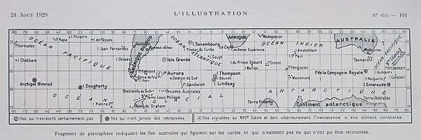
| Aurora Islands | 1762 | Discovered by Spanish merchant ship Aurora, currently thought to be just Shag Rocks. |
| Bacalao | 1472 | Gaspar Frutuoso noted its discovery by João Vaz Corte-Real in 1472 in Saudades da Terra. |
| Bermeja | 1539 | Discovered in the early 16th century by Spain, but mysteriously vanished sometime during the 17th century. While no dominant theory holds, it is possible that the island submerged due to tectonic movements, supported by the existence of a seamount at 22°38.76′N 90°51.3′W and the nearby Scorpion Reef. |
| Brasil (or Hy-Brasil) | 1325 | Said to lie in the Atlantic Ocean west of Ireland. Irish myths described it as cloaked in mist except for one day every seven years, when it became visible but still could not be reached. |
| Saint Brendan's Island | 512 | Claimed to have been first visited in 512 by the monk St. Brendan and 14 others, along with later reports up to 1772. |
| Buss Island | 1578 | Found in the waters near Greenland, in which Martin Frobisher, the leader of the island-finding expedition, probably made a mistake in dead reckoning and mistook optical effects near Greenland for a new island. |
| Island of California | 1510 | A misconception about the Baja California Peninsula being an island due to an assumption that the Gulf of California was instead a strait separating California from the rest of the Americas. |
| Crockerland | 1906 | A hoax invented by the famous Arctic explorer Robert E. Peary to gain more financial aid from George Crocker, one of his financial bankers. |
| Davis Land | 1687 | Supposedly sighted by the pirate Edward Davis in the Pacific along the southern latitude of 27 to 28 degrees, which was on the same latitude as the Spanish-controlled gold mines of Copiago. At the time, it was believed that gold could be found elsewhere along the latitude so several navigators were instructed to seek it out on their voyages. Never found, it was also believed by William Dampier to be the coast of Terra Australis Incognita.[5] |
| Isle of Demons | 1508 | Probably a relocated version of the island of Satanazes (see island below). |
| Dougherty Island | 1841 | Because it is near Antarctica, it is likely that the discoverer, Captain Dougherty, and future explorers who confirmed it, saw fog banks and icebergs conveniently situated in the right place and time. |
| Elizabeth Island | 1578 | Described by Francis Drake, who reported harbouring there during his circumnavigation. Not found by subsequent explorers; in 1939 Felix Riesenberg suggested Pactolus Bank as a possible remnant, though recent surveys suggest the Bank may itself be a phantom feature. |
| Emerald Island | 1821 | Probably fog banks and icebergs (see Dougherty Island above); the abyssal plain below it was named Emerald Plain, however, in recognition of the nonexistent island. |
| Ernest Legouve Reef | 1902 | A reef supposedly found by the captain of the French ship, Ernest Legouvé, which is near the exact location of the fictional Lincoln Island, the main setting for Jules Verne's book The Mysterious Island, also appearing in In Search of the Castaways. |
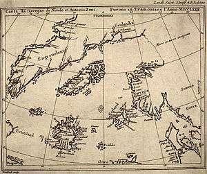
| Estotiland | 1558 | An island appearing on the Zeno map at the current location of Labrador. |
| Fata Morgana Land | 1907 | J.P. Koch, together with Aage Bertelsen, was reported to have first seen Fata Morgana Land (Danish: Fata Morgana Landet) lying in the Arctic Ocean around 80°00´N 10°00´W between NE Greenland and Svalbard. This elusive land was allegedly seen as well by Lauge Koch from the air in 1933.[6] |
| Filippo Reef | 1886 | This reef, part of the Line Islands, was first seen by the ship Filippo and was seen again in 1926 when both ships saw breakers in the same area, suggesting a depth of 0.6 to 0.9 metres (2.0 to 3.0 feet). Current observations show the reported location to have a depth of 3.3 miles (5.3 kilometres), and the nearest shallow seamount is about 2.9 miles (4.7 kilometres) deep, disproving the existence of the island. |
| Frisland | 1558 | Another island on the Zeno map, possibly a renamed Iceland. |
| Ganges Island | 20th century | A nonexistent island off the coast of Japan to the southwest of the Shatsky Rise. |
| Groclant | 1569 | An island to the west of Greenland, perhaps a misreading of the island's name, or Baffin Island. |
| Ilha de Vera Cruz | 1500 | A supposed 'island' found by Portuguese explorers, which turned out not to be an island but rather what is currently known as Brazil. |
| Jacquet Island | Middle Ages | An island just to the east of the Flemish Cap; it was believed to exist into the 19th century, during which cartographers discussed it as a possible midway point for the Transatlantic telegraph cable. |
| Juan de Lisboa | 17th century | Reported on maps as being southeast of Madagascar. |
| Jupiter Reef | 1878 | Nonexistent reef in the Line Islands (in fact Line Islands are more than 2,000 miles (3,200 kilometres) away), to the south of the also nonexistent Ernest Legouve Reef (see above). |
| Kantia | 1884 | Found in 1884 by Johan Otto Polter, who, in four later expeditions through 1909, disproved the island's existence. |
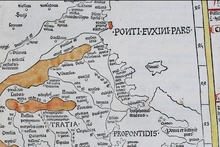
| Kianida Island or Cianeis Insula | 1467 | Supposedly known in Antiquity, a large island the size of Thassos but situated off the Black Sea coast of Thrace in the present Bulgaria-Turkey border area. Depicted on the 1467 map Nona Europae Tabula by Nicolaus Germanus based on Claudius Ptolemy's Geography.[7] According to Bulgarian geomorphologist Dinyo Kanev, probably destroyed by sea in the Middle Ages.[8] |
| Los Jardines | 1528 | A pair of phantom islands to the east of the Marshall Islands. |
| Isle of Mam | 1367 | A crescent-shaped island in the North Atlantic that does not appear to exist; however, there is a crescent-shaped group of seamounts 120 feet deep near its described location. |
| María de Lajara or Maria Laxar | 17th century | Usually located northeast from Hawaii, but perhaps originally one of the Bonin Islands. |
| Maria Theresa Reef (aka Tabor Island or Tabor Reef) | 1843 | Another nonexistent reef in the Line Islands (in fact Line Islands are more than 2,000 miles (3,200 kilometres) away), slightly to the southwest-west of the phantom island, Jupiter Reef. It is a setting for Jules Verne's book In Search of the Castaways. |
| St. Matthew Island | 1516 | An island near the coast of Africa, roughly 1,000 kilometres (620 miles) east-northeast of Ascension Island and possibly confused with the same latitude Annobón Island. |
| New South Greenland | 1823 | Unknown odd island near Antarctica, which captain Benjamin Morrell of the ship Wasp saw while traveling north from Antarctica. He thought it to be the Antarctic Peninsula (then called New South Greenland), but his reported location during the voyage, while perfectly copying the expected path for traveling up the peninsula, was over 310 miles (500 kilometres) to the east and 60 miles (97 kilometres) to the north of the actual position of the Antarctic Peninsula, suggesting either a huge miscalculation in location or sightings of icebergs and fog, typical of phantom islands in the Antarctic Circle. |
| Nimrod Islands | 1828 | A group of islands between Emerald Island and Dougherty Island, both of which are nonexistent. Probably a group of icebergs together. |
| Pactolus Bank | 1885 | An oceanic bank 400 feet (120 metres) deep off the west coast of Cape Horn, suggested as the remains of Elizabeth Island: However a 1956 search of the area turned up no shallow areas in the reported location. |
| Pepys Island | 1683 | In 1683, Ambrose Cowley reported an unknown island where he thought the Falklands were, but his location was 4 degrees to the north of the Falkland Islands. While it is possible that he made a mistake in seeing a nonexistent island, it is more likely he saw one of the Falkland Islands and made a 4-degree error in his location. |
| Petermannland | Between 1860 and 1874 | North of Zemlya Frantsa-Iosifa, named after August Heinrich Petermann. |
| Isle Phelipeaux | 1744 | A nonexistent island in Lake Superior referenced in the 1783 Treaty of Paris. |
| Podesta | 1879 | An island 1,390 kilometres (860 miles) to the west of El Quisco, Chile, that was discovered to be fake in 1935 and promptly removed. Other phantom islands were also found in the vicinity in 1912 and 1858 (see Sarah Ann Island). |
| Rivadeneyra Shoal | 1842 | A shoal in the eastern Pacific Ocean. |
| Royal Company's Islands | Before 1840 | A fictional island widely believed during the 19th century to be to the southwest of Tasmania. While not found by numerous expeditions in 1840, 1889, 1902, 1909, and 1912, the island was not officially removed from nautical charts until 1904. |
| Royllo | 1424 | A small island to the west of the mythical Antillia (see Antillia above). |
| Rupes Nigra | 14th century | A magnetic, black island at the exact Magnetic north, invented as an explanation for why all compasses point north. |
| Sandy Island | 1774 | Another phantom, small island to the west of New Caledonia that was recorded on many maps until 2012, when a surveying ship passed by and disproved its existence. The current leading explanation is that the island was a raft of buoyant pumice from a recent nearby seamount eruption. |
| Sannikov Land | 1809 | An island near the De Long Islands, north of Russia, that probably did exist but was destroyed due to coastal erosion. |
| Sarah Ann Island | 1858 | A phantom island near Easter Island, similar to Podesta island. See Operational Navigation Chart of the United States Department of Defense. |
| Satanazes | 1424 | This island was originally noted on maps in 1424, originating from popular legend of devils and demons attacking ships that went into the area, but the island was subsequently removed because it obviously did not exist. The island, often drawn to the north of the mythical Antillia, was purportedly full of evil demons but was sometimes called Salvaga to avoid using the profanity "devil". |
| Saxemberg Island | 1670 | An odd island midway between South America and Africa that numerous captains reported seeing in 1804, 1809, and 1816. While most had conflicting reports, all of them found the island in the same location; however, none of them actually made landfall. It is possible the island was volcanic and later erupted and destroyed itself. It is also possible that they were looking at Tristan de Cunha island. |
| Schjetman Reef | 1868 | To the west of the Hawaiian Islands, Schjetman Reef was originally found in 1868 to be an island 1.5 nautical miles long and 0.5 nautical miles wide. Later searches in 1880, 1923, and 1924 could not find the island. |
| Sefton Reef | 1808 | Approx. 83°W, 37°S (southwest of Robinson Crusoe Island), noted as "position doubtful" in Operational Navigation Chart[9] of the United States Department of Defense. |
| Terra Nova Islands | 1961 | Thought to lie off Oates Coast, East Antarctica. |
| Thompson Island | 1825 | An island in the south Atlantic Ocean discovered by the whaling ship captain George Norris; it has not been seen since 1893. |
| Thule | 325 BC | A mythical island in the far north that is mentioned many times in Roman- and Medieval-period works. Current interpretations guess it to be Norway, Orkney, Shetland, Scandinavia, Iceland, Greenland, and even Saaremaa. |
| Torca Island | 1693 | A mythical island near Ambon in the East Indies purportedly destroyed by a volcanic eruption. |
| Transit Reef | 18th century | A possible reef in Southern Palau. While this reef probably exists, some maps do not list it as an actual location, and, although the reef doesn't have any land, the native name of the island, Pieraurou, means 'Sandy Navigation Point', implying a sandy island or sand bar. |
| Tuanaki | 1842 | A vanished group of islets in the Cook Islands at which a sailor allegedly spent 6 days, but a ship traveling in the waters two years later found no island. |
| Wachusett Reef | 1899 | A nonexistent reef in the Line Islands (in fact Line Islands are more than 2,000 miles (3,200 kilometres) away) along with Ernest Legouve Reef, Jupiter Reef, and Maria Theresa Reef. This reef, the largest of the three, was thought to be 30–35 feet (9.1–10.7 metres) deep. None of these reefs are currently believed to have actually existed. |
| Yosemite Rock | 1903 | Approx. 83°W, 32°S (northwest of Robinson Crusoe Island), noted as "Existence doubtful" in Operational Navigation Chart of the United States Department of Defense. |
| Zanara | 1589 | An island situated in front of Monte Argentario, in the Tyrrhenian Sea between the Isola del Giglio and Giannutri. It was reported for the first time by the cartographer and astronomer Gerardus Mercator in 1589 and subsequently reported in numerous ancient maps by illustrious cartographers until 1720.[10] |
See also
References
- Seton, Maria; Williams, Simon; Zahirovic, Sabin (9 April 2013). "Obituary: Sandy Island (1876 –2012)". Eos, Transactions, American Geophysical Union. 94 (15): 141–148. doi:10.1002/2013eo150001. ISSN 2324-9250.
- Antarctica, p. 47, Paul Simpson-Housley, 1992
- Exploring Polar Frontiers, p. 435, William James Mills, 2003
- Canada and its Provinces. 1914.
- Dunmore, John (2016). Chasing a Dream: The Exploration of the Imaginary Pacific. Auckland: Upstart Press. pp. 81–82. ISBN 978-1-927262-79-5.
- "Catalogue of place names in northern East Greenland". Geological Survey of Denmark. Retrieved 21 April 2016.
- Germanus, Nicolaus, ed. (1482), Claudii Ptolomei Viri Alexandrini Cosmographie Octavus et Ultimus Liber Explicit Opus, Ulm: Leinhart Holle
- Dikov, Ivan. Roman Era Map Shows Large Now-Sunken Island Off Black Sea Coast. Brewminate, 23 June 2018
- "Photographic image of Relief Portrayal : ONC R-22" (JPG). Lib.utexas.edu. Retrieved 2016-10-01.
- "Isola di Zanara (in italian)". Maremmanews.it. 2017-06-10. Retrieved 2019-03-01.
Further reading
| Wikimedia Commons has media related to Fictional islands. |
- "Thompson Island". Archived from the original on 2009-04-19.
- Stommel, Henry (1984). Lost Islands: The Story of Islands That Have Vanished from Nautical Charts. Vancouver: University of British Columbia Press. ISBN 978-0-7748-0210-9.
- Gaddis, Vincent, Invisible Horizons, Chilton Books. New York. 1965.
- Clark Barnaby Firestone, The Coasts of Illusion: A Study of Travel Tales, Harper Books, 1924.
- Johnson, Donald S., Phantom Islands of the Atlantic, Walker Publishing, New York, 1996 (Rev. ed.)
- William Shepard Walsh, A Handy Book of Curious Information, J. B. Lippincott, 1913.
- Dirk Liesemer, Lexikon der Phantominseln. mareverlag, Hamburg 2016, ISBN 978-3-86648-236-4
- Ramsay, Raymond (1972). No Longer on the Map. New York: Viking Press. ISBN 978-0-670-51433-5.
- Gould, Rupert T. (1928). "The Auroras, and Other Doubtful Islands". Oddities: A Book of Unexplained Facts. Kessinger Publishing. pp. 124–163.