Pennsylvania Route 132
Pennsylvania Route 132 (PA 132) is a state highway in southeast Pennsylvania. It runs northwest to southeast through Bucks County in suburban Philadelphia from PA 611 in Warrington southeast to Interstate 95 (I-95) in Bensalem. It is a commercial route lined with shopping centers throughout much of its 15-mile (24 km) length. It is named Street Road and is five lanes wide for much of its length. It was also designated as the Armed Forces and Veterans Memorial Highway in 2005. From west to east, it crosses PA 263 and PA 332 in Warminster, PA 232 in Southampton, PA 532 in Feasterville, and U.S. Route 1 (US 1), the Pennsylvania Turnpike (I-276), PA 513, and US 13 in Bensalem. Street Road was included in William Penn's survey plans and completed by 1737. The road was paved by 1911 and received the PA 132 designation by 1927. The road was widened into a multi-lane highway and extended to I-95 by 1970. An E-ZPass-only interchange with the eastbound direction of the Pennsylvania Turnpike opened in 2010.
| ||||
|---|---|---|---|---|
| Street Road Armed Forces and Veterans Memorial Highway | ||||
 Map of northern suburbs of Philadelphia with PA 132 highlighted in red | ||||
| Route information | ||||
| Maintained by PennDOT | ||||
| Length | 15.155 mi[1] (24.390 km) | |||
| Existed | by 1927[2]–present | |||
| Major junctions | ||||
| West end | ||||
| East end | ||||
| Location | ||||
| Counties | Bucks | |||
| Highway system | ||||
| ||||

Route description
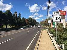
PA 132 begins at an intersection with PA 611 (Easton Road) in Warrington Township, heading to the southeast on Street Road, a four-lane road that alternates between a divided highway and an undivided five-lane road including a center left-turn lane. West of PA 611, Street Road continues as State Route 3001 (SR 3001), an unsigned quadrant route, to Lower State Road. From its western terminus, the route heads through commercial areas before crossing the Little Neshaminy Creek and entering residential areas. At the Valley Road intersection, the road crosses into Warminster Township and continues through suburban development as West Street Road. PA 132 enters commercial areas as it comes to a junction with PA 263 (York Road). Farther southeast, the road intersects Mearns Road. After crossing the New Hope Railroad at-grade about 300 feet (91 m) north of that railroad meeting SEPTA's Warminster Line, the route passes through industrial and business areas before intersecting PA 332 (Jacksonville Road).[3][4]
Past the PA 332 intersection, the road continues through a mix of homes and businesses as East Street Road. Upon crossing Davisville Road, PA 132 enters Upper Southampton Township and intersects Maple Avenue as it passes more businesses as Street Road. The road crosses PA 232 (Second Street Pike) in the community of Southampton before passing over SEPTA's abandoned Fox Chase/Newtown Line and reaching an intersection with Knowles Avenue/Churchville Road. After running through wooded residential areas, the road crosses into Lower Southampton Township at the Stump Road intersection and passes under Norfolk Southern's Morrisville Line.[3][4]

Street Road continues past a mix of residential and commercial development as it comes to an intersection with PA 532 (Bustleton Pike) in the community of Feasterville. After the PA 532 junction, the road heads past several businesses before turning south-southeast near more suburban development. PA 132 turns southeast again and crosses Philmont Avenue prior to entering Bensalem Township. Upon entering Bensalem, the route passes over SEPTA's West Trenton Line on a bridge and intersects Trevose Road as it enters commercial areas again in the community of Trevose. After a bridge over CSX's Trenton Subdivision, PA 132 crosses under the Pennsylvania Turnpike (I-276) immediately before an intersection with Old Lincoln Highway, becoming a divided highway.[3][4]
A short distance later, the road reaches a partial cloverleaf interchange with US 1, with all movements complete except a ramp from eastbound PA 132 to southbound US 1, before turning south. The route comes to an E-ZPass-only ramp that provides access to and from the eastbound Pennsylvania Turnpike (I-276); this ramp has no access from eastbound PA 132. PA 132 continues south-southeast past more businesses, becoming an undivided road again past the Richlieu Road intersection and passing two entrances to Parx Casino and Racing and the Bucks County Visitor Center to the northeast of the road. The road gains a center left-turn lane and heads past more commercial development, crossing Mechanicsville Road and Knights Road before coming to the PA 513 (Hulmeville Road) intersection. Farther southeast, PA 132 reaches a partial cloverleaf interchange with US 13 (Bristol Pike) before ending at a diamond interchange with I-95 just north of the Eddington station along SEPTA's Trenton Line that follows Amtrak's Northeast Corridor. Past I-95, Street Road passes over the Northeast Corridor and continues as SR 2007 to State Road.[3][4]
In 2016, PA 132 had an annual average daily traffic count ranging from a high of 54,000 vehicles between Trevose Road/Old Street Road and Old Lincoln Highway to a low of 25,000 vehicles between Maple Avenue and Knowles Avenue/Churchville Road.[5] The entire length of PA 132 is part of the National Highway System.[6]
History
Street Road was originally surveyed in the late 17th century, with the road being included in the original survey plans of William Penn for the Province of Pennsylvania. For much of its history it has been known as "the Street road".[7] It was called this because, contrary to present usage where "street" is a synonym for road, the original use of the word "street" was a paved road.[8] The entire length of the road was completed by 1737.[9] Street Road became a paved road by 1911; at the time, the route was not defined as a legislative route.[10] By 1927, PA 132 was designated onto part of Street Road, running from US 611 (now PA 611) in Warrington Township southeast to US 13 in Bensalem Township.[2]

In February 1950, two traffic signals were installed along the road in Bensalem.[11] Street lights were installed along the stretch of PA 132 in Bensalem in December 1952.[12] In August 1956, Bensalem police chief William Riempp urged for the stretch of Street Road through the township to be completely reconstructed as it was one of the most dangerous roads in the state.[13] The state widened the portion of PA 132 through Upper Southampton and Lower Southampton townships from 22 feet (6.7 m) to 24 feet (7.3 m) in 1956; this widening was called a "useless waste of public funds" by the Lower Southampton Township planning commission as the road was not anticipated to handle increasing traffic volumes.[14] The portion of Street Road between US 1 and US 13 in Bensalem Township was repaved in mid-1957; however the shoulders were not repaved, resulting in a drop between the travel lanes and the shoulder.[15] In August 1958, the Pennsylvania State Highway Department (PDH) considered reducing the speed limit on the two-lane stretch of PA 132 between Davisville Road and Gravel Hill Road in Upper Southampton Township in order to make the road safer.[16]
On January 9, 1960, the PDH awarded a contract worth $1,488,493 to James D. Morrisey, Inc. to upgrade the section of PA 132 between Neshaminy and Warminster to a four-lane divided highway.[17] In November 1961, the portion of Street Road southeast of US 13 was closed to allow for construction of I-95 (Delaware Expressway), which would include an interchange with Street Road; this interchange was planned to be completed in 1962.[18] In January 1962, a proposal was made to split PA 132 onto separate roadways through Feasterville, with the westbound direction using Irving Place a block north of Street Road.[19] In January 1963, plans were made to widen the entire length of PA 132 to 80 feet (24 m) with a median strip, with a portion in Feasterville to be widened to 71 feet (22 m). The widening was originally planned to be completed in 1965.[20] By March of that year, the widening project was shelved as the state felt they should receive federal funds to fund the project.[21] With the widening shelved, businesses from Feasterville and Southampton along with State Senator Marvin Keller led a push to get the portion of Street Road through the two communities paved, which was in disrepair and saw a lot of accidents.[22]
In May 1965, construction began to widen the portion of PA 132 between US 1 and US 13 in Bensalem to a four-lane divided highway.[23] On August 27, 1965, a 2-mile (3.2 km) stretch of new concrete pavement along PA 132 in Bensalem was completed, with work then to begin on rebuilding the original roadway to make it a divided highway.[24] The widening of Street Road into a divided highway between US 1 and US 13 was completed in December 1965.[25] The proposed widening of PA 132 in Feasterville drew concerns from residents who feared they would lose their homes.[26] In July 1967, the state made plans to add left turn lanes at PA 132's intersections with US 611 in Warrington and PA 263 in Warminster in order to reduce crashes.[27] In 1969, work was underway in widening Street Road between PA 263 and PA 332 in Warminster.[28] The widening of PA 132 into a divided highway was completed in 1970. As a result of this improvement, a portion of the road was relocated east of Feasterville, with the former alignment becoming Old Street Road. Also by this time, the route was extended southeast to an interchange with I-95.[29]

In May 1971, plans were announced to install a traffic signal at PA 132 and Mechanicsville Road in Bensalem Township, an intersection that saw many accidents.[30] Plans were discussed in September 1975 to reconstruct PA 132 to handle increasing traffic volumes, with work projected to begin between 1977 and 1980.[31] On November 22, 1976, Warminster Township supervisors voted against building sidewalks and curbs on a portion of Street Road in the township in order to not burden taxpayers.[32] In 2005, a bill was introduced into the Pennsylvania General Assembly designating the entire length of PA 132 as the Armed Forces and Veterans Memorial Highway; this bill was signed into law by Governor Ed Rendell on October 27, 2006.[33][34] On May 28, 2007, PA 132 was officially named the Armed Forces and Veterans Memorial Highway in a ceremony held in Warminster, with State Representative Kathy Watson in attendance.[35] On November 22, 2010, an E-ZPass-only ramp with access to and from the eastbound Pennsylvania Turnpike in Bensalem Township opened, intended to provide improved access to Parx Casino and reduce congestion at the Pennsylvania Turnpike interchange with US 1.[36] The intersection of PA 132 and Knights Road in Bensalem Township was ranked by Time magazine as the most dangerous intersection in the United States from 2003 until 2012.[37]
Major intersections
The entire route is in Bucks County.
| Location | mi[1] | km | Destinations | Notes | |
|---|---|---|---|---|---|
| Warrington Township | 0.000 | 0.000 | Western terminus | ||
| Warminster Township | 2.589 | 4.167 | |||
| 3.748 | 6.032 | ||||
| Upper Southampton Township | 6.304 | 10.145 | |||
| Lower Southampton Township | 9.033 | 14.537 | |||
| Bensalem Township | 11.413 | 18.367 | Interchange; no ramp from eastbound PA 132 to southbound US 1 | ||
| 11.753 | 18.915 | Exit 352 (I-276 / Penna Turnpike); E-ZPass only; no trucks; no access from eastbound PA 132 | |||
| 14.102 | 22.695 | ||||
| 15.072 | 24.256 | Interchange | |||
| 15.155 | 24.390 | Exit 37 (I-95); eastern terminus | |||
| 1.000 mi = 1.609 km; 1.000 km = 0.621 mi | |||||
See also

References
- Bureau of Maintenance and Operations (January 2015). Roadway Management System Straight Line Diagrams (Report) (2015 ed.). Pennsylvania Department of Transportation. Retrieved June 30, 2015.
- Bucks County (PDF)
- Map of New Jersey (Map). Tydol Trails. 1927. Archived from the original on May 14, 2011. Retrieved February 9, 2011.
- Google (November 24, 2010). "overview of Pennsylvania Route 132" (Map). Google Maps. Google. Retrieved November 24, 2010.
- Bucks County, Pennsylvania (Map) (19th ed.). 1"=2000'. ADC Map. 2006. ISBN 0-87530-774-4.
- Bucks County, Pennsylvania Traffic Volume Map (PDF) (Map). Pennsylvania Department of Transportation. 2016. Retrieved January 3, 2018.
- National Highway System: Pennsylvania (PDF) (Map). Federal Highway Administration. 2010. Retrieved February 10, 2012.
- Davis, William W.H. (1905). History of Bucks County, Pennsylvania: From the Discovery of the Delaware to the Present Time. 1. Lewis Publishing Company. p. 123.
The two oldest taverns in the township are the Red Lion, on the turnpike, at the crossing of the Poquessing, and the Trappe, on the Street road, a mile above where the old King's highway crosses it on its way to the falls.
- "Online Etymology". Retrieved August 28, 2012.
- History of Bucks County, Pennsylvania. A. Warner & Co. 1887. p. 334. Retrieved March 7, 2011.
street road history bucks county.
- Map of Pennsylvania Showing State Highways (PDF) (Map). Pennsylvania Department of Highways. 1911. Retrieved January 27, 2011.
- "Traffic Light Poles Erected In Bensalem". The Bristol Daily Courier. February 4, 1950. p. 1. Retrieved December 10, 2015 – via Newspapers.com.

- "Bensalem Township Is Getting Street Lights; Illumination Now Being Installed Along Street Road And Route 13; Others Follow". The Bristol Daily Courier. December 15, 1952. p. 1. Retrieved December 10, 2015 – via Newspapers.com.
- "Street Road Job Urged By Riempp". The Levittown Times. August 14, 1956. p. 7. Retrieved December 10, 2015 – via Newspapers.com.
- "Street Road 'Widening' Called Useless Waste Of Public Funds". The Bristol Daily Courier. December 5, 1956. p. 1. Retrieved December 10, 2015 – via Newspapers.com.
- "Street Road Awful". The Bristol Daily Courier. November 30, 1957. p. 6. Retrieved December 10, 2015 – via Newspapers.com.
- "Speed Limit Drop Considered On Blacktop Section Of Street Road". The Bristol Daily Courier. August 28, 1958. p. 16. Retrieved December 10, 2015 – via Newspapers.com.
- "Contract Awarded For Route 132 Highway". The Bristol Daily Courier. UPI. January 9, 1960. p. 17. Retrieved December 10, 2015 – via Newspapers.com.
- "Expressway Closes Part Of Street Road". The Bristol Daily Courier. November 1, 1961. p. 3. Retrieved December 10, 2015 – via Newspapers.com.
- "Street Road Split May Cause Problem". The Bristol Daily Courier. January 10, 1962. p. 14. Retrieved December 10, 2015 – via Newspapers.com.
- "Street Road To Be Widened To 80 Feet By Highway Dept". The Levittown Times. January 24, 1963. p. 2. Retrieved December 10, 2015 – via Newspapers.com.
- "Big Potholes Shred Tires, Shake Street Rd. Drivers". The Bristol Daily Courier. March 12, 1963. p. 1, 3. Retrieved December 10, 2015 – via Newspapers.com.
- "Keller Advises Businessmen On Street Road Repairs". The Bristol Daily Courier. April 1, 1964. p. 10. Retrieved December 10, 2015 – via Newspapers.com.
- Nagy, Greg (August 18, 1965). "Road Construction Gets Hot In Summer". The Bristol Daily Courier. p. 1. Retrieved December 10, 2015 – via Newspapers.com.
- "Street Rd. Stretch To Open". The Bristol Daily Courier. August 26, 1965. p. 1. Retrieved December 10, 2015 – via Newspapers.com.
- "Let's Delay The Cheers". The Bristol Daily Courier. November 20, 1965. p. 6. Retrieved December 10, 2015 – via Newspapers.com.
- "Proposed Road Widening Spurs Feasterville Petitions". The Bristol Daily Courier. November 26, 1965. p. 12. Retrieved December 10, 2015 – via Newspapers.com.
- "Two Street Road Death Traps Set For Elimination By Highway Dept". The Daily Intelligencer. Doylestown, PA. July 6, 1967. p. 1. Retrieved December 10, 2015 – via Newspapers.com.
- Martin, Bob (June 24, 1969). "Merchants Brighten On Street Road". Courier Times. Levittown, PA. p. 33. Retrieved December 10, 2015 – via Newspapers.com.
- Official Map of Pennsylvania (PDF) (Map). Pennsylvania Department of Highways. 1970. Retrieved March 7, 2011.
- "Street Rd. signal set". Bucks County Courier Times. Levittown, PA. May 21, 1971. p. 47. Retrieved December 10, 2015 – via Newspapers.com.
- Smith, Mark J. (September 29, 1975). "Street Road renovations could be 2 to 5 years away". The Daily Intelligencer. Doylestown, PA. p. 22. Retrieved December 10, 2015 – via Newspapers.com.
- Sprauge, Susan (November 23, 1976). "Warminster not building curbs on Street Road". The Daily Intelligencer. Doylestown, PA. p. 3. Retrieved December 10, 2015 – via Newspapers.com.
- SENATE BILL No. 599, Pennsylvania General Assembly, 2005, retrieved August 3, 2010
- Act 127, Pennsylvania General Assembly, 2006, retrieved March 30, 2018
- McGill, Andrew (May 29, 2007). "Service members honored in Warminster". The Intelligencer. Doylestown, PA. p. 10. Retrieved December 10, 2015 – via Newspapers.com.
- Mattar, George (November 23, 2010). "Turnpike E-ZPass exit opens at Street Road". The Intelligencer. Doylestown, PA.
- "Where's the most dangerous intersection in America?". Time. August 28, 2014. Retrieved February 14, 2015.
External links
| Wikimedia Commons has media related to Pennsylvania Route 132. |
- Kitsko, Jeffrey J. (2020). "PA 132". Pennsylvania Highways.