Pelton Peak
Pelton Peak is a 7,132-foot (2,174-metre) mountain summit located in Chelan County of Washington state.[1] It is part of the North Cascades, a subset of the Cascade Range. Pelton Peak is situated 1.8 miles (2.9 km) southeast of Cascade Pass in North Cascades National Park near the northern end of the Ptarmigan Traverse. The nearest higher peak is Magic Mountain, 0.4 miles (0.64 km) to the southwest.[2] The Yawning Glacier rests on its western flank between these two peaks. Surface runoff from the mountain drains into tributaries of the Stehekin River. The mountain's name comes from the Pelton wheel which was used in early mining times, and several mines were located in the vicinity of Pelton Basin, Horseshoe Basin, and Boston Basin.[3]
| Pelton Peak | |
|---|---|
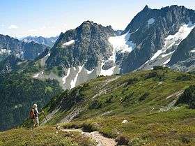
 Pelton Peak, northwest aspect | |
| Highest point | |
| Elevation | 7,132 ft (2,174 m) [1] |
| Prominence | 600 ft (180 m) [2] |
| Coordinates | 48°26′55″N 121°01′57″W [2] |
| Geography | |
 Pelton Peak Washington, U.S.  Pelton Peak Pelton Peak (the United States) | |
| Parent range | North Cascades Cascade Range |
| Topo map | USGS Cascade Pass |
| Geology | |
| Type of rock | OrthoGneiss, Schist |
| Climbing | |
| First ascent | August 3, 1948 by Lawrence E. Nielsen and Walt Price[3] |
| Easiest route | Scrambling via Magic-Pelton col[3] |
Climate
Pelton Peak is located in the marine west coast climate zone of western North America.[3] Most weather fronts originate in the Pacific Ocean, and travel northeast toward the Cascade Mountains. As fronts approach the North Cascades, they are forced upward by the peaks of the Cascade Range, causing them to drop their moisture in the form of rain or snowfall onto the Cascades (Orographic lift).

As a result, the west side of the North Cascades experiences high precipitation, especially during the winter months in the form of snowfall. During winter months, weather is usually cloudy, but, due to high pressure systems over the Pacific Ocean that intensify during summer months, there is often little or no cloud cover during the summer.[3] Because of maritime influence, snow tends to be wet and heavy, resulting in high avalanche danger.[3]
Geology
The North Cascades features some of the most rugged topography in the Cascade Range with craggy peaks and ridges, deep glacial valleys, and granite spires. Geological events occurring many years ago created the diverse topography and drastic elevation changes over the Cascade Range leading to the various climate differences. These climate differences lead to vegetation variety defining the ecoregions in this area.
The history of the formation of the Cascade Mountains dates back millions of years ago to the late Eocene Epoch.[4] With the North American Plate overriding the Pacific Plate, episodes of volcanic igneous activity persisted.[4] In addition, small fragments of the oceanic and continental lithosphere called terranes created the North Cascades about 50 million years ago.[4]
During the Pleistocene period dating back over two million years ago, glaciation advancing and retreating repeatedly scoured the landscape leaving deposits of rock debris.[4] The "U"-shaped cross section of the river valleys are a result of recent glaciation. Uplift and faulting in combination with glaciation have been the dominant processes which have created the tall peaks and deep valleys of the North Cascades area.
See also
- Geography of Washington (state)
- Geology of the Pacific Northwest
- List of Highest Mountain Peaks in Washington
References
- "Pelton Peak". Geographic Names Information System. United States Geological Survey. Retrieved 2019-10-29.
- "Pelton Peak, Washington". Peakbagger.com.
- Beckey, Fred W. Cascade Alpine Guide, Climbing and High Routes. Seattle, WA: Mountaineers Books, 2008.
- Kruckeberg, Arthur (1991). The Natural History of Puget Sound Country. University of Washington Press.
External links
- North Cascades National Park National Park Service
- Pelton Peak weather: Mountain Forecast
- Pelton Peak photo: Flickr