Optima Lake
Optima Lake was built to be a reservoir in Texas County, Oklahoma. The site is located just north of Hardesty and east of Guymon in the Oklahoma Panhandle.
| Optima Lake | |
|---|---|
 Optima Lake and Dam | |
| Location | Texas County, Oklahoma |
| Coordinates | 36°39′42″N 101°08′12″W[1] |
| Type | reservoir |
| Basin countries | United States |
| Surface elevation | 2,766 feet (843 m)[1] |
| Settlements | Hardesty, Oklahoma |
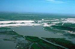
The earthen Optima Lake Dam (National ID # OK20510) was completed in 1978 by the United States Army Corps of Engineers, with a height of 120 feet, and a length at its crest of 16,875 feet.[2] Although designed to contain a maximum of 618,500 acre-feet of water, the lake never reached more than 5 percent of its capacity,[3] and remains effectively empty. Rapid declines in streamflow related to large-scale pumping from the High Plains Aquifer, also known as the Ogallala Aquifer, coincided with the completion of dam construction[3] to make this lake a dramatic example of unanticipated environmental impacts.[4]
The US Army Corps of Engineers website states (emphasis in original):
"Visitors should be aware that the lake's level can be very low. Depending on rainfall and evaporation rates, the lake may offer no water-based recreation and may not be suitable for swimming, fishing, boating or other activities. Visitors should come for the quiet natural setting--with or without water in the lake area." [5]
The lake surroundings offer few to no amenities since lake camping facilities and buildings were dismantled for public safety by the Corps of Engineers in 2010.
History
The project was originally included as part of the Flood Control Act of 1936, as modified by the Flood Control Act of 1950,[6][7] but planning and political wrangling delayed the start of construction until 1966.[8] The intent was for the reservoir to fill primarily from the flow of the Beaver River,[4] also known as the North Canadian River.[6] Normal flow on the Beaver River, from 1937 to 1966, averaged 32.2 cubic feet per second.[4] The river had occasional floods, including an October 1923 flood amounting to 109,000 acre-feet of water, and a September 1941 flood in which the Beaver's flow increased to 44,200 cubic feet per second.[6] The river's most recent flow of significance was in October 1965 at 17,800 cubic feet per second.[6] In the end the project was authorized for flood control, drinking and irrigation water in the relatively dry Oklahoma panhandle, recreation, and fish & wildlife conservation.[6]
The Guymon Chamber of Commerce, which enthusiastically backed the project, published a pamphlet that touted its expected virtues. The brochure forecast that the lake would be 100 feet (30 m) deep, and its arms would flood up to 10 miles (16 km) up Beaver River and 9 miles (14 km) along its tributary, Coldwater Creek.[8]
During the 12 years of construction by the U.S. Army Corps of Engineers, flow of the Beaver dropped.[4] It was later recognized that, because the source of the Beaver was the underground Ogallala Aquifer, being the water table beneath far western Oklahoma and parts of seven other Western states, and because of increased pressure on said aquifer due to expanded irrigation and drinking water withdrawals, the river's flow was being reduced to a trickle.[4]
The $46.1-million project was completed in 1978.[8] The dam was constructed as compacted earthfill embankment with gated outlet works and a 1,500-foot long uncontrolled saddle spillway.[6] The top of the dam is at 2,821.0 feet (859.8 m) of elevation above sea level.[6] The specifications put the top of the maximum pool at 2,814.2 feet (857.8 m), the top of the flood control pool at 2,779.0 feet (847.0 m), the top of the conservation pool at 2,763.5 feet (842.3 m), and the top of the inactive pool at 2,726.0 feet (830.9 m).[6] The conservation pool was designed to hold 117,500 acre-feet of water, with 76,200 acre-feet designated to be available as a water supply.[6] The flood pool capacity was designed for 229,500 acre-feet, while absolute maximum capacity of the lake was set at 618,500 acre feet.[6] Regarding expected visitorship, the Corps remained optimistic in 1979 and declared, "The optimum visitation for the project is 600,000 annual visitors and will be reached in 2014."[8]
But water flow in the Beaver, 1977–1987, averaged only 7 ft3/s, far less than the 32.2 ft3/s historical average.[4] In the mid-'80s, the Corps began to recognize that the reduced flow of the Beaver was permanent and the reservoir was not going to fill: the maximum lake level was achieved May 31, 1980 at an elevation of 2722.90 feet, whereas the very bottom of the conservation pool was intended to be 2726.00 feet.[6] Subsequently, the flow in the Beaver dropped even further. In the last five years (1989-1993) the U.S. Geological Survey could measure its current near Guymon, the Beaver's flow averaged less than one-fifth of 1 ft3/s.[9]
The Corps formally closed the park in 1995 although the site remained open to the public.[6] With funding from the American Recovery and Reinvestment Act of 2009, about 161 decaying structures including picnic enclosures, campsites, restrooms, dump stations and numerous power poles, were demolished by September 2010 for safety reasons.[6] As of 2014, the project was receiving 2000 to 5000 visitors annually.[8]
A spending controversy erupted in 2009, when the Corps wanted to use $1.2 million of economic stimulus money to replace rotting guardrails on each side of the paved road across the top of the Optima Dam used by approximately 15 cars a day.[10] Public criticism caused the Corps to instead gate and padlock the road at a cost of $1000.[10] Per the Corps’ September 2010 Section 216 Initial Appraisal Report on Optima Lake, the Corps continues to spend approximately $160,000/year for annual inspections of dam structures, detailed inspections at 5-year intervals, and repairs as budgets allow.[6] That same report indicates the existing dam structures (gate tower, stilling basin, uncontrolled spillway and outlet works) remain in operational condition.[6]
In the 1973 Environmental Impact Statement done by the Corps during the planning process, a “dry lake” option for the project was considered which would have provided for no water retention during normal periods, but would have created an area available as a flood containment pool in the event of abnormally large water events in the area.[11] That concept for Optima was rejected in favor of an active water-containment reservoir,[11] although the project as it currently exists is consistent with the “dry lake” option.[12] The Beaver does occasionally still carry off surface flooding after heavy rains, as in April 2016 when the river was flowing near Guymon for the first time in decades following two days of intense rains that caused Texas County to be declared a disaster area.[13]
The overall project included the Optima National Wildlife Refuge, run by the US Fish and Wildlife Service, being initially 2,605 acres (1,054 ha) along Coldwater Creek—which has its confluence with the Beaver 0.2 miles (0.32 km) upstream from the dam--[6] and the Optima Wildlife Management Area, public hunting lands managed by the Oklahoma Department of Wildlife Conservation, initially 2,141 acres (866 ha) along the Beaver.[6] However, the decreased size of the lake itself has led to Optima National Wildlife Refuge being increased to 4,334 acres (1,754 ha), and the area managed by Oklahoma, including licensed Corps lands above and below the dam, increasing to 8,062 acres (3,263 ha).[6]
Notes
- U.S. Geological Survey Geographic Names Information System: Optima Lake
- "Optima Lake Dam Details". Archived from the original on June 5, 2015. Retrieved September 4, 2012.
- Wahl, K & R. L. Tortorelli, 1996. "Changes in flow in the Beaver-North Canadian River Basin Upstream from Canton Lake, Western Oklahoma", USGS WRI 96-4304
- Layden, Logan (March 28, 2013). "If You Want to Build a New Lake in Oklahoma, Forget History". NPR. Retrieved June 1, 2015.
- U.S. Army Corps of Engineers Optima Lake website
- Section 216 Initial Appraisal Report, Optima Lake, September 2010, US Army Corps of Engineers"US Army Corps of Engineers, Tulsa District, website" (PDF). Retrieved June 1, 2015.
- The impact of Title II of Public Law 516-81st Congress, cited as The Flood Control Act of 1950, was that Optima had to be built in such a way as not to negatively impact Canton Lake, further downstream on the North Canadian River. The Arkansas River Basin section of the Act states with respect to Optima, “The Chief of Engineers is authorized to so design, construct and operate the Optima Reservoir, authorized by the Flood Control Act of 1936, as amended and supplemented, that, taken with the existing Fort Supply and Canton Reservoirs, there will remain at all times to the maximum extent practicable, conservation storage capacity in the Canton Reservoir authorized by existing law.” "Public Law 516-81st Congress" (PDF). U.S. Fish & Wildlife Service. Retrieved March 15, 2020.
- "Pictures from the Missing Lake". 405 Magazine, formerly Slice Magazine. Retrieved April 11, 2019.
- Actually .1864 of 1 cubic foot per second, calculated from the annual data at the U.S. Geological Survey Website waterdata.usgs.com, accessed 2017-05-23, using search parameters Surface Water, Historical Observations, Site Number, 07232500, Annual Statistics, checking the box for Discharge Cubic Feet Per Second, and submitting.
- Lester, Amy (September 11, 2009). "Stimulus Project Scrapped; Questions Remain Why It Was Ever Approved". News 9 Now and News on 6 Now. Retrieved June 1, 2015.
- "Optima Lake, North Canadian River: Environmental Impact Statement". U.S. Army Engineer District, June 1973, as available on the Google Books website. Retrieved May 10, 2019.
- As stated in the 2012 report, “Optima Lake regulates flow in the Beaver River at Beaver but does not sustain a water supply yield.” "Oklahoma Comprehensive Water Plan, Panhandle Watershed Planning Region Report, 2012, page 6" (PDF). Oklahoma Water Resources Board. Retrieved April 11, 2020.
- "Beaver River flows for first time in decades near Guymon". Travis Ruiz, Assistant News Director, Fox25 Oklahoma City, April 18, 2016. Retrieved May 10, 2019.
References
- R. Lowitt, 2002. "Optima Dam: A Failed Effort to Irrigate the Oklahoma Panhandle", Agricultural History, 76(2):260-72
External links
- 2006 Geological Society of America press release – Lessons to be learned from sites like Optima
- USGS online discharge data for inflow to reservoir (1937–1993)
- Optima Lake information on TravelOK.com Official travel and tourism website for the State of Oklahoma
- National Public Radio, 2013. "If You Want to Build a New Lake in Oklahoma, Forget History", NPR State Impact Oklahoma