Norwegian National Road 7
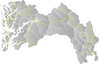
Norwegian National Road 7 (Norwegian: Riksvei 7) is a national road in Norway which runs from the town of Hønefoss in Viken county to the village of Granvin in Vestland county. The route is 387.6 kilometres (240.8 mi) long and runs east–west through Viken and Vestland counties over the vast Hardangervidda plateau.
| |
|---|---|
| Bokmål: Riksvei 7 Nynorsk: Riksveg 7 | |
  | |
| Route information | |
| Length | 387.6 km (240.8 mi) |
| Major junctions | |
| West end | Granvin |
| East end | Hønefoss |
| Highway system | |
| National Roads in Norway | |

The road begins at the European route E16 highway just south of Heradsbygda in Ringerike municipality and runs through the Sogna river valley to the village of Sokna (this part is called the Soknedalsveien). It then continues further on to Hamremoen and up along the east side of the lake Krøderen to Gulsvik where it crosses the river and then follows the Hallingdalen valley through Flå, Nesbyen, Gol, Torpo, Ål, Hol, and Geilo (this part is called the Hallingdalsveien). From there, the road begins its path across the Hardangervidda plateau via Ustaoset and Haugastøl, passing the Vøringsfossen waterfall while descending down into the Måbødalen valley in Eidfjord. The road follows the Eid Fjord for a ways before crossing the fjord via the Hardanger Bridge (opened in 2013 - there was a ferry here prior to that time). The road continues through the Vallavik Tunnel before reaching its terminus at the village of Granvin in Voss Municipality. The portion of the road from Haugestøl to Eidfjord (over the Hardangervidda plateau) is designated a National Tourist Route.
Improvements
In June 2014, a 17-kilometre (11 mi) long stretch of new road was opened in Ringerike-Krodsherad. Compared to the old road, it includes some long tunnels, is less curvaceous, and shortens the journey between Sokna to Ørgenvika.[1] The Hardanger Bridge (opened in 2013) also shortened the travel time, making road 7 the clearly fastest option for travelling Oslo–Bergen by road.
There are also some unofficial proposals to build a 15-kilometre (9.3 mi) long tunnel under the Hardangervidda plateau,[2] because this stretch is often closed due to snow storms in the winter.
References
| Wikimedia Commons has media related to Riksveg 7. |
- "Rv. 7 Sokna–Ørgenvika" (in Norwegian). Statens vegvesen. Archived from the original on 2014-07-06. Retrieved 2014-05-31.
- "Hardangervidda Tunnelen" (in Norwegian). Retrieved 2014-05-31.
National Tourist Routes | ||
|---|---|---|
|  | |