North Carolina Highway 41
North Carolina Highway 41 (NC 41) is a primary state highway in the U.S. state of North Carolina. The highway travels in a north–south orientation between the South Carolina state line to Lumberton, then switches to an east–west orientation connecting the cities and towns of Elizabethtown, White Lake, Harrells, Wallace, Beulaville and Trenton.[1]
| ||||
|---|---|---|---|---|
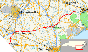 Route of NC 41 highlighted in red | ||||
| Route information | ||||
| Maintained by NCDOT | ||||
| Length | 141.1 mi (227.1 km) | |||
| Existed | 1928–present | |||
| Major junctions | ||||
| South end | ||||
| East end | ||||
| Location | ||||
| Counties | Robeson, Bladen, Sampson, Duplin, Jones, Craven | |||
| Highway system | ||||
| ||||

Route description
History
Future
A request was submitted by NCDOT Division 6 to restore NC 41 on its old alignment through Elizabethtown, via NC 87 Bus. Justification for the request was when it was rerouted in 1998, no signage and other NCDOT systems were revised; this would keep NC 41 as is.[2][3]
Major intersections
| County | Location | mi | km | Destinations | Notes |
|---|---|---|---|---|---|
| Robeson | Marietta | 0.0 | 0.0 | South Carolina state line | |
| 3.0 | 4.8 | ||||
| Fairmont | 9.1 | 14.6 | |||
| 9.7 | 15.6 | South end of NC 130 Bus overlap | |||
| 9.8 | 15.8 | North end of NC 130 Bus overlap | |||
| Lumberton | 16.9 | 27.2 | Diamond interchange | ||
| 20.4 | 32.8 | South end of NC 72 overlap | |||
| 20.9 | 33.6 | North end of concurrency with NC 72 | |||
| 22.3 | 35.9 | I-95/US 301, Exit 20 | |||
| Bladen | Dublin | 36.1 | 58.1 | ||
| 37.4 | 60.2 | ||||
| 39.1 | 62.9 | South end of NC 87 overlap | |||
| Elizabethtown | 40.9 | 65.8 | North end of NC 87 overlap; south end of NC 87 Bus overlap | ||
| 45.3 | 72.9 | North end of NC 87 Bus overlap; south end of US 701 and NC 242 overlaps | |||
| Suttons Corner | 46.6 | 75.0 | North end of NC 242 overlap; south end of NC 53 overlap | ||
| White Lake | 50.7 | 81.6 | North end of NC 53 overlap | ||
| 52.6 | 84.7 | North end of US 701 overlap | |||
| Smith Crossroads | 60.6 | 97.5 | |||
| Sampson | Harrells | 70.4 | 113.3 | South end of NC 411 overlap | |
| 71.8 | 115.6 | Eastern terminus of NC 411; north end of NC 411 overlap | |||
| Duplin | Wallace | 85.2 | 137.1 | ||
| 86.2 | 138.7 | ||||
| 88.1 | 141.8 | Diamond interchange; I-40, exit 385 | |||
| Chinquapin | 96.5 | 155.3 | South end of NC 50 overlap | ||
| 98.4 | 158.4 | North end of NC 50 overlap | |||
| 99.3 | 159.8 | South end of NC 111 overlap | |||
| Beulaville | 105.7 | 170.1 | |||
| 106.0 | 170.6 | North end of NC 111 overlap; southern terminus of NC 241 | |||
| Jones | | 115.6 | 186.0 | ||
| Trenton | 131.5 | 211.6 | South end of NC 58 overlap | ||
| 134.4 | 216.3 | North end of NC 58 overlap | |||
| Craven | Cove City | 141.1 | 227.1 | Diamond interchange | |
1.000 mi = 1.609 km; 1.000 km = 0.621 mi
| |||||
See also
- North Carolina Bicycle Route 5-concurrent with NC 41 along its US 701 concurrency from Sweet Home Church Road to NC 55 near White Lake
References
- Google (February 6, 2016). "North Carolina Highway 41" (Map). Google Maps. Google. Retrieved February 6, 2016.
- NC 41 Route Change Map (PDF) (Map). North Carolina Department of Transportation. January 9, 2013. Retrieved December 30, 2013.
- "NC 41 Route Change (2013-01-09)" (PDF). North Carolina Department of Transportation. January 9, 2013. Retrieved December 30, 2013.
External links

- NCRoads.com: N.C. 41
This article is issued from Wikipedia. The text is licensed under Creative Commons - Attribution - Sharealike. Additional terms may apply for the media files.