New Hampshire Route 136
New Hampshire Route 136 (abbreviated NH 136) is a 17.459-mile-long (28.098 km) east–west state highway in Hillsborough County in southern New Hampshire. The road connects New Boston and Peterborough.
| ||||
|---|---|---|---|---|
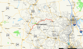 Map of Hillsborough County in southern New Hampshire with NH 136 highlighted in red | ||||
| Route information | ||||
| Maintained by NHDOT | ||||
| Length | 17.459 mi[1] (28.098 km) | |||
| Major junctions | ||||
| West end | ||||
| East end | ||||
| Location | ||||
| Counties | Hillsborough | |||
| Highway system | ||||
| ||||

The eastern terminus of NH 136 is at New Hampshire Route 13 in New Boston. The western terminus is in Peterborough at U.S. Route 202 and New Hampshire Route 123.
Major intersections
The entire route is in Hillsborough County. [1][2]
| Location[1][2] | mi[1][2] | km | Destinations | Notes | |
|---|---|---|---|---|---|
| Peterborough | 0.000 | 0.000 | Western terminus | ||
| Greenfield | 5.544 | 8.922 | Western end of concurrency with NH 31 | ||
| 5.601 | 9.014 | Eastern end of concurrency with NH 31 | |||
| Francestown | 9.926 | 15.974 | Southern terminus of NH 47 | ||
| New Boston | 17.124 | 27.558 | Northern end of concurrency with NH 77 | ||
| 17.459 | 28.098 | Eastern terminus Southern terminus of NH 77 | |||
1.000 mi = 1.609 km; 1.000 km = 0.621 mi
| |||||
References
- Bureau of Planning & Community Assistance (February 20, 2015). "NH Public Roads". Concord, New Hampshire: New Hampshire Department of Transportation. Retrieved April 7, 2015.
- Bureau of Planning & Community Assistance (April 3, 2015). "Nodal Reference 2015, State of New Hampshire". New Hampshire Department of Transportation. Retrieved April 7, 2015.
This article is issued from Wikipedia. The text is licensed under Creative Commons - Attribution - Sharealike. Additional terms may apply for the media files.