Navassa Island Light
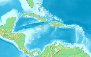
Navassa Island Light is a deactivated lighthouse on Navassa Island, which lies in the Caribbean Sea at the south end of the Windward Passage between the islands of Hispaniola (Haiti and the Dominican Republic) to the east and Cuba and Jamaica to the west. It is on the shortest route between the east coast of the United States and the Panama Canal. The light was built in 1917 and deactivated in 1996. The light is gradually deteriorating from lack of maintenance. The keepers' house is roofless and in ruins.[3]
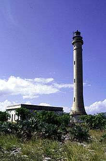 The light in 1999 | |
 | |

| |
| Location | Navassa Island Caribbean Sea |
|---|---|
| Coordinates | 18.397423°N 75.012833°W |
| Year first constructed | 1917 |
| Automated | 1929 |
| Deactivated | 1996 |
| Foundation | stone basement |
| Construction | concrete tower |
| Tower shape | tapered cylindrical tower with buttresses, balcony and lantern |
| Markings / pattern | white unpainted tower black lantern |
| Tower height | 162 feet (49 m) |
| Focal height | 395 feet (120 m) |
| Original lens | 2nd order Fresnel lens |
| Admiralty number | formerly J5362 |
| ARLHS number | NAV-001[1][2][3] |
| Managing agent | U.S. Fish and Wildlife Service |
The importance of the light before the advent of GPS is evident in the fact that it has the twelfth-highest tower and fourth-highest focal plane of all U.S. lights.
References
- "Historic Light Station Information and Photography: West Indies / Virgin Islands". United States Coast Guard Historian's Office. Archived from the original on 2017-05-01.
- Rowlett, Russ. "Navassa Island Lighthouse". The Lighthouse Directory. University of North Carolina at Chapel Hill.
- "Navassa Island". U.S. Geologic Survey.
This article is issued from Wikipedia. The text is licensed under Creative Commons - Attribution - Sharealike. Additional terms may apply for the media files.