National parks of Russia
There are currently 48 national parks in Russia, a list of which is given below. Together they cover approximately 155,672 square kilometers (60,105 sq mi).
Overview

The oldest parks in Russia are Sochinsky and Losiny Ostrov (1983); Samarskaya Luka (1984); Mariy Chodra (1985); Bashkiriya, Prielbrusye, Pribaykalsky, and Zabaykalsky (1986).[1]
According to the law on the protected areas of Russia, national parks are areas of land and water devoted to nature protection, ecological education, and scientific research. They contain sites of particular ecological, historical and aesthetic value. Regulated tourism is permitted.[2][3] The area of each park is divided into zones according to various functions. There should be a strictly protected area managed as a zapovednik, and also recreational and buffer zones in which economic activity is allowed, such as tourism, traditional land use, and benign forms of agriculture and forestry. The strictly protected function is sometimes fulfilled by a neighbouring official zapovednik; for instance, Barguzin Zapovednik adjoins Zabaykalsky National Park on the east side of Lake Baikal.[3] In 2001 Vodlozersky National Park received UNESCO Biosphere Reserve status, followed by Smolenskoye Poozerye and Ugra National Park in 2002, and two others (Valdaysky and Kenozersky) in 2004. The newest park is Bikin National Park, created in late 2015.[3]
The national parks are currently the responsibility of the Ministry of Natural Resources and Environment (Russia).[3]
List of national parks of Russia
| Name | Photo | Location | Created | Park URL | Area | Description |
|---|---|---|---|---|---|---|
| Alaniya |  |
North Ossetia-Alania 42°52′N 43°44′E |
1998 |
Ала́ния |
54,926 hectares (212.1 sq mi) |
Alaniya lies on the north slope of the central Caucasus Mountains. The park includes the 13 km long Karaugom Glacier, the deep forest valley of the Urukh River, and steppe grasslands. Archaeological ruins dot the park, from the Bronze Age Koban culture to the medieval Alans people. The host Republic of North Ossetia-Alania takes its name from the Alans.[4] |
| Alkhanay |  |
Zabaykalsky Krai 50°50′N 113°25′E |
1999 |
Алханай |
138,234 hectares (533.7 sq mi) |
Sacred to the indigenous Buryats people, as well as modern Buddhists, Mt. Alkhanai is the central focus of the park. (The Dalai Lama has made two unofficial visits). The surroundings are a prime example of "Daurian forest steppe", in the transition zone between the Siberian taiga to the north, and the Mongolian steppe just to the south.[5] |
| Anyuysky |  |
Khabarovsk Krai 49°26′N 136°33′E |
1999 |
Анюйский |
429,370 hectares (1,657.8 sq mi) |
The park is important because it creates an ecological corridor - from the low floodplain habitat of the Amur River, up through the forested Anyuy River basin, to the high levels of the Sikhote-Alin mountain range in the Russian Far East. The local indigenous people are the Nanai people, traditionally a fishing and hunting culture.[6] |
| Bashkiriya |  |
Bashkortostan 53°03′N 56°32′E |
1986 |
Башкирия |
92,000 hectares (355.2 sq mi) |
Bashkiriya covers a large contiguous forest and network of dissected river valleys on the southern end of the Ural mountains. The park is a buffer between the industrialized flat lands to the west, and the mountainous and sparsely-populated Shulgan-Tash Nature Reserve and Allyn-Solok ("Golden Bee Tree") entomological reserve to the east.[7] |
| Beringia |  |
Chukotka Autonomous Okrug 64°22′N 173°18′E |
2013 |
Берингия |
3,053,233 hectares (11,788.6 sq mi) |
Until 11,000 BCE, the Beringia "land bridge" allowed humans to pass between Asia and North America. Russia's Beringia National Park is the western side of what is now the Bering Strait, with the US Bering Land Bridge National Preserve in Alaska on the eastern side.[8] |
| Bikin | .jpg) |
Primorsky Krai 46°40′N 136°00′E |
2015 |
Бикин |
1,160,500 hectares (4,480.7 sq mi) |
Created Nov. 3, 2015, Bikin National Park protects the largest remaining old-growth mixed forest in the Northern Hemisphere, as well as the territory of 10% of all Amur tigers in the wild. The park also protects the forest culture of the 600 indigenous inhabitants that remain in the Bikin River basin, the Udeghes and Nanai people.[9] |
| Buzuluksky Bor |  |
Samara Oblast / Orenburg Oblast 53°00′N 52°7′E |
2007 |
Бузулукский бор |
106,000 hectares (409.3 sq mi) |
Buzuluksky Bor is the largest grove of isolated high pine trees in the world. Surrounded by a sea of steppes on the Eastern Russian Plain between the Volga River (west) and the southern Ural Mountains (to the east), the park is the sandy remains of what was once a river delta into the Caspian Sea. There is oil underneath Buzuluksky, adding pressure to the site.[10] |
| Chavash Varmane Bor |  |
Chuvashia 54°45′N 47°08′E |
1993 |
Чаваш Вармане |
25,200 hectares (97.3 sq mi) |
Chavash Varmane Bor is a large contiguous (unbroken) forest in the middle Volga River region. The park was created to serve the dual purpose of preserving biological diversity and the protection of a site representative of the Chuvash people.[11] |
| Chikoy |  |
Zabaykalsky Krai 49°46′N 110°18′E |
2014 |
Чикой |
666,468 hectares (2,573.2 sq mi) |
The park is at the headwaters of the Chikoy River, which flows west into the Selenga River and Lake Baikal, 250 miles to the northwest. It is in the transition zone between the Siberian taiga to the north and Mongolian steppe to the south.[12] |
| Kalevalsky |  |
Republic of Karelia 64°59′N 30°13′E |
2007 |
Калевальский |
74,400 hectares (287.3 sq mi) |
The Kalevalsky pine forest covers one of the last, large old-growth boreal pine forest in Europe. It is situated on the border between Russia and Finland at about the midpoint from south to north. The park is located in the Republic of Karelia. The Kalevala, an epic poem of Finnish and Karelian oral folklore, was drawn from this region.[13] |
| Curonian Spit |  |
Kaliningrad Oblast 55°08′N 20°48′E |
1987 |
Куршская коса |
6,621 hectares (25.6 sq mi) |
The Curonian Spit is a 98 km long, thin, curved sand-dune spit that separates the Curonian Lagoon from the Baltic Sea coast. Its southern portion lies within Kaliningrad Oblast, Russia and its northern within southwestern Lithuania. It is a UNESCO World Heritage Site shared by the two countries.[14] |
| Kenozersky |  |
Arkhangelsk Oblast 62°05′N 38°12′E |
1991 |
Кенозерский |
139,663 hectares (539.2 sq mi) |
The park has many cultural monuments, one being Porzhensky Pogost, which is St. George church with the bell-tower (both from the 18th century) surrounded by the wooden wall with gates and towers (1789). The park is on the divide between the Atlantic and Arctic basins. Since 2004, the National Park has the status of the UNESCO Biosphere Reserve.[15] |
| Khvalynsky |  |
Saratov Oblast 53°00′N 52°7′E |
1994 |
Хвалынский |
25,524 hectares (98.5 sq mi) |
Khvalynksy NP encompasses a raised plateau of chalk hills of the Volga Uplands, covered in mixed oak-linden and conifer forests, along the west side of the Volga River. It is about 1,000 km north of the Caspian Sea, in Saratov Oblast overlooking the Saratov Reservoir.[16] |
| Losiny Ostrov |  |
Moscow Oblast 53°52′N 37°47′E |
1983 |
Лосиный Остров |
11,600 hectares (44.8 sq mi) |
Literally, 'Moose Island', Losiny Ostrov is the first national park of Russia. It is located in Moscow and Moscow Oblast and is the third largest forest in a city of comparable size, after Table Mountain National Park (Cape Town) and Pedra Branca State Park (Rio de Janeiro).[17] |
| Mariy Chodra |  |
Mari El Republic 56°09′N 48°22′E |
1985 |
Марий Чодра |
36,600 hectares (141.3 sq mi) |
Mariy Chodra was created to protect rare plants: more than 115 rare plant species are documented. There are fourteen tourist routes in the park; the most popular attractions being Yalchik, Glukhoye, and Kichiyer Lakes, the rafting on the Ilet and Yushut Rivers, Pugachov's Oak, and the Maple Mountain.[18] |
| Meshchyora |  |
Vladimir Oblast 55°34′N 40°15′E |
1992 |
Мещёра |
118,900 hectares (459.1 sq mi) |
Meshchyora NP covers extensive wetlands (swamps, peat bogs, rivers and lakes) - an extremely rich habitat for biodiversity - and pine/birch woodlands in the Meshchera Lowlands on the East European Plain in Vladimir Oblast, about 120 km east of Moscow. The area is associated with the medieval Meshchera tribe.[19] |
| Meschyorsky |  |
Ryazan Oblast 55°08′N 40°10′E |
1992 |
Мещерский |
105,014 hectares (405.5 sq mi) |
"Meshchersky" (Мещёрский) National Park is not to be confused with "Meshchyora" (Мещёра) National Park, which is just to the north, over the border in Vladimir Oblast. The neighboring parks cover similar wetlands (swamps, peat bogs, rivers and lakes) and pine/birch woodlands in the Meshchera Lowlands.[20] |
| Nechkinsky |  |
Udmurt Republic 56°41′N 53°47′E |
1997 |
Нечкинский |
20,753 hectares (80.1 sq mi) |
Nechkinsky NP is an important biological and cultural reserve of Udmurtia (the Udmurt Republic), situated in the middle valley of the Kama River, its tributary the Siva River, and the coastal part of the Votkinsk reservoir. The territory is mostly forest and river floodplains, with a number of ancient archaeological sites on the grounds. It is near the city of Izhevsk, on the west side of the Ural Mountains.[21] |
| Nizhnyaya Kama | 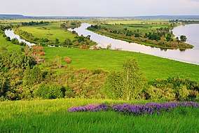 |
Tatarstan 55°48′N 52°19′E |
1991 |
Нижняя Кама |
26,587 hectares (102.7 sq mi) |
Literally translated as "Lower Kama National Park", Nizhnyaya Kama is a national park in the center of Russia, located in Tukayevsky and Yelabuzhsky Districts of Tatarstan. It was established April 20, 1991 to protect coniferous (mostly pine) forests at the banks of the Kama River.[22] |
| Onezhskoye Pomorye |  |
Arkhangelsk Oblast 64°47′N 37°18′E |
2013 |
Онежское Поморье |
201,670 hectares (778.7 sq mi) |
The park occupies much of the Onega Peninsula and adjacent parts of the White Sea. There are no all-season means of land transportation to the mainland. Most of the area is covered by forest.Moose, Eurasian brown bear, gray wolf, and red fox are common in the park. Beluga whale occurs in the White sea. In the winter, the sea is frozen.[23] |
| Orlovskoye Polesye |  |
Oryol Oblast 53°28′N 35°3′E |
1994 |
Орловское полесье |
77,745 hectares (300.2 sq mi) |
Orlovskoye Polesye is situated in the middle of the Central Russian Upland straddling the Znamensky and Khotynetsky districts of Oryol Oblast. The territory is a hills cut with ravines and gullies. The highest elevation is 250 meters above the sea level. In the low-lying areas there are muskeg with cranberries.[24] |
| Paanajärvi |  |
Republic of Karelia 66°29′N 37°18′E |
1992 |
Паанаярви |
104,371 hectares (403.0 sq mi) |
Paanajärvi National Park is located in the Karelia Region of northern Europe, along the Finnish–Russian border. It protects 1,043.71 square kilometres (402.98 sq mi) of pristine Scandinavian and Russian Taiga ecoregion forest habitats, lakes, and rivers.[25] |
| Pleshcheyevo Ozero |  |
Yaroslavl Oblast 56°46′N 38°44′E |
1997 |
Плещеево озеро |
23,790 hectares (91.9 sq mi) |
Pleshcheyevo NP covers Lake Pleshcheyevo and surrounding areas. The lake is highly popular for recreational use, as an ecological habitat, and is a former resort for the Russian tsars. The lake is located about 130 km northeast of Moscow, in the basin of the Upper Volga. On the southeast shore is the resort town of Pereslavl-Zalessky, Yaroslavl Oblast.[26] |
| Pribaikalsky | 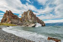 |
Irkutsk Oblast 51°51′N 104°53′E |
1986 |
Прибайкальский |
417,300 hectares (1,611.2 sq mi) |
Pribaikalsky National Park covers the southwest coast of Lake Baikalin southeastern Siberia. The coastal strip includes some mountain ridges to the west as well as offshore islands such as Olkhon Island to the east. It is about 50 km southeast of the city of Irkutsk, Irkutsk Oblast.[27] |
| Pripyshminskiye Bory |  |
Sverdlovsk Oblast 56°59′N 63°47′E |
1993 |
Припышминские Боры |
49,050 hectares (189.4 sq mi) |
Pripyshminskie Bora is located on the western edge of the West Siberian Plain . It protects a complex of pine and birch forests. About 10% of the area is non-forested marshes, ponds, hayfields and pastures.[28] |
| Prielbrusye |  |
Kabardino-Balkaria 43°21′N 42°34′E |
1986 |
Приэльбрусье |
1,010,200 hectares (3,900.4 sq mi) |
Prielbrusye is centered on Mt. Elbrus, the highest mountain in Europe at 5,632 meters above sea level. The relative isolation of steep gorges has led to high levels of endemism and biodiversity. The park is in the central Caucusus, just northwest of Alaniya National Park.[29] |
| Russian Arctic |  |
Arkhangelsk Oblast 75°42′N 60°54′E |
1986 |
Русская Арктика |
1,426,000 hectares (5,505.8 sq mi) |
Russian Arctic National Park covers a large and remote area of the Arctic Ocean, the northern part of Novaya Zemlya (Severny Island), and Franz Josef Land.[30] |
| Russky Sever |  |
Vologda Oblast 59°57′N 38°34′E |
1992 |
Русский Север |
166,400 hectares (642.5 sq mi) |
The name of the park means Russian North in Russian. The park protects natural and cultural landscapes around Kirillo-Belozersky Monastery and Ferapontov Monastery, places of great historical significance.[31] |
| Samarskaya Luka |  |
Samara Oblast 53°18′N 49°50′E |
1984 |
Самарская Лука |
134,000 hectares (517.4 sq mi) |
The park (in English, "Samara Bend") is on the 180-degree bend of the Volga River as it flows south by the City of Samara. It is on the shore of the Kuibyshevskoye water reservoir, and on the north it has a border with Zhigulevsky Zapovednik. Most of the bedrock is karst (limestone) formation. |
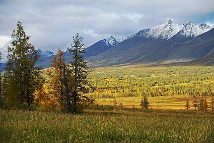
| Saylyugemsky |  |
Altai Republic 49°31′N 88°37′E |
2010 |
Сайлюгемский |
118,380 hectares (457.1 sq mi) |
Created as a special preserve for the Altai Snow Leopard and the Altai mountain sheep (argali), Saylyugemsky National Park rises in the Altai-Sayan Mountains, on the border between Russia and Mongolia.[33] |
| Sebezhsky |  |
Pskov Oblast 56°16′N 28°30′E |
1996 |
Себежский |
50,021 hectares (193.1 sq mi) |
Sebezhsky National Park is located in the southwestern part of Sebezhsky District, where the national park is located, is essentially hilly landscape of glacial origin with many lakes. The area is forested, with pine, spruce, mixed, and alder forests.[34] |
| Shantar Islands |  |
Khabarovsk Krai 55°00′N 137°30′E |
2014 |
Шантарские острова |
250,000 hectares (965.3 sq mi) |
The Shantar Islands are a group of 15 islands that lie off the coast of Khabarovsk Krai, in the Sea of Okhotsk. Most of the islands have rugged cliffs, and the highest point is 720 meters. They are home to Steller Sea Lions, seals, and Bowhead whales.[35] |
| Shorsky |  |
Kemerovo Oblast 52°35′N 88°20′E |
1989 |
Шорский |
418,000 hectares (1,613.9 sq mi) |
Shorsky National Park is a forested, mountainous area in southwestern Siberia, where the West Siberian Plain meets the South Siberian Mountains . It is representative of areas with dark taiga tree cover (92% of the park is forested).[36] |
| Smolenskoye Poozerye |  |
Smolensk Oblast 55°32′N 31°24′E |
1992 |
Смоленское Поозерье |
146,237 hectares (564.6 sq mi) |
"Smolensk Lakes" is a forest-wetland ecosystem of 35 lakes and surroundings in the northwest of Smolensk Oblast near the Russian border with Belarus. It is in the basin of the Daugava (river) (also called the "Western Dvina" River), about 40 miles (64 km) north of the city of Smolensk.[37] |
| Smolny |  |
Republic of Mordovia 54°50′N 45°40′E |
1995 |
Смольный |
36,500 hectares (140.9 sq mi) |
The park has a representative lowland river environment, with a slow current. The lakes and swamps are mainly concentrated in the floodplain of the Alatyr River. Marshes are mainly lowland. A few bogs are located in the southern and central parts of the park. There are many springs. |
| Sochi |  |
Krasnodar Krai 43°05′N 39°43′E |
1995 |
Сочинский |
193,737 hectares (748.0 sq mi) |
The park occupies the Greater Sochi area, from the border with the Tuapsinsky District, between the mouths of Shepsi River and Magri River in the north-west, to the border with Abkhazia along the Psou River in the south-east, and between the Black Sea to the water divide crest of the Greater Caucasus.[39] |
| Taganay |  |
Chelyabinsk Oblast 55°15′N 59°47′E |
1991 |
Таганай |
56,800 hectares (219.3 sq mi) |
Taganay is a group of mountain ridges in the Southern Urals, on the territory of Chelyabinsk Oblast, with the highest point rising 1178 m. above sea level.[40] |
| Tarkhankut |  |
Autonomous Republic of Crimea 45°25′N 32°32′E |
1991 |
Тарханкутский |
10,900 hectares (42.1 sq mi) |
The park is located on the western tip of the Tarkhankut peninsula in the Black Sea region. The park is predominantly steppe areas Tarkhankut hills and beams (White, Castel, Ternovaya), which cut into the hill. The park surrounds virtually all West Coast.[41] |
| Tunkinsky |  |
Buryatia 51°41′N 102°08′E |
1991 |
Тункинский |
1,183,662 hectares (4,570.1 sq mi) |
Tunkinsky is in south central Siberia, and covers a mountainous region centered on the Irkut River valley (also referred to as the Tunka Valley) that continues from the rift valley of Lake Baikalsouthwest to the border of Mongolia. To the north and west of the valley is the eastern edge of the Sayan Mountains.[42] |
| Udegeyskaya Legenda |  |
Primorsky Krai 45°49′N 135°25′E |
1991 |
Удэгейская легенда |
103,744 hectares (400.6 sq mi) |
Udege Legend covers the richest coniferous-deciduous forest on the western slope of the Central Sikhote-Alin mountains of the Russian Far East. The park is designed to protect west-slope river valley habitat, and to support the remnant of the indigenous Udege people. The area is known for abundant fishing and boating on the streams and rivers. It is also a refuge for the endangered Amur Tiger.[43] |
| Ugra |  |
Kaluga Oblast 54°09′N 35°52′E |
1997 |
Угра |
98,600 hectares (380.7 sq mi) |
Ugra National Park is a forested areas southwest of Moscow. It is located in the Kaluga region, the valleys of the rivers Ugra, Zhizdra, Vyssa and Oka.[44] |
| Valdaysky |  |
Novgorod Oblast 57°59′N 31°15′E |
1990 |
Валдайский |
158,500 hectares (612.0 sq mi) |
Since 2004, the National Park has the status of a UNESCO Biosphere Reserve. Valdaysky National Park, which includes the town of Valday, Lake Valdayskoye, and the northern part of Lake Seliger, is one of the most popular tourist destinations in Central Russia and has well-developed tourist infrastructure.[45] |
| Vodlozersky |  |
Arkhangelsk Oblast 62°39′N 37°05′E |
1991 |
Водлозерский |
428,000 hectares (1,652.5 sq mi) |
The park area includes Lake Vodlozero, the river basin of the Ileksa, the main inflow of the lake, and the upper course of the Vodla. In 2001, Vodlozersky was designate a UNESCO Biodiversity Reserve site.[46] |
| Yugyd Va | |
Komi Republic 62°25′N 58°47′E |
1994 |
Югыд ва |
1,891,700 hectares (7,303.9 sq mi) |
The Yugyd Va park covers a territory in the Northern Ural Mountains and adjacent foothills and flatlands. The entire park is within the Pechora River basin, i.e. west of the Europe-Asia continental divide; this means that all of it is geographically in Europe.[47] |
| Zabaykalsky |  |
Buryat Republic 53°43′N 109°13′E |
1986 |
Забайкальский |
269,000 hectares (1,038.6 sq mi) |
Zaybaykalsky National Park covers a section of the eastern shore of Lake Baikal.[48] |
| Land of the Leopard | .jpg) |
Primorsky Krai 43°00′N 131°25′E |
2012 |
Земля леопарда |
80,000 hectares (308.9 sq mi) |
The main aim of the park is to preserve and restore the population of the unique spotted cat - the Amur leopard, which number in Russia is now only about 50 individuals. Today, more than half of them lives in the "Land of the Leopard." In addition, there lives and another cat, listed in the Red Book - the Amur tiger.[49] |
| Zov Tigra |  |
Primorsky Krai 43°35′N 134°16′E |
2007 |
Зов Тигра |
83,384 hectares (321.9 sq mi) |
Zov Tigra is a mountainous refuge for the endangered Amur Tiger. The park encompasses an area of 83,384 hectares (206,046 acres; 834 km2; 322 sq mi) on the far southeast coast of Russia's Far East in the federal district Primorsky Krai (in English, "Maritime Region").[50] |
| Zyuratkul |  |
Chelyabinsk Oblast 54°51′N 58°56′E |
1993 |
Зюраткуль |
88,200 hectares (340.5 sq mi) |
Notable features include Zyuratkul' Lake, a rare mountainous body of water for the Urals 754 m above sea level, with a surface area of 13,2 km2 and a maximum depth of 8 m. Water is slightly mineralised (≈50 mg/L). Because of its clear water and spectacular landscape around, Zyuratkul' is often called "Ural Ritsa".[51]
- |
Footnotes
- Russian Nature Press
- "About Special Protected Nature Areas", a Russian Federation federal law of March 14, 1995.(in Russian)
- Biodiversity Conservation Centre Moscow
- "Alaniya National Park - Official Park Website (in Russian)". FGBU Alaniya. Retrieved December 27, 2015.
- "Alkhanay National Park - Official Park Website (in Russian)". FGBU Alkhanay. Retrieved December 27, 2015.
- "Anyuysky National Park (in Russian)". Ministry of Natural Resources of the Russian Federation. Retrieved December 27, 2015.
- "Bashkiriya National Park (in Russian)". Ministry of Education and Science of the Russian Federation. Retrieved December 27, 2015.
- "Beringia National Park - Official Park Website (in English)". FGBU Beringia. Retrieved December 27, 2015.
- "Directive Creating Bikin National Park". Ministry of Natural Resources of the Russian Federation. Retrieved January 10, 2016.
- "Buzuluksky Bor National Park (in Russian)". FGBU AARI PA (PA Russia). Retrieved December 27, 2015.
- "Chavash Varmane Bor National Park - Official Park Website (in Russian)". FGBU Chavash Varmane Bor. Retrieved December 27, 2015.
- "Chikoy National Park - Official Park Website (in Russian)". Ministry of Natural Resources of the Russian Federation. Retrieved December 27, 2015.
- "Kalevalsky National Park - Official Park Website (in Russian)". Ministry of Natural Resources of the Russian Federation. Retrieved December 31, 2015.
- "Kurshskaya Kosa National Park - Official Park Website (in Russian)". FGBU Kurshskaya. Retrieved December 27, 2015.
- "Kenozersky National Park - Official Park Website (in English)". FGBU Kenozersky. Retrieved December 27, 2015.
- "Khvalynsky National Park - Official Park Website (in Russian)". Scientific Tourism, Saratov Oblast. Retrieved December 27, 2015.
- "Losiny Ostrov National Park - Official Park Website (in Russian)". FGBU Losiny Ostrov. Retrieved December 27, 2015.
- "Mariy Chodra National Park - Official Park Website (in Russian)". FGBU Mariy Chodra. Retrieved December 27, 2015.
- "Meshchyora National Park - Official Park Website (in Russian)". FGBU Meshchyora. Retrieved December 27, 2015.
- "Meshchyorsky National Park - Official Park Website (in Russian)". FGBU Meshchyorsky. Archived from the original on December 22, 2015. Retrieved December 27, 2015.
- "Nechkinsky National Park - Official Park Website (in Russian)". FGBU Nechkinsky. Retrieved December 27, 2015.
- "National Park - Official Park Website (in Russian)". FGBU Nizhnyaya. Retrieved December 27, 2015.
- "Onezhskoye Pomorye National Park - Official Park Website (in Russian)". Ministry of Natural Resources and Ecology of the Russian Federation. Retrieved December 27, 2015.
- "Orlovskoye Polesye National Park - Official Park Website (in Russian)". FGBU Orlovskoye Polesye. Retrieved December 27, 2015.
- "Paanajärvi National Park - (in English)". European Commission 2007. Retrieved December 27, 2015.
- "Pleshcheyevo Ozero National Park - Official Park Website (in Russian)". FGBU Pleshcheyevo Ozero. Retrieved December 27, 2015.
- "Pribaikalsky National Park - Official Park Website (in Russian)". FGBU Pribaikalsky. Retrieved December 27, 2015.
- "Pripyshminskiye Bory National Park - Official Park Website (in Russian)". FGBU Pripyshminskiye Bory. Retrieved December 27, 2015.
- "Prielbrusye National Park - Official Park Website (in Russian)". FGBU Prielbrusye. Retrieved December 27, 2015.
- "Russian Arctic National Park (in Russian)". Nenets Autoonomous Okrug. Retrieved December 27, 2015.
- "Russky Sever National Park - Official Park Website (in Russian)". FGBU Russky Sever. Retrieved December 27, 2015.
- "Samarskaya Luka National Park - Official Park Website (in Russian)". FGBU Samarskaya Luka. Retrieved December 27, 2015.
- "Saylyugemsky National Park - Official Park Website (in Russian)". Ministry of Natural Resources of the Russian Federation. Retrieved December 27, 2015.
- "Sebezhsky National Park - Official Park Website (in Russian)". FGBU Sebezhsky. Retrieved December 27, 2015.
- "[Shantar Islands National Park - Official Park Website (in Russian)". Ministry of Natural Resources of the Russian Federation. Retrieved December 27, 2015.
- "Shorsky National Park - Official Park Website (in Russian)". FGBU Shorsky. Retrieved December 27, 2015.
- "Smolenskoye Poozerye National Park - Official Park Website (in Russian)". FGBU Smolenskoye Poozerye. Archived from the original on December 26, 2015. Retrieved December 27, 2015.
- "Smolny National Park - Official Park Website (in Russian)". ProtectedPlanet.org. Retrieved December 27, 2015.
- "Sochi National Park - Official Park Website (in Russian)". Sochi National Park. Retrieved December 27, 2015.
- "Taganay National Park - Official Park Website (in Russian)". FGBU Taganay. Retrieved December 27, 2015.
- "Tarkhankut National Park - Official Park Website (in Russian)". FGBU Tarhankut. Retrieved December 27, 2015.
- "Tunkinsky National Park - Official Park Website (in Russian)". FGBU Tunkinsky. Archived from the original on April 13, 2012. Retrieved December 27, 2015.
- "Udegeyskaya Legenda National Park - Official Park Website (in Russian)". FGBU Udegeyskaya Legenda. Retrieved December 27, 2015.
- "Ugra National Park - Official Park Website (in Russian)". FGBU Ugra. Retrieved December 27, 2015.
- "Valdaysky National Park - Official Park Website (in Russian)". FGBU Valdaysky. Retrieved December 27, 2015.
- "Vodlozersky National Park - Official Park Website (in Russian)". Ministry of Natural Resources of the Russian Federation. Retrieved December 27, 2015.
- "Yugyd Va National Park - Official Park Website (in Russian)". FGBU Yugyd Va. Retrieved December 27, 2015.
- "Zabaykalsky National Park - Official Park Website (in Russian)". Ministry of Natural Resources of the Russian Federation. Retrieved December 27, 2015.
- "Land of the Leopard National Park - Official Park Website (in Russian)". FGBU Land of the Leopard. Retrieved December 27, 2015.
- "Zov Tigra National Park - Official Park Website (in Russian)". FGBU Lazovsky/Zov Tigra. Archived from the original on 2015-12-05. Retrieved December 27, 2015.
- "Zyuratkul National Park - Official Park Website (in Russian)". FGBU Zyuratkul. Retrieved December 27, 2015.
External links
| Wikimedia Commons has media related to National parks of Russia. |
- Biodiversity Conservation Center/Tsentr dikoy prirody, Moscow: page and map on each park, in Russian.
- Centre for Russian Nature Conservation/Russian Conservation News.
