National Register of Historic Places listings in Yolo County, California
This is a list of the National Register of Historic Places listings in Yolo County, California.
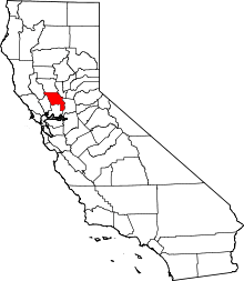
Location of Yolo County in California
This is intended to be a complete list of the properties and districts on the National Register of Historic Places in Yolo County, California, United States. Latitude and longitude coordinates are provided for many National Register properties and districts; these locations may be seen together in an online map.[1]
There are 26 properties and districts listed on the National Register in the county. Another property was once listed but has been removed.
- This National Park Service list is complete through NPS recent listings posted August 14, 2020.[2]
Current listings
| [3] | Name on the Register[4] | Image | Date listed[5] | Location | City or town | Description |
|---|---|---|---|---|---|---|
| 1 | Animal Science Building | 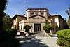 Animal Science Building |
June 17, 1986 (#86001354) |
University of California, West Quad and Peter J. Shields Ave. 38°32′27″N 121°45′00″W |
Davis | |
| 2 | R. H. Beamer House | 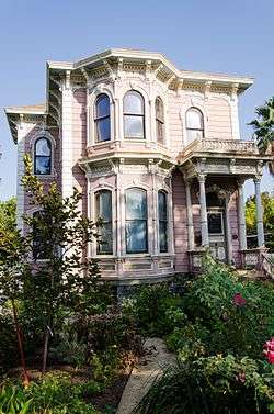 R. H. Beamer House |
August 2, 1982 (#82002283) |
19 3rd St. 38°41′02″N 121°46′09″W |
Woodland | |
| 3 | Canon School | 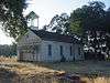 Canon School |
June 13, 1972 (#72000264) |
0.5 mi (0.80 km) north of Brooks 38°44′57″N 122°06′16″W |
Brooks | |
| 4 | Davis Subway | 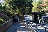 Davis Subway |
June 26, 1998 (#98000713) |
Richards Boulevard between Olive Dr. and 1st St. 38°32′30″N 121°44′20″W |
Davis | |
| 5 | Downtown Woodland Historic District | 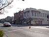 Downtown Woodland Historic District |
June 22, 1999 (#99000471) |
Roughly along Main St. from Elm St. to 3rd St. 38°40′40″N 121°46′20″W |
Woodland | |
| 6 | Dresbach-Hunt-Boyer House | 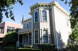 Dresbach-Hunt-Boyer House |
September 13, 1976 (#76000540) |
604 2nd St. 38°32′36″N 121°44′22″W |
Davis | |
| 7 | William B. Gibson House | 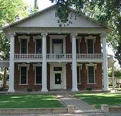 William B. Gibson House |
November 7, 1976 (#76000542) |
512 Gibson Rd. 38°39′45″N 121°46′22″W |
Woodland | |
| 8 | Hotel Woodland | 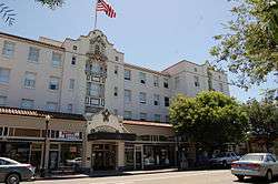 Hotel Woodland |
October 21, 1994 (#94001225) |
426 Main St. 38°40′38″N 121°46′26″W |
Woodland | |
| 9 | I Street Bridge | .jpg) I Street Bridge |
April 22, 1982 (#82002233) |
Former State Route 16 38°35′10″N 121°30′23″W |
Sacramento | |
| 10 | I.O.O.F. Building | 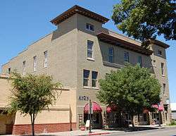 I.O.O.F. Building |
February 25, 1982 (#82002284) |
723 Main St. 38°40′40″N 121°46′11″W |
Woodland | |
| 11 | Main Street Historic District- Winters | 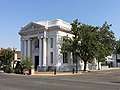 Main Street Historic District- Winters |
January 2, 1997 (#96001536) |
1-48 Main St. 38°31′18″N 121°58′06″W |
Winters | |
| 12 | James Moore House | November 16, 1978 (#78000827) |
Southwest of Woodland 38°38′30″N 121°50′14″W |
Woodland | ||
| 13 | Nelson Ranch | 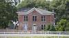 Nelson Ranch |
July 17, 1972 (#72000266) |
County Road 18C between County Road 102 and California State Route 113 38°42′40″N 121°44′23″W |
Woodland | |
| 14 | Porter Building | 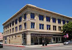 Porter Building |
November 30, 1978 (#78000828) |
501-511 Main St. 38°40′40″N 121°46′24″W |
Woodland | |
| 15 | Rumsey Town Hall |  Rumsey Town Hall |
June 19, 1972 (#72000265) |
State Route 16 at Manzanita St. 38°53′19″N 122°14′12″W |
Rumsey | |
| 16 | Southern Pacific Railroad Station | 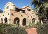 Southern Pacific Railroad Station |
November 7, 1976 (#76000541) |
H and 2nd Sts. 38°32′37″N 121°44′12″W |
Davis | |
| 17 | TB-9 | 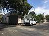 TB-9 |
April 5, 2016 (#16000153) |
SW corner of Old Davis Rd. and Hutchinson Dr., University of California, Davis 38°32′23″N 121°44′46″W |
Davis | Temporary Building 9 |
| 18 | Tower Bridge | 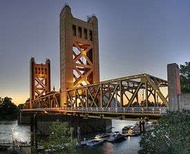 Tower Bridge |
June 24, 1982 (#82004845) |
State Route 275 across the Sacramento River 38°34′48″N 121°30′30″W |
Sacramento | |
| 19 | Joshua B. Tufts House | 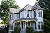 Joshua B. Tufts House |
September 6, 1979 (#79000571) |
434 J St. 38°32′52″N 121°44′06″W |
Davis | |
| 20 | Union Church of Dunnigan | 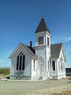 Union Church of Dunnigan |
July 10, 2003 (#03000613) |
3615 County Road 89A 38°53′11″N 121°58′02″W |
Dunnigan | |
| 21 | Walnut Street School | 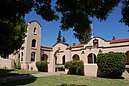 Walnut Street School |
March 20, 2006 (#06000144) |
175 Walnut St. 38°40′50″N 121°46′37″W |
Woodland | |
| 17 | Washington Firehouse |  Washington Firehouse |
April 17, 2017 (#100000882) |
317 3rd St. 38°35′17″N 121°30′36″W |
West Sacramento | |
| 22 | Woodland Opera House |  Woodland Opera House |
November 5, 1971 (#71000212) |
320 2nd St. 38°40′40″N 121°46′15″W |
Woodland | |
| 23 | Woodland Public Library | 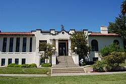 Woodland Public Library |
September 28, 1981 (#81000183) |
250 1st St. 38°40′45″N 121°46′21″W |
Woodland | |
| 24 | Yolo Branch Library | 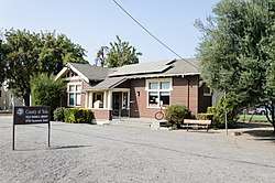 Yolo Branch Library |
December 10, 1990 (#90001810) |
200 Sacramento St. 38°44′00″N 121°48′22″W |
Yolo | |
| 25 | Yolo County Courthouse | 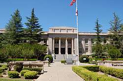 Yolo County Courthouse |
February 26, 1987 (#86003660) |
725 Court St. 38°40′45″N 121°46′16″W |
Woodland |
Former listing
| [3] | Name on the Register | Image | Date listed | Date removed | Location | City or town | Summary |
|---|---|---|---|---|---|---|---|
| 1 | First Pacific Coast Salmon Cannery Site | April 6, 1974 (#66000938) | July 14, 2004 | On the Sacramento River, opposite the foot of K Street |
Broderick | Former National Historic Landmark[6] |
See also
| Wikimedia Commons has media related to National Register of Historic Places in Yolo County, California. |
References
- The latitude and longitude information provided in this table was derived originally from the National Register Information System, which has been found to be fairly accurate for about 99% of listings. Some locations in this table may have been corrected to current GPS standards.
- "National Register of Historic Places: Weekly List Actions". National Park Service, United States Department of the Interior. Retrieved on August 14, 2020.
- Numbers represent an ordering by significant words. Various colorings, defined here, differentiate National Historic Landmarks and historic districts from other NRHP buildings, structures, sites or objects.
- "National Register Information System". National Register of Historic Places. National Park Service. July 9, 2010.
- The eight-digit number below each date is the number assigned to each location in the National Register Information System database, which can be viewed by clicking the number.
| Topics | |
|---|---|
| Lists by state |
|
| Lists by insular areas | |
| Lists by associated state | |
| Other areas | |
| Related | |
| |
Municipalities and communities of Yolo County, California, United States | ||
|---|---|---|
| Cities | Yolo County map | |
| CDPs | ||
| Unincorporated communities |
| |
| Ghost towns | ||
| Footnotes | ‡This populated place also has portions in an adjacent county or counties | |
This article is issued from Wikipedia. The text is licensed under Creative Commons - Attribution - Sharealike. Additional terms may apply for the media files.