National Register of Historic Places listings in St. Martin Parish, Louisiana
This is a list of the National Register of Historic Places listings in St. Martin Parish, Louisiana.

Location of St. Martin Parish in Louisiana
This is intended to be a complete list of the properties and districts on the National Register of Historic Places in St. Martin Parish, Louisiana, United States. The locations of National Register properties and districts for which the latitude and longitude coordinates are included below, may be seen in a map.[1]
There are 25 properties and districts listed on the National Register in the parish, including 1 National Historic Landmark.
- This National Park Service list is complete through NPS recent listings posted August 14, 2020.[2]
Current listings
| [3] | Name on the Register[4] | Image | Date listed[5] | Location | City or town | Description |
|---|---|---|---|---|---|---|
| 1 | Bonin House | 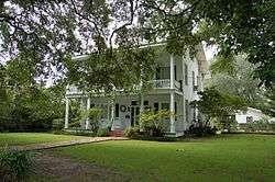 Bonin House |
January 27, 1997 (#96001609) |
421 N. Main St. 30°07′39″N 91°49′41″W |
St. Martinville | |
| 2 | Breaux Bridge Historic District | 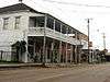 Breaux Bridge Historic District |
July 28, 1995 (#95000907) |
Roughly bounded by Bayou Teche, Van Buren St., Main St., and Bridge St. 30°16′26″N 91°53′55″W |
Breaux Bridge | |
| 3 | Burdin House | December 9, 1999 (#99001479) |
422 N. Pinaud St. 30°07′40″N 91°49′25″W |
St. Martinville | ||
| 4 | Dautreuil House | 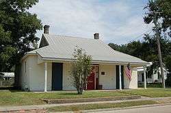 Dautreuil House |
March 30, 1995 (#95000356) |
517 E. Bridge St. 30°07′21″N 91°49′28″W |
St. Martinville | |
| 5 | Fontenette-Bienvenu House | August 21, 1997 (#97000876) |
201 N. Main St. 30°07′30″N 91°49′44″W |
St. Martinville | ||
| 6 | Fontenette-Durand Maison Dimanche | April 19, 1984 (#84001356) |
Louisiana Highway 94 30°15′56″N 91°55′40″W |
Breaux Bridge | ||
| 7 | Fourgeaud House |  Fourgeaud House |
May 5, 1999 (#99000527) |
130 S. Main St. 30°16′23″N 91°53′56″W |
Breaux Bridge | |
| 8 | Katie Plantation House | June 29, 2001 (#01000669) |
1015 John D. Hebert Dr. 30°13′03″N 91°54′16″W |
Breaux Bridge | ||
| 9 | Levert-St. John Bridge | 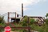 Levert-St. John Bridge |
March 26, 1998 (#98000268) |
O'Neal Boudreaux Rd. over the Bayou Teche 30°09′29″N 91°48′43″W |
St. Martinville | |
| 10 | Maison Olivier (Acadian House) |  Maison Olivier (Acadian House) |
March 30, 1973 (#73002133) |
1200 N. Main St., within Longfellow-Evangeline State Historic Site 30°08′17″N 91°49′30″W |
St. Martinville | National Historic Landmark |
| 11 | Old Castillo Hotel | 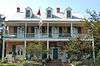 Old Castillo Hotel |
July 24, 1979 (#79003122) |
220 Port St. 30°07′17″N 91°49′39″W |
St. Martinville | |
| 12 | Olivier Pigeonnier |  Olivier Pigeonnier |
March 14, 1983 (#83000541) |
Southwest of Breaux Bridge off Louisiana Highway 94 30°15′57″N 91°55′43″W |
Breaux Bridge | |
| 13 | Patin House | 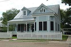 Patin House |
November 13, 1991 (#91001680) |
219 W. Bridge St. 30°16′19″N 91°54′01″W |
Breaux Bridge | |
| 14 | Pellerin-Chauffe House | 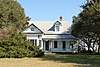 Pellerin-Chauffe House |
April 5, 1984 (#84001358) |
South of Breaux Bridge on Louisiana Highway 347 30°15′35″N 91°52′57″W |
Breaux Bridge | |
| 15 | Henri Penne House | 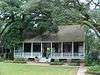 Henri Penne House |
June 9, 1980 (#80004252) |
West of Breaux Bridge 30°15′54″N 91°55′42″W |
Breaux Bridge | |
| 16 | Ransonet House |  Ransonet House |
May 10, 1990 (#90000748) |
431 E. Bridge St. 30°16′32″N 91°53′53″W |
Breaux Bridge | |
| 17 | St. Martin of Tours Catholic Church |  St. Martin of Tours Catholic Church |
April 10, 1972 (#72001454) |
133 S. Main St. 30°07′22″N 91°49′41″W |
St. Martinville | |
| 18 | St. Martin Parish Courthouse |  St. Martin Parish Courthouse |
November 19, 1981 (#81000658) |
S. Main St. 30°07′09″N 91°49′47″W |
St. Martinville | |
| 19 | St. Martinville Elementary School | 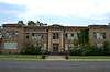 St. Martinville Elementary School |
October 18, 1996 (#96001162) |
303 Church St. 30°07′17″N 91°49′59″W |
St. Martinville | |
| 20 | St. Martinville Historic District | January 27, 1983 (#83000542) |
Louisiana Highways 31 and 96 30°07′24″N 91°49′42″W |
St. Martinville | ||
| 21 | Sandoz House | October 29, 1982 (#82000456) |
West of St. Martinville on Louisiana Highway 96 30°08′03″N 91°53′35″W |
St. Martinville | ||
| 22 | Soulier House | 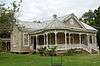 Soulier House |
May 23, 1997 (#97000466) |
417 N. Main St. 30°07′36″N 91°49′42″W |
St. Martinville | |
| 23 | Stephanie Plantation House | 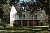 Stephanie Plantation House |
May 20, 1998 (#98000570) |
1862 Louisiana Highway 347 30°21′16″N 91°52′44″W |
Arnaudville | |
| 24 | U.S. Post Office | 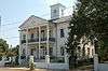 U.S. Post Office |
April 5, 1972 (#72001455) |
Main and Port Sts. 30°07′19″N 91°49′45″W |
St. Martinville | |
| 25 | D. W. Voorhies House | October 16, 2008 (#08001011) |
410 Washington St. 30°07′14″N 91°49′55″W |
St. Martinville |
See also
| Wikimedia Commons has media related to National Register of Historic Places in Saint Martin Parish, Louisiana. |
References
- The latitude and longitude information provided in this table was derived originally from the National Register Information System, which has been found to be fairly accurate for about 99% of listings. Some locations in this table may have been corrected to current GPS standards.
- "National Register of Historic Places: Weekly List Actions". National Park Service, United States Department of the Interior. Retrieved on August 14, 2020.
- Numbers represent an ordering by significant words. Various colorings, defined here, differentiate National Historic Landmarks and historic districts from other NRHP buildings, structures, sites or objects.
- "National Register Information System". National Register of Historic Places. National Park Service. March 13, 2009.
- The eight-digit number below each date is the number assigned to each location in the National Register Information System database, which can be viewed by clicking the number.
| Topics | |
|---|---|
| Lists by state |
|
| Lists by insular areas | |
| Lists by associated state | |
| Other areas | |
| Related | |
| |
Municipalities and communities of St. Martin Parish, Louisiana, United States | ||
|---|---|---|
Parish seat: St. Martinville | ||
| Cities | | |
| Towns | ||
| Village | ||
| CDPs | ||
| Other unincorporated communities |
| |
| Ghost town | ||
| Footnotes | ‡This populated place also has portions in an adjacent parish or parishes | |
This article is issued from Wikipedia. The text is licensed under Creative Commons - Attribution - Sharealike. Additional terms may apply for the media files.