National Register of Historic Places listings in Nevada County, California
This is a list of the National Register of Historic Places listings in Nevada County, California.
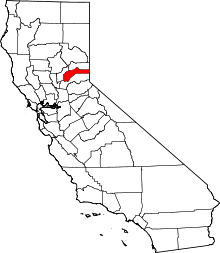
Location of Nevada County in California
This is intended to be a complete list of the properties and districts on the National Register of Historic Places in Nevada County, California, United States. Latitude and longitude coordinates are provided for many National Register properties and districts; these locations may be seen together in a Google map.[1]
There are 23 properties and districts listed on the National Register in the county, including 1 National Historic Landmark.
- This National Park Service list is complete through NPS recent listings posted August 14, 2020.[2]
Current listings
| [3] | Name on the Register[4] | Image | Date listed[5] | Location | City or town | Description |
|---|---|---|---|---|---|---|
| 1 | Boca Dam | 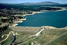 Boca Dam |
March 25, 1981 (#81000712) |
S end of Boca Reservoir 39°23′26″N 120°05′36″W |
Truckee | |
| 2 | Bridgeport Covered Bridge | 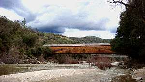 Bridgeport Covered Bridge |
July 14, 1971 (#71000168) |
SW of French Corral over S. Yuba River 39°17′01″N 121°11′40″W |
French Corral | |
| 3 | Commercial Row-Brickelltown Historic District | 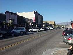 Commercial Row-Brickelltown Historic District |
October 8, 2009 (#09000803) |
Roughly the north side of Donner Pass Rd. from Bridge St. westwards approx. 1,700 ft. 39°19′39″N 120°11′12″W |
Truckee | |
| 4 | Davis Mill | April 1, 2010 (#10000157) |
Off North Bloomfield Road; 3 miles NE of Nevada City 39°17′26″N 120°59′18″W |
Nevada City | ||
| 5 | Donner Camp | 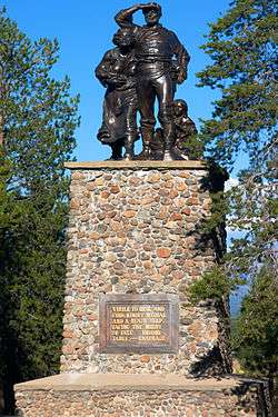 Donner Camp |
October 15, 1966 (#66000218) |
2.6 mi. W of Truckee on U.S. 40 39°21′18″N 120°11′27″W |
Truckee | |
| 6 | Empire Mine |  Empire Mine |
December 9, 1977 (#77000318) |
SE of Grass Valley at 338 E. Empire St. 39°12′13″N 121°02′34″W |
Grass Valley | Boundary increase on 2013-04-10 |
| 7 | Foote's Crossing Road | January 29, 1981 (#81000180) |
Tahoe National Forest 39°24′53″N 120°57′35″W |
North Columbia | ||
| 8 | Grass Valley Public Library |  Grass Valley Public Library |
March 26, 1992 (#92000267) |
207 Mill St. 39°12′58″N 121°03′50″W |
Grass Valley | |
| 9 | Kruger House | 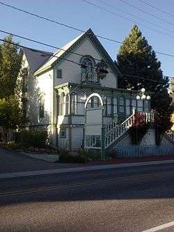 Kruger House |
June 17, 1982 (#82002220) |
10292 Donner Pass Rd. 39°19′35″N 120°11′18″W |
Truckee | |
| 10 | Malakoff Diggins-North Bloomfield Historic District | .JPG) Malakoff Diggins-North Bloomfield Historic District |
April 11, 1973 (#73000418) |
Graniteville Star Route 39°22′16″N 120°54′44″W |
North Bloomfield | |
| 11 | Martin Luther Marsh House | 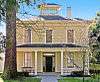 Martin Luther Marsh House |
April 11, 1973 (#73000415) |
254 Boulder St. 39°16′03″N 121°00′32″W |
Nevada City | |
| 12 | Meadow Lake Petroglyphs | May 6, 1971 (#71000169) |
Address Restricted |
French Lake | ||
| 13 | Mount St. Mary's Academy and Convent | .jpg) Mount St. Mary's Academy and Convent |
May 3, 1974 (#74000543) |
Church and Chapel Sts. 39°12′53″N 121°04′03″W |
Grass Valley | |
| 14 | National Exchange Hotel | 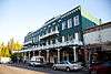 National Exchange Hotel |
October 25, 1973 (#73000416) |
211 Broad St. 39°15′45″N 121°01′01″W |
Nevada City | |
| 15 | Nevada Brewery | 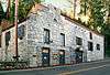 Nevada Brewery |
September 12, 1985 (#85002303) |
107 Sacramento St. 39°15′42″N 121°00′53″W |
Nevada City | |
| 16 | Nevada City Downtown Historic District | 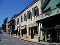 Nevada City Downtown Historic District |
September 23, 1985 (#85002520) |
Roughly bounded by Spring, Bridge, Commercial, York, Washington, Coyote, and Main Sts. 39°15′47″N 121°01′03″W |
Nevada City | |
| 17 | Nevada City Firehouse No. 2 | 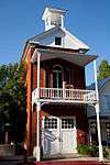 Nevada City Firehouse No. 2 |
May 3, 1974 (#74000544) |
420 Broad St. 39°15′47″N 121°01′09″W |
Nevada City | |
| 18 | Nevada City Free Public Library | 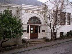 Nevada City Free Public Library |
December 10, 1990 (#90001809) |
211 N. Pine St. 39°15′52″N 121°00′59″W |
Nevada City | |
| 19 | Nevada Theatre |  Nevada Theatre |
March 14, 1973 (#73000417) |
Broad and Bridge Sts. 39°15′47″N 121°01′09″W |
Nevada City | |
| 20 | North Star House | 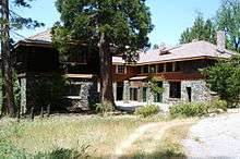 North Star House |
February 1, 2011 (#10001191) |
12075 Old Auburn Rd. 39°11′39″N 121°04′35″W |
Grass Valley | |
| 21 | Ott's Assay Office | 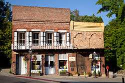 Ott's Assay Office |
April 14, 1975 (#75000447) |
130 Main St. 39°15′47″N 121°00′56″W |
Nevada City | |
| 22 | Red Dog Townsite | September 14, 2001 (#01000968) |
Address Restricted |
Nevada City | ||
| 23 | Aaron A. Sargent House | 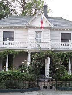 Aaron A. Sargent House |
June 20, 1980 (#80000825) |
449 Broad St. 39°15′49″N 121°01′14″W |
Nevada City |
See also
| Wikimedia Commons has media related to National Register of Historic Places in Nevada County, California. |
- List of National Historic Landmarks in California
- National Register of Historic Places listings in California
- California Historical Landmarks in Nevada County, California
References
- The latitude and longitude information provided in this table was derived originally from the National Register Information System, which has been found to be fairly accurate for about 99% of listings. Some locations in this table may have been corrected to current GPS standards.
- "National Register of Historic Places: Weekly List Actions". National Park Service, United States Department of the Interior. Retrieved on August 14, 2020.
- Numbers represent an ordering by significant words. Various colorings, defined here, differentiate National Historic Landmarks and historic districts from other NRHP buildings, structures, sites or objects.
- "National Register Information System". National Register of Historic Places. National Park Service. July 9, 2010.
- The eight-digit number below each date is the number assigned to each location in the National Register Information System database, which can be viewed by clicking the number.
| Topics | |
|---|---|
| Lists by state |
|
| Lists by insular areas | |
| Lists by associated state | |
| Other areas | |
| Related | |
| |
This article is issued from Wikipedia. The text is licensed under Creative Commons - Attribution - Sharealike. Additional terms may apply for the media files.