National Register of Historic Places listings in Monroe County, Illinois
This is a list of the National Register of Historic Places listings in Monroe County, Illinois.

Location of Monroe County in Illinois
This is intended to be a complete list of the properties and districts on the National Register of Historic Places in Monroe County, Illinois, United States. Latitude and longitude coordinates are provided for many National Register properties and districts; these locations may be seen together in a map.[1]
There are 7 properties and districts listed on the National Register in the county. Another property was once listed but has been removed.
- This National Park Service list is complete through NPS recent listings posted August 14, 2020.[2]
Current listings
| [3] | Name on the Register | Image | Date listed[4] | Location | City or town | Description |
|---|---|---|---|---|---|---|
| 1 | Fountain Creek Bridge |  Fountain Creek Bridge |
December 22, 1978 (#78001176) |
Off Illinois Route 156 38°19′33″N 90°11′45″W |
Waterloo | |
| 2 | French Colonial Historic District |  French Colonial Historic District |
April 3, 1974 (#74000772) |
From Fort Chartres State Park to Kaskaskia Island 38°07′01″N 90°12′30″W |
Prairie du Rocher | Extends into Randolph County |
| 3 | Gundlach-Grosse House | 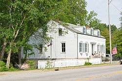 Gundlach-Grosse House |
December 18, 1978 (#78001173) |
625 N. Main St. 38°26′54″N 90°12′17″W |
Columbia | |
| 4 | Lunsford-Pulcher Archeological Site | 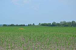 Lunsford-Pulcher Archeological Site |
July 23, 1973 (#73000712) |
Western side of Oklahoma Hill Rd.[5] 38°29′40″N 90°13′52″W |
Columbia | Extends into St. Clair County |
| 5 | Maeystown Historic District |  Maeystown Historic District |
June 23, 1978 (#78001174) |
Illinois Route 7 38°13′34″N 90°14′01″W |
Maeystown | |
| 6 | Peterstown House | 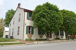 Peterstown House |
November 16, 1977 (#77000489) |
275 N. Main St. 38°20′32″N 90°09′03″W |
Waterloo | |
| 7 | Waterloo Historic District |  Waterloo Historic District |
December 1, 1978 (#78001177) |
Most of the central portion of the city, roughly bounded by Morrison, Moore, Konigsmark, and Hickory/Oak/Elm 38°20′06″N 90°09′06″W |
Waterloo |
Former listing
| [3] | Name on the Register | Image | Date listed | Date removed | Location | City or town | Summary |
|---|---|---|---|---|---|---|---|
| 1 | Stephen W. Miles House | November 28, 1978 (#78001175) | Unknown | Northwest of Valmeyer off Illinois Route 156 |
Valmeyer |
See also
| Wikimedia Commons has media related to National Register of Historic Places in Monroe County, Illinois. |
References
- The latitude and longitude information provided in this table was derived originally from the National Register Information System, which has been found to be fairly accurate for about 99% of listings. Some locations in this table may have been corrected to current GPS standards.
- "National Register of Historic Places: Weekly List Actions". National Park Service, United States Department of the Interior. Retrieved on August 14, 2020.
- Numbers represent an ordering by significant words. Various colorings, defined here, differentiate National Historic Landmarks and historic districts from other NRHP buildings, structures, sites or objects.
- The eight-digit number below each date is the number assigned to each location in the National Register Information System database, which can be viewed by clicking the number.
- Fowler, Melvin L., and Glen A. Freimuth. National Register of Historic Places Inventory/Nomination: Lunsford-Pulcher Archeological Site. National Park Service, n.d., 4.
| Topics | |
|---|---|
| Lists by state |
|
| Lists by insular areas | |
| Lists by associated state | |
| Other areas | |
| Related | |
| |
Municipalities and communities of Monroe County, Illinois, United States | ||
|---|---|---|
| Cities | Map of Illinois highlighting Monroe County | |
| Villages | ||
| Unincorporated communities | ||
| Footnotes | ‡This populated place also has portions in an adjacent county or counties | |
This article is issued from Wikipedia. The text is licensed under Creative Commons - Attribution - Sharealike. Additional terms may apply for the media files.